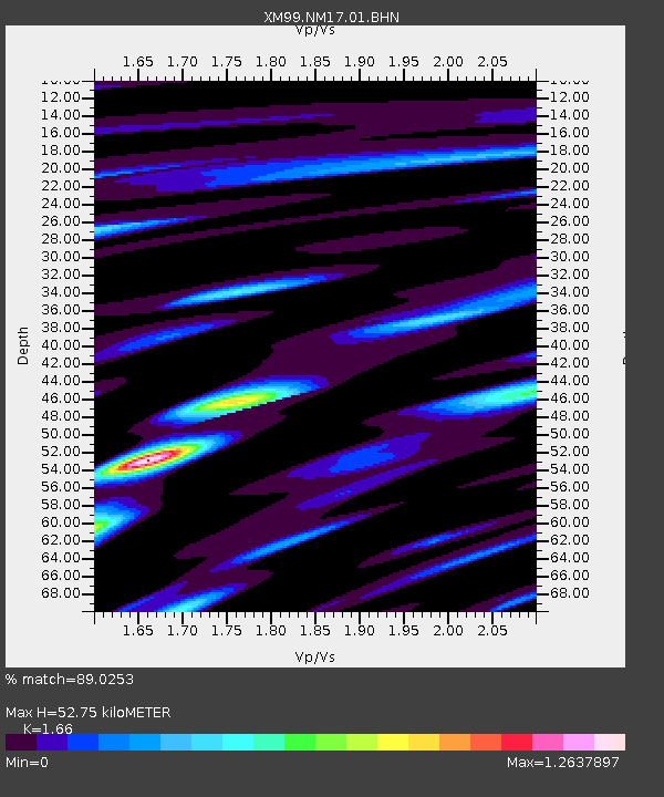
NM17 NewMexico17 - Earthquake Result Viewer

Earthquake location: Alaska Peninsula
Earthquake latitude/longitude: 54.7/-161.2
Earthquake time(UTC): 1999/10/13 (286) 01:33:40 GMT
Earthquake Depth: 30 km
Earthquake Magnitude: 6.0 MB, 6.2 MS, 6.5 MW, 6.0 ML
Earthquake Catalog/Contributor: WHDF/NEIC
Network: XM Rio Grande Seismic Transect
Station: NM17 NewMexico17
Lat/Lon: 33.26 N/105.17 W
Elevation: 1705 m
Distance: 44.2 deg
Az: 95.266 deg
Baz: 316.328 deg
Ray Param: 0.07198022
Estimated Moho Depth: 52.75 km
Estimated Crust Vp/Vs: 1.66
Assumed Crust Vp: 6.232 km/s
Estimated Crust Vs: 3.754 km/s
Estimated Crust Poisson's Ratio: 0.22
Radial Match: 89.0253 %
Radial Bump: 391
Transverse Match: 80.14564 %
Transverse Bump: 400
SOD ConfigId: 27569
Insert Time: 2010-02-26 17:25:50.829 +0000
GWidth: 2.5
Max Bumps: 400
Tol: 0.001

Signal To Noise

ChannelStoNSTALTA
XM:NM17:01:BHN:19991013T01:41:16.162013Z1.71372712.0335266E-71.1866105E-7
XM:NM17:01:BHE:19991013T01:41:16.162013Z1.11921021.5408338E-71.3767152E-7
XM:NM17:01:BHZ:19991013T01:41:16.162013Z2.39710433.0772625E-71.2837415E-7
Arrivals
Ps6.0 SECOND
PpPs21 SECOND
PsPs/PpSs27 SECOND