You are here: Home > Network List > XM99 - Rio Grande Seismic Transect Stations List
> Station NM17 NewMexico17 > Earthquake Result Viewer
NM17 NewMexico17 - Earthquake Result Viewer
| Earthquake location: |
Kodiak Island Region, Alaska |
| Earthquake latitude/longitude: |
57.4/-154.5 |
| Earthquake time(UTC): |
1999/12/06 (340) 23:12:33 GMT |
| Earthquake Depth: |
66 km |
| Earthquake Magnitude: |
6.8 MB, 7.0 MW, 7.0 ML |
| Earthquake Catalog/Contributor: |
WHDF/NEIC |
|
| Network: |
XM Rio Grande Seismic Transect |
| Station: |
NM17 NewMexico17 |
| Lat/Lon: |
33.26 N/105.17 W |
| Elevation: |
1705 m |
|
| Distance: |
41.0 deg |
| Az: |
104.47 deg |
| Baz: |
321.292 deg |
| Ray Param: |
0.073854394 |
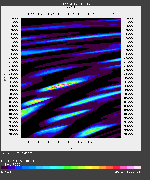
| Estimated Moho Depth: |
43.75 km |
| Estimated Crust Vp/Vs: |
1.79 |
| Assumed Crust Vp: |
6.232 km/s |
| Estimated Crust Vs: |
3.476 km/s |
| Estimated Crust Poisson's Ratio: |
0.27 |
|
| Radial Match: |
97.54559 % |
| Radial Bump: |
400 |
| Transverse Match: |
87.862465 % |
| Transverse Bump: |
400 |
| SOD ConfigId: |
27569 |
| Insert Time: |
2010-02-26 17:25:52.408 +0000 |
| GWidth: |
2.5 |
| Max Bumps: |
400 |
| Tol: |
0.001 |
|

Signal To Noise
| Channel | StoN | STA | LTA |
| XM:NM17:01:BHN:19991206T23:19:40.159014Z | 13.325199 | 1.2038595E-6 | 9.034458E-8 |
| XM:NM17:01:BHE:19991206T23:19:40.159014Z | 5.7383537 | 8.9854933E-7 | 1.565866E-7 |
| XM:NM17:01:BHZ:19991206T23:19:40.159014Z | 12.684397 | 2.5952404E-6 | 2.0460102E-7 |
| Arrivals |
| Ps | 5.9 SECOND |
| PpPs | 18 SECOND |
| PsPs/PpSs | 24 SECOND |


