You are here: Home > Network List > XM99 - Rio Grande Seismic Transect Stations List
> Station NM17 NewMexico17 > Earthquake Result Viewer
NM17 NewMexico17 - Earthquake Result Viewer
| Earthquake location: |
Tonga Islands |
| Earthquake latitude/longitude: |
-15.9/-174.0 |
| Earthquake time(UTC): |
1999/12/07 (341) 21:29:49 GMT |
| Earthquake Depth: |
138 km |
| Earthquake Magnitude: |
6.2 MB, 6.4 MW, 6.4 MW |
| Earthquake Catalog/Contributor: |
WHDF/NEIC |
|
| Network: |
XM Rio Grande Seismic Transect |
| Station: |
NM17 NewMexico17 |
| Lat/Lon: |
33.26 N/105.17 W |
| Elevation: |
1705 m |
|
| Distance: |
81.8 deg |
| Az: |
52.123 deg |
| Baz: |
245.012 deg |
| Ray Param: |
0.04701473 |
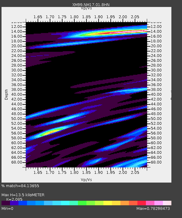
| Estimated Moho Depth: |
13.5 km |
| Estimated Crust Vp/Vs: |
2.09 |
| Assumed Crust Vp: |
6.232 km/s |
| Estimated Crust Vs: |
2.989 km/s |
| Estimated Crust Poisson's Ratio: |
0.35 |
|
| Radial Match: |
84.13655 % |
| Radial Bump: |
400 |
| Transverse Match: |
58.60117 % |
| Transverse Bump: |
400 |
| SOD ConfigId: |
27569 |
| Insert Time: |
2010-02-26 17:25:53.205 +0000 |
| GWidth: |
2.5 |
| Max Bumps: |
400 |
| Tol: |
0.001 |
|

Signal To Noise
| Channel | StoN | STA | LTA |
| XM:NM17:01:BHN:19991207T21:41:21.759014Z | 2.550681 | 6.048852E-7 | 2.3714652E-7 |
| XM:NM17:01:BHE:19991207T21:41:21.759014Z | 8.153575 | 1.1009628E-6 | 1.3502823E-7 |
| XM:NM17:01:BHZ:19991207T21:41:21.759014Z | 13.924692 | 2.3413406E-6 | 1.6814307E-7 |
| Arrivals |
| Ps | 2.4 SECOND |
| PpPs | 6.5 SECOND |
| PsPs/PpSs | 8.9 SECOND |


