You are here: Home > Network List > XJ97 - Sierran Paradox Stations List
> Station FLL Florence Lake > Earthquake Result Viewer
FLL Florence Lake - Earthquake Result Viewer
| Earthquake location: |
Colombia |
| Earthquake latitude/longitude: |
3.8/-75.7 |
| Earthquake time(UTC): |
1997/09/02 (245) 12:13:22 GMT |
| Earthquake Depth: |
199 km |
| Earthquake Magnitude: |
6.5 MB, 6.8 UNKNOWN, 6.4 ME |
| Earthquake Catalog/Contributor: |
WHDF/NEIC |
|
| Network: |
XJ Sierran Paradox |
| Station: |
FLL Florence Lake |
| Lat/Lon: |
37.28 N/118.97 W |
| Elevation: |
2237 m |
|
| Distance: |
51.7 deg |
| Az: |
315.866 deg |
| Baz: |
119.419 deg |
| Ray Param: |
0.06655102 |
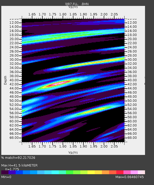
| Estimated Moho Depth: |
41.5 km |
| Estimated Crust Vp/Vs: |
1.77 |
| Assumed Crust Vp: |
6.291 km/s |
| Estimated Crust Vs: |
3.544 km/s |
| Estimated Crust Poisson's Ratio: |
0.27 |
|
| Radial Match: |
92.217026 % |
| Radial Bump: |
312 |
| Transverse Match: |
82.377205 % |
| Transverse Bump: |
400 |
| SOD ConfigId: |
6273 |
| Insert Time: |
2010-03-09 20:11:02.553 +0000 |
| GWidth: |
2.5 |
| Max Bumps: |
400 |
| Tol: |
0.001 |
|

Signal To Noise
| Channel | StoN | STA | LTA |
| XJ:FLL: :BHN:19970902T12:21:38.695013Z | 8.125757 | 3.1268425E-7 | 3.848063E-8 |
| XJ:FLL: :BHE:19970902T12:21:38.695013Z | 12.242731 | 5.0168063E-7 | 4.0977838E-8 |
| XJ:FLL: :BHZ:19970902T12:21:38.695013Z | 18.60972 | 1.3754731E-6 | 7.3911536E-8 |
| Arrivals |
| Ps | 5.4 SECOND |
| PpPs | 17 SECOND |
| PsPs/PpSs | 23 SECOND |


