
Station XJ FLL - Florence Lake
Network: XJ97 - Sierran Paradox
Nearby stations (2 deg radius)
| Station | Name | (Lat, Lon) | Start / End | Elevation |
| FLL | Florence Lake | (37.28, -118.97) | 1997-06-11 / 1997-12-31 | 2237 m |
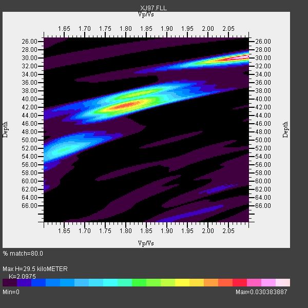
| Crust2 Type: | M9,thick extended crust, 0.5 km seds. |
| Thickness Estimate: | 30 km |
| Thickness StdDev: | 6.1 km |
| Vp/Vs Estimate: | 2.10 |
| Vp/Vs StdDev: | 0.15 |
| Vs Estimate: | 2.999 km/s |
| Poisson's Ratio: | 0.35 |
| Peak Value: | 0.03 |
| Assumed Vp: | 6.291 km/s |
| Ps Weight: | 0.33333334 |
| PpPs Weight: | 0.33333334 |
| PsPs Weight: | 0.33333328 |
| Residual Complexity: | 0.770 |
| Nearby stations H: | 30 km +- 0.0 km |
| (2.0 deg) Vp/Vs: | 2.10 +- 0.00 |
5 with match > 90% ( 23.809525 %) and 10 with match > 80% ( 47.61905 %) out of 21.
Download stack as xyz text file.
Azimuth Distribution of Events:

Prior Results for this Station
| Study | Thickness | Vp/Vs | Vp | Vs | Poissons Ratio | Extra |
| EARS | 30 km | 2.10 | 6.291 km/s | 2.999 km/s | 0.35 | |
| Crust2.0 | 40 km | 1.78 | 6.291 km/s | 3.539 km/s | 0.27 | M9,thick extended crust, 0.5 km seds. |
| Global Maxima | 30 km | 2.10 | 6.291 km/s | 2.999 km/s | 0.35 | amp=0.030383887 |
| Local Maxima 1 | 42 km | 1.79 | 6.291 km/s | 3.51 km/s | 0.27 | amp=0.023096042 |
| Local Maxima 2 | 42 km | 1.82 | 6.291 km/s | 3.457 km/s | 0.28 | amp=0.01236053 |
| Local Maxima 3 | 52 km | 1.65 | 6.291 km/s | 3.801 km/s | 0.21 | amp=0.009034484 |
| Local Maxima 4 | 40 km | 1.78 | 6.291 km/s | 3.534 km/s | 0.27 | amp=0.008292212 |
| Predicted Arrivals for vertical incidence (zero ray parameter) | |
| Ps | 5.15 SECOND |
| PpPs | 14.52 SECOND |
| PsPs/PpSs | 19.67 SECOND |
Events Processed for this Station
Download zip of receiver functions as SAC
Plot maxima for each earthquake.
Events Used in the Stack
(10 events)| Radial Match | Distance | Baz | FERegion | Time | Lat/Lon | Depth | Magnitude |
| 93.98945 | 56.3 deg | 103.215 deg | Near Coast Of Venezuela | 1997/07/09 19:24:13 GMT | (10.6, -63.5) | 20 km | 6.2 MB, 6.8 MS, 7.0 UNKNOWN, 6.6 ME |
| 92.93636 | 36.8 deg | 310.301 deg | Fox Islands, Aleutian Islands | 1997/07/20 00:30:20 GMT | (52.6, -167.5) | 14 km | 5.6 MB, 5.9 MS, 6.2 UNKNOWN, 6.2 MW |
| 92.2943 | 80.2 deg | 139.872 deg | Near Coast Of Central Chile | 1997/07/06 09:54:00 GMT | (-30.1, -71.9) | 19 km | 5.8 MB, 6.5 MS, 6.8 UNKNOWN, 6.4 ME |
| 92.217026 | 51.7 deg | 119.419 deg | Colombia | 1997/09/02 12:13:22 GMT | (3.8, -75.7) | 199 km | 6.5 MB, 6.8 UNKNOWN, 6.4 ME |
| 91.299934 | 86.6 deg | 232.862 deg | South Of Fiji Islands | 1997/09/04 04:23:37 GMT | (-26.6, 178.3) | 625 km | 6.3 MB, 6.8 UNKNOWN, 6.5 ME |
| 86.12495 | 68.6 deg | 308.547 deg | Kuril Islands | 1997/07/14 16:09:35 GMT | (43.2, 146.4) | 33 km | 5.9 MB, 5.8 MS, 6.1 UNKNOWN, 5.8 ME |
| 85.168434 | 43.2 deg | 160.477 deg | Central East Pacific Rise | 1997/08/15 07:37:49 GMT | (-4.4, -105.7) | 10 km | 5.3 MB, 5.8 MS, 6.2 UNKNOWN, 6.1 MW |
| 85.023056 | 85.6 deg | 228.815 deg | Kermadec Islands Region | 1997/09/20 16:11:32 GMT | (-28.7, -177.6) | 30 km | 6.1 MB, 7.0 MS, 7.2 UNKNOWN, 6.7 ME |
| 84.33883 | 77.8 deg | 131.429 deg | Jujuy Province, Argentina | 1997/07/20 10:14:22 GMT | (-23.0, -66.3) | 256 km | 5.7 MB, 6.1 UNKNOWN, 5.7 ME |
| 84.19891 | 80.6 deg | 140.14 deg | Near Coast Of Central Chile | 1997/07/27 05:21:29 GMT | (-30.5, -71.9) | 33 km | 5.6 MB, 5.8 MS, 6.3 UNKNOWN, 6.2 MW |
Losers
(11 events)| Radial Match | Distance | Baz | FERegion | Time | Lat/Lon | Depth | Magnitude | Reason |
| 76.0186 | 80.5 deg | 140.138 deg | Near Coast Of Central Chile | 1997/07/25 06:47:02 GMT | (-30.5, -71.9) | 33 km | 5.6 MB, 5.5 MS, 6.3 UNKNOWN | |
| 73.06863 | 79.7 deg | 139.271 deg | Near Coast Of Central Chile | 1997/07/19 12:22:57 GMT | (-29.3, -71.7) | 26 km | 5.8 MB, 5.5 MS, 5.9 UNKNOWN, 5.8 MW | |
| 66.54305 | 93.2 deg | 304.746 deg | Southwestern Ryukyu Isl., Japan | 1997/08/13 04:45:04 GMT | (25.0, 125.8) | 55 km | 6.0 MB, 5.6 MS, 6.1 UNKNOWN, 6.1 MW | |
| 65.590614 | 90.9 deg | 263.168 deg | Solomon Islands | 1997/09/07 12:57:06 GMT | (-6.0, 154.5) | 421 km | 5.6 MB, 5.8 UNKNOWN, 5.8 MW | |
| 64.535095 | 80.4 deg | 140.066 deg | Near Coast Of Central Chile | 1997/07/21 23:19:39 GMT | (-30.3, -71.9) | 33 km | 5.2 MB, 5.5 MS, 6.1 UNKNOWN | |
| 61.856846 | 82.2 deg | 293.821 deg | Volcano Islands, Japan Region | 1997/07/08 02:24:07 GMT | (23.8, 142.7) | 33 km | 5.8 MB, 5.6 MS, 5.9 UNKNOWN, 5.8 MW | |
| 58.298187 | 80.0 deg | 234.358 deg | Fiji Islands Region | 1997/08/25 11:59:00 GMT | (-20.8, -177.8) | 394 km | 5.5 UNKNOWN, 5.3 MB | |
| 51.223125 | 98.3 deg | 30.848 deg | Southern Greece | 1997/10/13 13:39:37 GMT | (36.4, 22.1) | 24 km | 6.2 MB, 6.6 MS, 6.7 UNKNOWN, 6.5 MW | |
| 48.47106 | 95.5 deg | 306.64 deg | Taiwan Region | 1997/07/15 11:05:31 GMT | (24.7, 122.4) | 103 km | 5.6 MB, 5.6 UNKNOWN, 5.6 MW | |
| 42.458565 | 85.9 deg | 233.615 deg | South Of Fiji Islands | 1997/08/26 15:22:09 GMT | (-25.5, 178.3) | 610 km | 5.5 MB, 5.7 UNKNOWN | |
| 37.23207 | 70.3 deg | 307.991 deg | Hokkaido, Japan Region | 1997/10/08 21:20:59 GMT | (41.9, 144.8) | 33 km | 5.5 MB, 5.6 MS, 5.9 UNKNOWN, 5.9 MW |
