You are here: Home > Network List > XJ97 - Sierran Paradox Stations List
> Station WMD White Meadow > Earthquake Result Viewer
WMD White Meadow - Earthquake Result Viewer
| Earthquake location: |
South Of Fiji Islands |
| Earthquake latitude/longitude: |
-26.6/178.3 |
| Earthquake time(UTC): |
1997/09/04 (247) 04:23:37 GMT |
| Earthquake Depth: |
625 km |
| Earthquake Magnitude: |
6.3 MB, 6.8 UNKNOWN, 6.5 ME |
| Earthquake Catalog/Contributor: |
WHDF/NEIC |
|
| Network: |
XJ Sierran Paradox |
| Station: |
WMD White Meadow |
| Lat/Lon: |
36.20 N/118.58 W |
| Elevation: |
2592 m |
|
| Distance: |
86.2 deg |
| Az: |
46.291 deg |
| Baz: |
233.165 deg |
| Ray Param: |
0.042382967 |
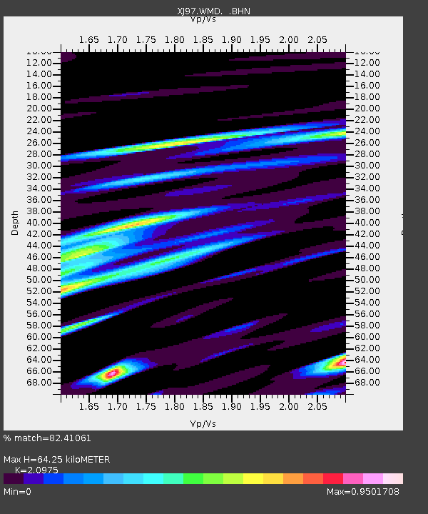
| Estimated Moho Depth: |
64.25 km |
| Estimated Crust Vp/Vs: |
2.10 |
| Assumed Crust Vp: |
6.291 km/s |
| Estimated Crust Vs: |
2.999 km/s |
| Estimated Crust Poisson's Ratio: |
0.35 |
|
| Radial Match: |
82.41061 % |
| Radial Bump: |
400 |
| Transverse Match: |
78.62985 % |
| Transverse Bump: |
400 |
| SOD ConfigId: |
6273 |
| Insert Time: |
2010-03-09 20:17:54.137 +0000 |
| GWidth: |
2.5 |
| Max Bumps: |
400 |
| Tol: |
0.001 |
|

Signal To Noise
| Channel | StoN | STA | LTA |
| XJ:WMD: :BHN:19970904T04:34:42.502014Z | 3.8414817 | 1.9228676E-7 | 5.0055363E-8 |
| XJ:WMD: :BHE:19970904T04:34:42.502014Z | 3.5765774 | 2.3963554E-7 | 6.700136E-8 |
| XJ:WMD: :BHZ:19970904T04:34:42.502014Z | 16.589706 | 9.69181E-7 | 5.842063E-8 |
| Arrivals |
| Ps | 11 SECOND |
| PpPs | 31 SECOND |
| PsPs/PpSs | 42 SECOND |


