
Station XJ WMD - White Meadow
Network: XJ97 - Sierran Paradox
Nearby stations (2 deg radius)
| Station | Name | (Lat, Lon) | Start / End | Elevation |
| WMD | White Meadow | (36.20, -118.58) | 1997-06-02 / 1997-12-31 | 2592 m |
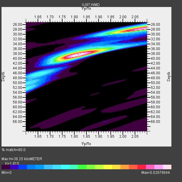
| Crust2 Type: | M9,thick extended crust, 0.5 km seds. |
| Thickness Estimate: | 38 km |
| Thickness StdDev: | 5.6 km |
| Vp/Vs Estimate: | 1.82 |
| Vp/Vs StdDev: | 0.13 |
| Vs Estimate: | 3.466 km/s |
| Poisson's Ratio: | 0.28 |
| Peak Value: | 0.03 |
| Assumed Vp: | 6.291 km/s |
| Ps Weight: | 0.33333334 |
| PpPs Weight: | 0.33333334 |
| PsPs Weight: | 0.33333328 |
| Residual Complexity: | 0.625 |
| Nearby stations H: | +- |
| (2.0 deg) Vp/Vs: | +- |
4 with match > 90% ( 22.222221 %) and 12 with match > 80% ( 66.666664 %) out of 18.
Download stack as xyz text file.
Azimuth Distribution of Events:

Prior Results for this Station
| Study | Thickness | Vp/Vs | Vp | Vs | Poissons Ratio | Extra |
| EARS | 38 km | 1.82 | 6.291 km/s | 3.466 km/s | 0.28 | |
| Crust2.0 | 40 km | 1.78 | 6.291 km/s | 3.539 km/s | 0.27 | M9,thick extended crust, 0.5 km seds. |
| Global Maxima | 38 km | 1.82 | 6.291 km/s | 3.466 km/s | 0.28 | amp=0.02879644 |
| Local Maxima 1 | 28 km | 2.09 | 6.291 km/s | 3.014 km/s | 0.35 | amp=0.026681684 |
| Local Maxima 2 | 40 km | 1.75 | 6.291 km/s | 3.585 km/s | 0.26 | amp=0.011871469 |
| Local Maxima 3 | 52 km | 1.61 | 6.291 km/s | 3.908 km/s | 0.19 | amp=0.009797277 |
| Local Maxima 4 | 26 km | 2.10 | 6.291 km/s | 2.999 km/s | 0.35 | amp=0.008392879 |
| Predicted Arrivals for vertical incidence (zero ray parameter) | |
| Ps | 4.96 SECOND |
| PpPs | 17.11 SECOND |
| PsPs/PpSs | 22.07 SECOND |
Events Processed for this Station
Download zip of receiver functions as SAC
Plot maxima for each earthquake.
Events Used in the Stack
(12 events)| Radial Match | Distance | Baz | FERegion | Time | Lat/Lon | Depth | Magnitude |
| 96.91188 | 55.8 deg | 102.791 deg | Near Coast Of Venezuela | 1997/07/09 19:24:13 GMT | (10.6, -63.5) | 20 km | 6.2 MB, 6.8 MS, 7.0 UNKNOWN, 6.6 ME |
| 94.63849 | 79.2 deg | 140.026 deg | Near Coast Of Central Chile | 1997/07/06 09:54:00 GMT | (-30.1, -71.9) | 19 km | 5.8 MB, 6.5 MS, 6.8 UNKNOWN, 6.4 ME |
| 92.95308 | 79.5 deg | 140.298 deg | Near Coast Of Central Chile | 1997/07/27 05:21:29 GMT | (-30.5, -71.9) | 33 km | 5.6 MB, 5.8 MS, 6.3 UNKNOWN, 6.2 MW |
| 92.28879 | 45.1 deg | 309.423 deg | Andreanof Islands, Aleutian Is. | 1997/06/17 21:03:40 GMT | (51.3, -179.3) | 33 km | 6.4 MB, 6.3 MS, 6.4 UNKNOWN, 6.6 ML |
| 89.84502 | 69.5 deg | 309.029 deg | Kuril Islands | 1997/07/14 16:09:35 GMT | (43.2, 146.4) | 33 km | 5.9 MB, 5.8 MS, 6.1 UNKNOWN, 5.8 ME |
| 87.74157 | 79.5 deg | 140.296 deg | Near Coast Of Central Chile | 1997/07/25 06:47:02 GMT | (-30.5, -71.9) | 33 km | 5.6 MB, 5.5 MS, 6.3 UNKNOWN |
| 87.3124 | 85.1 deg | 229.134 deg | Kermadec Islands Region | 1997/09/20 16:11:32 GMT | (-28.7, -177.6) | 30 km | 6.1 MB, 7.0 MS, 7.2 UNKNOWN, 6.7 ME |
| 86.79236 | 83.7 deg | 292.986 deg | Volcano Islands, Japan Region | 1997/07/28 06:46:55 GMT | (22.4, 142.7) | 33 km | 5.7 MB, 5.8 MS, 5.9 UNKNOWN, 5.9 MW |
| 84.93537 | 85.5 deg | 249.681 deg | Vanuatu Islands | 1997/08/17 20:11:10 GMT | (-13.6, 167.4) | 26 km | 5.4 MB, 6.1 MS, 6.1 UNKNOWN, 6.0 MW |
| 84.84668 | 42.1 deg | 160.65 deg | Central East Pacific Rise | 1997/08/15 07:37:49 GMT | (-4.4, -105.7) | 10 km | 5.3 MB, 5.8 MS, 6.2 UNKNOWN, 6.1 MW |
| 83.14477 | 37.8 deg | 311.337 deg | Fox Islands, Aleutian Islands | 1997/07/20 00:30:20 GMT | (52.6, -167.5) | 14 km | 5.6 MB, 5.9 MS, 6.2 UNKNOWN, 6.2 MW |
| 82.41061 | 86.2 deg | 233.165 deg | South Of Fiji Islands | 1997/09/04 04:23:37 GMT | (-26.6, 178.3) | 625 km | 6.3 MB, 6.8 UNKNOWN, 6.5 ME |
Losers
(6 events)| Radial Match | Distance | Baz | FERegion | Time | Lat/Lon | Depth | Magnitude | Reason |
| 70.46621 | 91.1 deg | 263.385 deg | Solomon Islands | 1997/09/07 12:57:06 GMT | (-6.0, 154.5) | 421 km | 5.6 MB, 5.8 UNKNOWN, 5.8 MW | |
| 66.16712 | 81.7 deg | 232.358 deg | South Of Fiji Islands | 1997/06/11 09:29:23 GMT | (-24.0, -177.5) | 164 km | 5.9 UNKNOWN, 5.4 MB, 5.5 MB | |
| 64.97715 | 94.0 deg | 304.938 deg | Southwestern Ryukyu Isl., Japan | 1997/08/13 04:45:04 GMT | (25.0, 125.8) | 55 km | 6.0 MB, 5.6 MS, 6.1 UNKNOWN, 6.1 MW | |
| 64.06052 | 96.4 deg | 306.806 deg | Taiwan Region | 1997/07/15 11:05:31 GMT | (24.7, 122.4) | 103 km | 5.6 MB, 5.6 UNKNOWN, 5.6 MW | |
| 61.719723 | 79.6 deg | 234.785 deg | Fiji Islands Region | 1997/08/25 11:59:00 GMT | (-20.8, -177.8) | 394 km | 5.5 UNKNOWN, 5.3 MB | |
| 61.153328 | 82.9 deg | 294.169 deg | Volcano Islands, Japan Region | 1997/07/08 02:24:07 GMT | (23.8, 142.7) | 33 km | 5.8 MB, 5.6 MS, 5.9 UNKNOWN, 5.8 MW |
