You are here: Home > Network List > XM99 - Rio Grande Seismic Transect Stations List
> Station NM19 NewMexico19 > Earthquake Result Viewer
NM19 NewMexico19 - Earthquake Result Viewer
| Earthquake location: |
Salta Province, Argentina |
| Earthquake latitude/longitude: |
-24.0/-66.7 |
| Earthquake time(UTC): |
2000/06/14 (166) 03:19:18 GMT |
| Earthquake Depth: |
196 km |
| Earthquake Magnitude: |
5.3 MB, 5.7 MW |
| Earthquake Catalog/Contributor: |
WHDF/NEIC |
|
| Network: |
XM Rio Grande Seismic Transect |
| Station: |
NM19 NewMexico19 |
| Lat/Lon: |
33.49 N/105.46 W |
| Elevation: |
2028 m |
|
| Distance: |
68.0 deg |
| Az: |
325.706 deg |
| Baz: |
141.941 deg |
| Ray Param: |
0.055999175 |
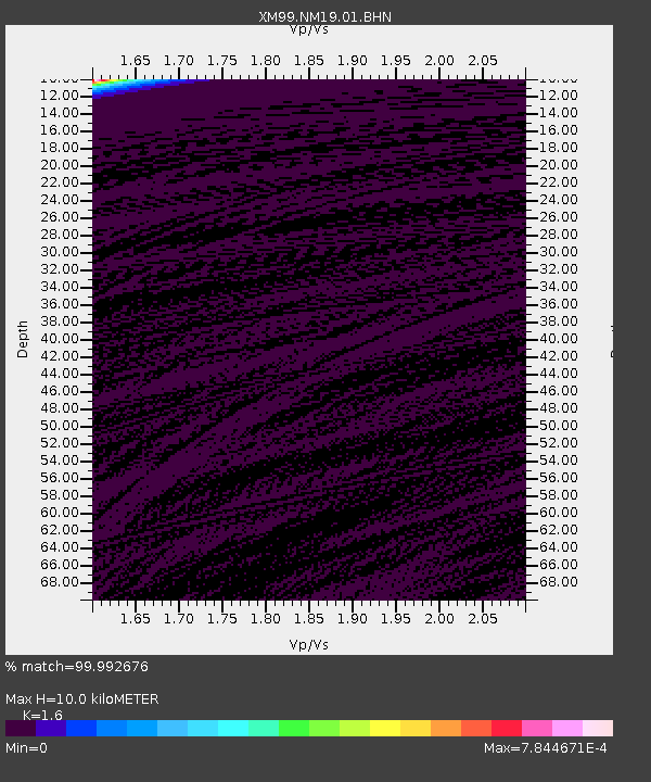
| Estimated Moho Depth: |
10.0 km |
| Estimated Crust Vp/Vs: |
1.60 |
| Assumed Crust Vp: |
6.232 km/s |
| Estimated Crust Vs: |
3.895 km/s |
| Estimated Crust Poisson's Ratio: |
0.18 |
|
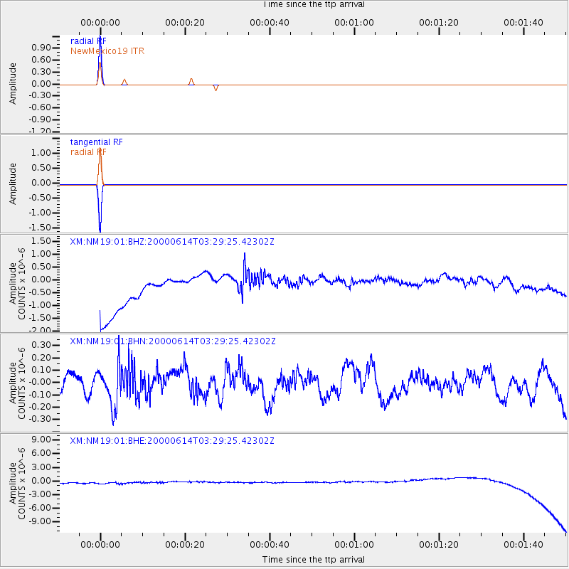
| Radial Match: |
99.992676 % |
| Radial Bump: |
2 |
| Transverse Match: |
99.99144 % |
| Transverse Bump: |
2 |
| SOD ConfigId: |
16820 |
| Insert Time: |
2010-02-26 17:26:25.618 +0000 |
| GWidth: |
2.5 |
| Max Bumps: |
400 |
| Tol: |
0.001 |
|
Signal To Noise
| Channel | StoN | STA | LTA |
| XM:NM19:01:BHN:20000614T03:29:25.42302Z | 1.8290777 | 1.6128482E-7 | 8.817822E-8 |
| XM:NM19:01:BHE:20000614T03:29:25.42302Z | 0.9924902 | 8.9934406E-7 | 9.0614907E-7 |
| XM:NM19:01:BHZ:20000614T03:29:25.42302Z | 1.0354406 | 6.550568E-7 | 6.326358E-7 |
| Arrivals |
| Ps | 1.0 SECOND |
| PpPs | 4.0 SECOND |
| PsPs/PpSs | 5.0 SECOND |


