
Station XM NM19 - NewMexico19
Network: XM99 - Rio Grande Seismic Transect
Nearby stations (2 deg radius)
| Station | Name | (Lat, Lon) | Start / End | Elevation |
| NM19 | NewMexico19 | (33.49, -105.46) | 1999-10-01 / 2001-12-31 | 2028 m |
| Crust2 Type: | P2,orogen/38km, Alps and Foreland, 2 km seds. |
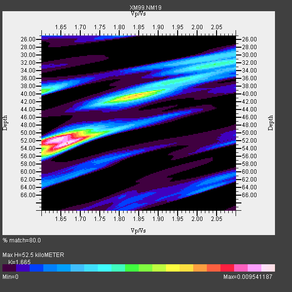
| Thickness Estimate: | 52 km |
| Thickness StdDev: | 5.3 km |
| Vp/Vs Estimate: | 1.66 |
| Vp/Vs StdDev: | 0.08 |
| Vs Estimate: | 3.743 km/s |
| Poisson's Ratio: | 0.22 |
| Peak Value: | 0.01 |
| Assumed Vp: | 6.232 km/s |
| Ps Weight: | 0.33333334 |
| PpPs Weight: | 0.33333334 |
| PsPs Weight: | 0.33333328 |
| Residual Complexity: | 0.756 |
| Nearby stations H: | +- |
| (2.0 deg) Vp/Vs: | +- |
7 with match > 90% ( 50.0 %) and 14 with match > 80% ( 100.0 %) out of 14.
Download stack as xyz text file.
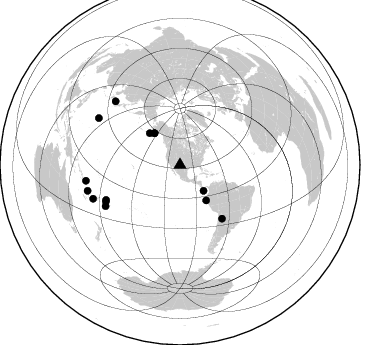
Azimuth Distribution of Events:
Prior Results for this Station
| Study | Thickness | Vp/Vs | Vp | Vs | Poissons Ratio | Extra |
| EARS | 52 km | 1.66 | 6.232 km/s | 3.743 km/s | 0.22 | |
| Crust2.0 | 38 km | 1.76 | 6.232 km/s | 3.534 km/s | 0.26 | P2,orogen/38km, Alps and Foreland, 2 km seds. |
| Wilson | 46 km | 1.76 | 6.26 km/s | 3.557 km/s | 0.26 | |
| Global Maxima | 52 km | 1.66 | 6.232 km/s | 3.743 km/s | 0.22 | amp=0.009541187 |
| Local Maxima 1 | 52 km | 1.63 | 6.232 km/s | 3.829 km/s | 0.20 | amp=0.007994212 |
| Local Maxima 2 | 40 km | 1.85 | 6.232 km/s | 3.364 km/s | 0.29 | amp=0.0063285017 |
| Local Maxima 3 | 39 km | 1.60 | 6.232 km/s | 3.895 km/s | 0.18 | amp=0.0052380767 |
| Local Maxima 4 | 36 km | 1.97 | 6.232 km/s | 3.171 km/s | 0.33 | amp=0.0030805345 |
| Predicted Arrivals for vertical incidence (zero ray parameter) | |
| Ps | 5.60 SECOND |
| PpPs | 22.45 SECOND |
| PsPs/PpSs | 28.05 SECOND |
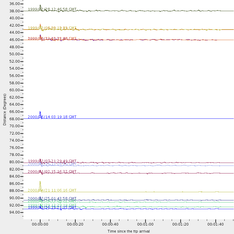
Events Processed for this Station
Download zip of receiver functions as SAC
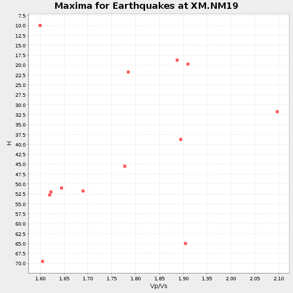
Plot maxima for each earthquake.
Events Used in the Stack
(14 events)| Radial Match | Distance | Baz | FERegion | Time | Lat/Lon | Depth | Magnitude |
| 99.992676 | 68.0 deg | 141.941 deg | Salta Province, Argentina | 2000/06/14 03:19:18 GMT | (-24.0, -66.7) | 196 km | 5.3 MB, 5.7 MW |
| 99.68868 | 90.7 deg | 314.617 deg | Western Honshu, Japan | 2000/04/21 11:06:16 GMT | (35.7, 135.5) | 346 km | 5.4 MB, 5.5 MW, 5.4 MW |
| 98.11847 | 93.9 deg | 299.843 deg | Volcano Islands, Japan Region | 2000/03/28 11:00:22 GMT | (22.3, 143.7) | 126 km | 6.8 MB, 7.6 MS, 7.6 MW, 7.6 MW |
| 96.35931 | 95.9 deg | 254.337 deg | Vanuatu Islands | 1999/11/26 13:21:15 GMT | (-16.4, 168.2) | 33 km | 6.4 MB, 7.3 MS, 7.5 MW, 7.3 MW |
| 95.74977 | 40.7 deg | 321.181 deg | Kodiak Island Region, Alaska | 1999/12/06 23:12:33 GMT | (57.4, -154.5) | 66 km | 6.8 MB, 7.0 MW, 7.0 ML |
| 93.1793 | 93.2 deg | 248.795 deg | Vanuatu Islands Region | 2000/02/25 01:43:58 GMT | (-19.5, 173.8) | 33 km | 6.1 MB, 7.1 MS, 7.1 MW, 7.0 MW |
| 92.19205 | 84.9 deg | 241.146 deg | Tonga Islands | 2000/01/02 15:16:32 GMT | (-20.8, -174.2) | 33 km | 5.5 MB, 5.8 MS, 5.8 MW, 5.8 MW |
| 89.71746 | 82.5 deg | 243.75 deg | Tonga Islands | 2000/01/26 13:26:50 GMT | (-17.3, -174.0) | 33 km | 5.9 MB, 6.0 MS, 6.4 MW, 6.3 MW |
| 87.632774 | 43.9 deg | 316.182 deg | Alaska Peninsula | 1999/10/13 01:33:40 GMT | (54.7, -161.2) | 30 km | 6.0 MB, 6.2 MS, 6.5 MW, 6.0 ML |
| 86.52096 | 81.7 deg | 244.812 deg | Tonga Islands | 1999/12/07 21:29:49 GMT | (-15.9, -174.0) | 138 km | 6.2 MB, 6.4 MW, 6.4 MW |
| 83.890396 | 40.7 deg | 321.1 deg | Kodiak Island Region, Alaska | 1999/12/07 00:19:49 GMT | (57.4, -154.5) | 41 km | 6.5 MB, 6.1 MS, 6.4 MW, 6.3 ML |
| 83.61342 | 95.2 deg | 260.518 deg | Santa Cruz Islands | 1999/12/29 13:29:19 GMT | (-10.9, 165.4) | 33 km | 5.6 MB, 6.8 MS, 6.8 MW, 6.3 MW |
| 83.07632 | 43.9 deg | 143.616 deg | Near Coast Of Northern Peru | 2000/05/22 13:15:08 GMT | (-4.1, -81.1) | 33 km | 5.3 MB, 5.4 MS, 5.8 MW, 5.8 MW |
| 83.069885 | 34.9 deg | 137.613 deg | South Of Panama | 1999/12/28 12:46:58 GMT | (5.6, -82.6) | 10 km | 5.4 MB, 5.5 MS, 5.9 MW, 5.5 ML |
Losers
(0 events)| Radial Match | Distance | Baz | FERegion | Time | Lat/Lon | Depth | Magnitude | Reason |
