You are here: Home > Network List > XM99 - Rio Grande Seismic Transect Stations List
> Station NM19 NewMexico19 > Earthquake Result Viewer
NM19 NewMexico19 - Earthquake Result Viewer
| Earthquake location: |
Western Honshu, Japan |
| Earthquake latitude/longitude: |
35.7/135.5 |
| Earthquake time(UTC): |
2000/04/21 (112) 11:06:16 GMT |
| Earthquake Depth: |
346 km |
| Earthquake Magnitude: |
5.4 MB, 5.5 MW, 5.4 MW |
| Earthquake Catalog/Contributor: |
WHDF/NEIC |
|
| Network: |
XM Rio Grande Seismic Transect |
| Station: |
NM19 NewMexico19 |
| Lat/Lon: |
33.49 N/105.46 W |
| Elevation: |
2028 m |
|
| Distance: |
90.7 deg |
| Az: |
46.931 deg |
| Baz: |
314.617 deg |
| Ray Param: |
0.041550167 |
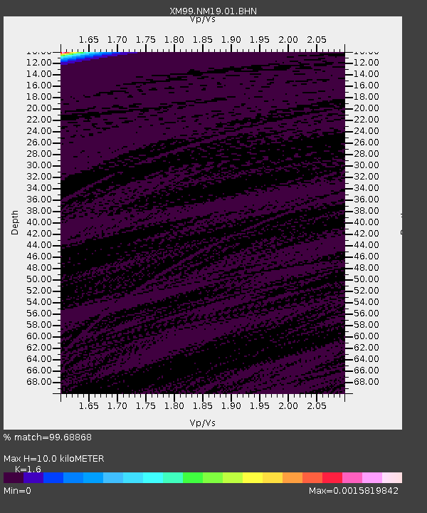
| Estimated Moho Depth: |
10.0 km |
| Estimated Crust Vp/Vs: |
1.60 |
| Assumed Crust Vp: |
6.232 km/s |
| Estimated Crust Vs: |
3.895 km/s |
| Estimated Crust Poisson's Ratio: |
0.18 |
|
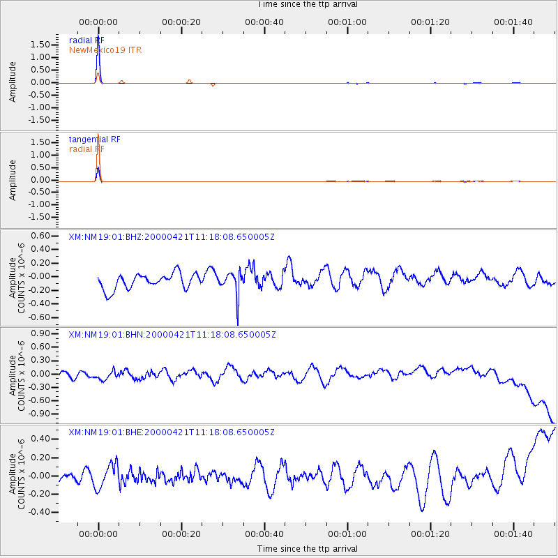
| Radial Match: |
99.68868 % |
| Radial Bump: |
30 |
| Transverse Match: |
98.3668 % |
| Transverse Bump: |
53 |
| SOD ConfigId: |
16820 |
| Insert Time: |
2010-02-26 17:26:28.496 +0000 |
| GWidth: |
2.5 |
| Max Bumps: |
400 |
| Tol: |
0.001 |
|
Signal To Noise
| Channel | StoN | STA | LTA |
| XM:NM19:01:BHN:20000421T11:18:08.650005Z | 0.99199194 | 1.3940641E-7 | 1.405318E-7 |
| XM:NM19:01:BHE:20000421T11:18:08.650005Z | 1.298204 | 1.3848232E-7 | 1.0667224E-7 |
| XM:NM19:01:BHZ:20000421T11:18:08.650005Z | 1.5119863 | 1.6901521E-7 | 1.1178356E-7 |
| Arrivals |
| Ps | 1.0 SECOND |
| PpPs | 4.1 SECOND |
| PsPs/PpSs | 5.1 SECOND |


