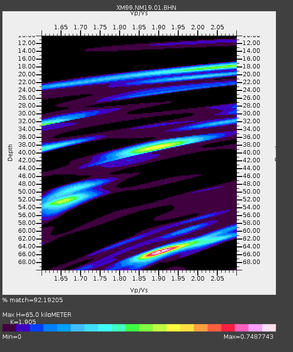
NM19 NewMexico19 - Earthquake Result Viewer
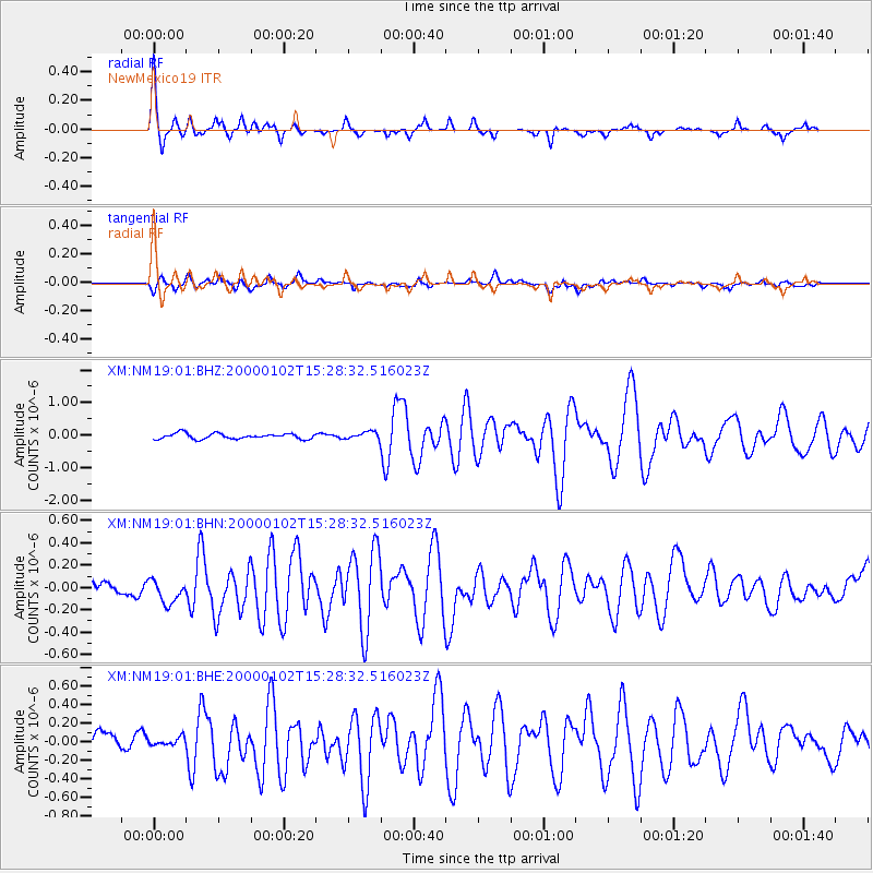
Earthquake location: Tonga Islands
Earthquake latitude/longitude: -20.8/-174.2
Earthquake time(UTC): 2000/01/02 (002) 15:16:32 GMT
Earthquake Depth: 33 km
Earthquake Magnitude: 5.5 MB, 5.8 MS, 5.8 MW, 5.8 MW
Earthquake Catalog/Contributor: WHDF/NEIC
Network: XM Rio Grande Seismic Transect
Station: NM19 NewMexico19
Lat/Lon: 33.49 N/105.46 W
Elevation: 2028 m
Distance: 84.9 deg
Az: 51.457 deg
Baz: 241.146 deg
Ray Param: 0.045128543
Estimated Moho Depth: 65.0 km
Estimated Crust Vp/Vs: 1.90
Assumed Crust Vp: 6.232 km/s
Estimated Crust Vs: 3.271 km/s
Estimated Crust Poisson's Ratio: 0.31
Radial Match: 92.19205 %
Radial Bump: 316
Transverse Match: 64.1409 %
Transverse Bump: 400
SOD ConfigId: 16820
Insert Time: 2010-02-26 17:26:29.630 +0000
GWidth: 2.5
Max Bumps: 400
Tol: 0.001

Signal To Noise

ChannelStoNSTALTA
XM:NM19:01:BHN:20000102T15:28:32.516023Z0.83112081.06254625E-71.2784498E-7
XM:NM19:01:BHE:20000102T15:28:32.516023Z0.371480144.359038E-81.17342424E-7
XM:NM19:01:BHZ:20000102T15:28:32.516023Z1.32253021.1082552E-78.37981E-8
Arrivals
Ps9.6 SECOND
PpPs30 SECOND
PsPs/PpSs39 SECOND