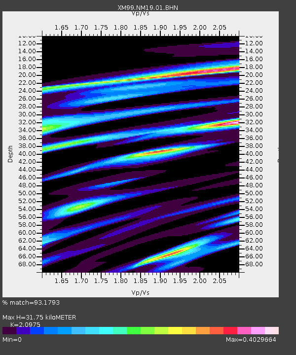
NM19 NewMexico19 - Earthquake Result Viewer
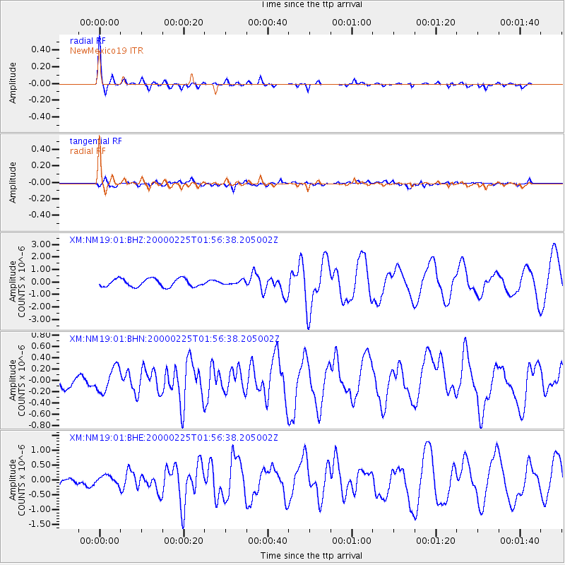
Earthquake location: Vanuatu Islands Region
Earthquake latitude/longitude: -19.5/173.8
Earthquake time(UTC): 2000/02/25 (056) 01:43:58 GMT
Earthquake Depth: 33 km
Earthquake Magnitude: 6.1 MB, 7.1 MS, 7.1 MW, 7.0 MW
Earthquake Catalog/Contributor: WHDF/NEIC
Network: XM Rio Grande Seismic Transect
Station: NM19 NewMexico19
Lat/Lon: 33.49 N/105.46 W
Elevation: 2028 m
Distance: 93.2 deg
Az: 55.692 deg
Baz: 248.795 deg
Ray Param: 0.041300695
Estimated Moho Depth: 31.75 km
Estimated Crust Vp/Vs: 2.10
Assumed Crust Vp: 6.232 km/s
Estimated Crust Vs: 2.971 km/s
Estimated Crust Poisson's Ratio: 0.35
Radial Match: 93.1793 %
Radial Bump: 288
Transverse Match: 66.59365 %
Transverse Bump: 400
SOD ConfigId: 3744
Insert Time: 2010-02-26 17:26:31.922 +0000
GWidth: 2.5
Max Bumps: 400
Tol: 0.001

Signal To Noise

ChannelStoNSTALTA
XM:NM19:01:BHN:20000225T01:56:38.205002Z2.73915312.1882796E-77.9888906E-8
XM:NM19:01:BHE:20000225T01:56:38.205002Z1.34818361.4478931E-71.0739584E-7
XM:NM19:01:BHZ:20000225T01:56:38.205002Z0.488955681.545867E-73.1615687E-7
Arrivals
Ps5.7 SECOND
PpPs16 SECOND
PsPs/PpSs21 SECOND