You are here: Home > Network List > XM99 - Rio Grande Seismic Transect Stations List
> Station NM19 NewMexico19 > Earthquake Result Viewer
NM19 NewMexico19 - Earthquake Result Viewer
| Earthquake location: |
Kodiak Island Region, Alaska |
| Earthquake latitude/longitude: |
57.4/-154.5 |
| Earthquake time(UTC): |
1999/12/06 (340) 23:12:33 GMT |
| Earthquake Depth: |
66 km |
| Earthquake Magnitude: |
6.8 MB, 7.0 MW, 7.0 ML |
| Earthquake Catalog/Contributor: |
WHDF/NEIC |
|
| Network: |
XM Rio Grande Seismic Transect |
| Station: |
NM19 NewMexico19 |
| Lat/Lon: |
33.49 N/105.46 W |
| Elevation: |
2028 m |
|
| Distance: |
40.7 deg |
| Az: |
104.527 deg |
| Baz: |
321.181 deg |
| Ray Param: |
0.0740591 |
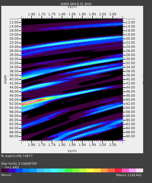
| Estimated Moho Depth: |
51.0 km |
| Estimated Crust Vp/Vs: |
1.64 |
| Assumed Crust Vp: |
6.232 km/s |
| Estimated Crust Vs: |
3.788 km/s |
| Estimated Crust Poisson's Ratio: |
0.21 |
|
| Radial Match: |
95.74977 % |
| Radial Bump: |
305 |
| Transverse Match: |
85.545715 % |
| Transverse Bump: |
400 |
| SOD ConfigId: |
27569 |
| Insert Time: |
2010-02-26 17:26:37.730 +0000 |
| GWidth: |
2.5 |
| Max Bumps: |
400 |
| Tol: |
0.001 |
|
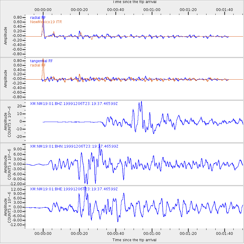
Signal To Noise
| Channel | StoN | STA | LTA |
| XM:NM19:01:BHN:19991206T23:19:37.46599Z | 6.8427906 | 1.1626872E-6 | 1.6991419E-7 |
| XM:NM19:01:BHE:19991206T23:19:37.46599Z | 7.841752 | 1.2175161E-6 | 1.5526072E-7 |
| XM:NM19:01:BHZ:19991206T23:19:37.46599Z | 23.14525 | 2.5824604E-6 | 1.11576256E-7 |
| Arrivals |
| Ps | 5.7 SECOND |
| PpPs | 20 SECOND |
| PsPs/PpSs | 26 SECOND |


