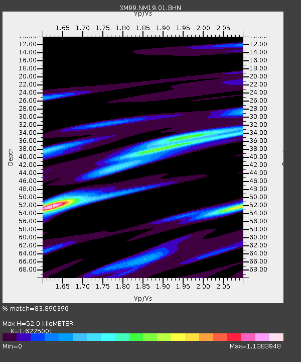
NM19 NewMexico19 - Earthquake Result Viewer
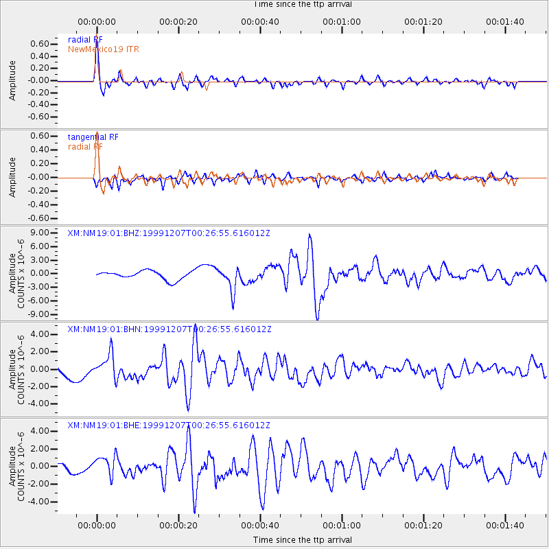
Earthquake location: Kodiak Island Region, Alaska
Earthquake latitude/longitude: 57.4/-154.5
Earthquake time(UTC): 1999/12/07 (341) 00:19:49 GMT
Earthquake Depth: 41 km
Earthquake Magnitude: 6.5 MB, 6.1 MS, 6.4 MW, 6.3 ML
Earthquake Catalog/Contributor: WHDF/NEIC
Network: XM Rio Grande Seismic Transect
Station: NM19 NewMexico19
Lat/Lon: 33.49 N/105.46 W
Elevation: 2028 m
Distance: 40.7 deg
Az: 104.445 deg
Baz: 321.1 deg
Ray Param: 0.07416308
Estimated Moho Depth: 52.0 km
Estimated Crust Vp/Vs: 1.62
Assumed Crust Vp: 6.232 km/s
Estimated Crust Vs: 3.841 km/s
Estimated Crust Poisson's Ratio: 0.19
Radial Match: 83.890396 %
Radial Bump: 376
Transverse Match: 67.61773 %
Transverse Bump: 400
SOD ConfigId: 27569
Insert Time: 2010-02-26 17:26:38.825 +0000
GWidth: 2.5
Max Bumps: 400
Tol: 0.001

Signal To Noise

ChannelStoNSTALTA
XM:NM19:01:BHN:19991207T00:26:55.616012Z1.68947941.4618993E-68.6529576E-7
XM:NM19:01:BHE:19991207T00:26:55.616012Z1.92633021.1798718E-66.124972E-7
XM:NM19:01:BHZ:19991207T00:26:55.616012Z2.71859462.6604027E-69.785948E-7
Arrivals
Ps5.6 SECOND
PpPs20 SECOND
PsPs/PpSs26 SECOND