You are here: Home > Network List > XM99 - Rio Grande Seismic Transect Stations List
> Station NM19 NewMexico19 > Earthquake Result Viewer
NM19 NewMexico19 - Earthquake Result Viewer
| Earthquake location: |
Tonga Islands |
| Earthquake latitude/longitude: |
-15.9/-174.0 |
| Earthquake time(UTC): |
1999/12/07 (341) 21:29:49 GMT |
| Earthquake Depth: |
138 km |
| Earthquake Magnitude: |
6.2 MB, 6.4 MW, 6.4 MW |
| Earthquake Catalog/Contributor: |
WHDF/NEIC |
|
| Network: |
XM Rio Grande Seismic Transect |
| Station: |
NM19 NewMexico19 |
| Lat/Lon: |
33.49 N/105.46 W |
| Elevation: |
2028 m |
|
| Distance: |
81.7 deg |
| Az: |
51.808 deg |
| Baz: |
244.812 deg |
| Ray Param: |
0.047093406 |
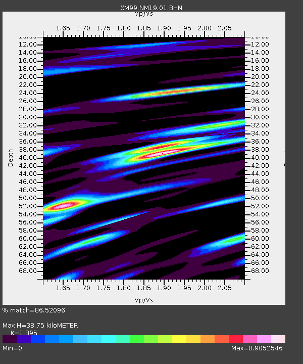
| Estimated Moho Depth: |
38.75 km |
| Estimated Crust Vp/Vs: |
1.89 |
| Assumed Crust Vp: |
6.232 km/s |
| Estimated Crust Vs: |
3.288 km/s |
| Estimated Crust Poisson's Ratio: |
0.31 |
|
| Radial Match: |
86.52096 % |
| Radial Bump: |
400 |
| Transverse Match: |
58.838345 % |
| Transverse Bump: |
400 |
| SOD ConfigId: |
27569 |
| Insert Time: |
2010-02-26 17:26:39.912 +0000 |
| GWidth: |
2.5 |
| Max Bumps: |
400 |
| Tol: |
0.001 |
|
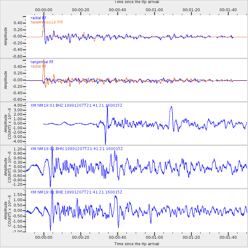
Signal To Noise
| Channel | StoN | STA | LTA |
| XM:NM19:01:BHN:19991207T21:41:21.160015Z | 4.572978 | 6.0050826E-7 | 1.3131668E-7 |
| XM:NM19:01:BHE:19991207T21:41:21.160015Z | 5.455707 | 7.705275E-7 | 1.412333E-7 |
| XM:NM19:01:BHZ:19991207T21:41:21.160015Z | 9.808841 | 1.5060751E-6 | 1.5354263E-7 |
| Arrivals |
| Ps | 5.7 SECOND |
| PpPs | 18 SECOND |
| PsPs/PpSs | 23 SECOND |


