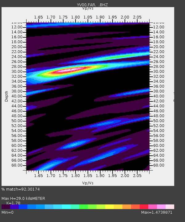
FAR Faroes - Earthquake Result Viewer

Earthquake location: Near Coast Of Peru
Earthquake latitude/longitude: -16.3/-73.6
Earthquake time(UTC): 2001/06/23 (174) 20:33:14 GMT
Earthquake Depth: 33 km
Earthquake Magnitude: 6.7 MB, 8.2 MS, 8.4 MW, 7.8 ME
Earthquake Catalog/Contributor: WHDF/NEIC
Network: YV North East Atlantic Tomography (NEAT)
Station: FAR Faroes
Lat/Lon: 62.03 N/6.79 W
Elevation: 20 m
Distance: 93.9 deg
Az: 25.749 deg
Baz: 242.268 deg
Ray Param: 0.041162815
Estimated Moho Depth: 29.0 km
Estimated Crust Vp/Vs: 1.78
Assumed Crust Vp: 6.156 km/s
Estimated Crust Vs: 3.458 km/s
Estimated Crust Poisson's Ratio: 0.27
Radial Match: 92.30174 %
Radial Bump: 350
Transverse Match: 79.37489 %
Transverse Bump: 400
SOD ConfigId: 16820
Insert Time: 2010-03-09 20:39:35.458 +0000
GWidth: 2.5
Max Bumps: 400
Tol: 0.001

Signal To Noise

ChannelStoNSTALTA
YV:FAR: :BHZ:20010623T20:45:56.799006Z1.1673012.018968E-71.7296034E-7
YV:FAR: :BHN:20010623T20:45:56.799006Z2.05479454.1302124E-72.0100366E-7
YV:FAR: :BHE:20010623T20:45:56.799006Z6.2897822.1638855E-63.440319E-7
Arrivals
Ps3.7 SECOND
PpPs13 SECOND
PsPs/PpSs17 SECOND