
Station YV FAR - Faroes
Network: YV00 - North East Atlantic Tomography (NEAT)
Nearby stations (2 deg radius)
| Station | Name | (Lat, Lon) | Start / End | Elevation |
| FAR | Faroes | (62.03, -6.79) | 2001-04-27 / 2003-06-09 | 20 m |
| Crust2 Type: | W2,oceanic plateau with cont. crust, 1 km seds. |
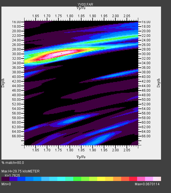
| Thickness Estimate: | 30 km |
| Thickness StdDev: | 1.6 km |
| Vp/Vs Estimate: | 1.76 |
| Vp/Vs StdDev: | 0.05 |
| Vs Estimate: | 3.493 km/s |
| Poisson's Ratio: | 0.26 |
| Peak Value: | 0.07 |
| Assumed Vp: | 6.156 km/s |
| Ps Weight: | 0.33333334 |
| PpPs Weight: | 0.33333334 |
| PsPs Weight: | 0.33333328 |
| Residual Complexity: | 0.554 |
| Nearby stations H: | +- |
| (2.0 deg) Vp/Vs: | +- |
3 with match > 90% ( 100.0 %) and 3 with match > 80% ( 100.0 %) out of 3.
Download stack as xyz text file.
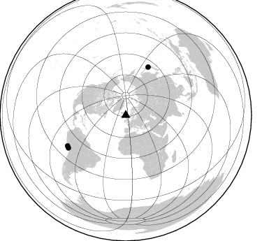
Azimuth Distribution of Events:
Prior Results for this Station
| Study | Thickness | Vp/Vs | Vp | Vs | Poissons Ratio | Extra |
| EARS | 30 km | 1.76 | 6.156 km/s | 3.493 km/s | 0.26 | |
| Crust2.0 | 20 km | 1.81 | 6.156 km/s | 3.4 km/s | 0.28 | W2,oceanic plateau with cont. crust, 1 km seds. |
| Global Maxima | 30 km | 1.76 | 6.156 km/s | 3.493 km/s | 0.26 | amp=0.0670114 |
| Local Maxima 1 | 33 km | 1.67 | 6.156 km/s | 3.692 km/s | 0.22 | amp=0.04409564 |
| Local Maxima 2 | 22 km | 2.05 | 6.156 km/s | 3.003 km/s | 0.34 | amp=0.029895695 |
| Local Maxima 3 | 29 km | 1.67 | 6.156 km/s | 3.681 km/s | 0.22 | amp=0.024390588 |
| Local Maxima 4 | 28 km | 1.81 | 6.156 km/s | 3.396 km/s | 0.28 | amp=0.016265256 |
| Predicted Arrivals for vertical incidence (zero ray parameter) | |
| Ps | 3.68 SECOND |
| PpPs | 13.35 SECOND |
| PsPs/PpSs | 17.03 SECOND |
Events Processed for this Station
Download zip of receiver functions as SAC
Plot maxima for each earthquake.
Events Used in the Stack
(3 events)| Radial Match | Distance | Baz | FERegion | Time | Lat/Lon | Depth | Magnitude |
| 97.625595 | 76.3 deg | 24.939 deg | Near East Coast Of Honshu, Japan | 2003/05/26 09:24:33 GMT | (38.8, 141.6) | 68 km | 6.7 MB, 7.0 MW, 7.0 MW |
| 92.58 | 94.4 deg | 240.363 deg | Near Coast Of Peru | 2001/07/07 09:38:43 GMT | (-17.5, -72.1) | 33 km | 6.6 MB, 7.3 MS, 7.6 MW, 7.5 ME |
| 92.30174 | 93.9 deg | 242.268 deg | Near Coast Of Peru | 2001/06/23 20:33:14 GMT | (-16.3, -73.6) | 33 km | 6.7 MB, 8.2 MS, 8.4 MW, 7.8 ME |
Losers
(0 events)| Radial Match | Distance | Baz | FERegion | Time | Lat/Lon | Depth | Magnitude | Reason |
