You are here: Home > Network List > YV00 - North East Atlantic Tomography (NEAT) Stations List
> Station MOL Molde > Earthquake Result Viewer
MOL Molde - Earthquake Result Viewer
| Earthquake location: |
Colombia |
| Earthquake latitude/longitude: |
3.9/-76.0 |
| Earthquake time(UTC): |
2001/09/22 (265) 03:23:38 GMT |
| Earthquake Depth: |
179 km |
| Earthquake Magnitude: |
6.0 MB, 6.0 MW, 6.0 MW |
| Earthquake Catalog/Contributor: |
WHDF/NEIC |
|
| Network: |
YV North East Atlantic Tomography (NEAT) |
| Station: |
MOL Molde |
| Lat/Lon: |
62.57 N/7.55 E |
| Elevation: |
0.0 m |
|
| Distance: |
83.6 deg |
| Az: |
27.583 deg |
| Baz: |
266.03 deg |
| Ray Param: |
0.045658994 |
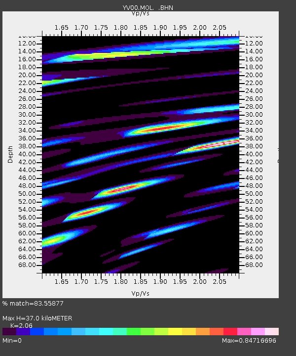
| Estimated Moho Depth: |
37.0 km |
| Estimated Crust Vp/Vs: |
2.06 |
| Assumed Crust Vp: |
6.391 km/s |
| Estimated Crust Vs: |
3.102 km/s |
| Estimated Crust Poisson's Ratio: |
0.35 |
|
| Radial Match: |
83.55877 % |
| Radial Bump: |
400 |
| Transverse Match: |
67.60154 % |
| Transverse Bump: |
400 |
| SOD ConfigId: |
16820 |
| Insert Time: |
2010-03-09 20:40:42.589 +0000 |
| GWidth: |
2.5 |
| Max Bumps: |
400 |
| Tol: |
0.001 |
|

Signal To Noise
| Channel | StoN | STA | LTA |
| YV:MOL: :BHN:20010922T03:35:15.196013Z | 1.6048838 | 3.954398E-7 | 2.4639778E-7 |
| YV:MOL: :BHE:20010922T03:35:15.196013Z | 8.349513 | 1.3633521E-6 | 1.6328522E-7 |
| YV:MOL: :BHZ:20010922T03:35:15.196013Z | 13.68799 | 2.8322838E-6 | 2.0691743E-7 |
| Arrivals |
| Ps | 6.3 SECOND |
| PpPs | 17 SECOND |
| PsPs/PpSs | 24 SECOND |


