
Station YV MOL - Molde
Network: YV00 - North East Atlantic Tomography (NEAT)
Nearby stations (2 deg radius)

| Station | Name | (Lat, Lon) | Start / End | Elevation |
| MOL | Molde | (62.57, 7.55) | 2000-11-01 / 2003-05-04 | 0.0 km |
| Crust2 Type: | T4,Margin /shield transition, East Siberia, 2 km seds. |
| Thickness Estimate: | 32 km |
| Thickness StdDev: | 4.5 km |
| Vp/Vs Estimate: | 1.90 |
| Vp/Vs StdDev: | 0.08 |
| Vs Estimate: | 3.363 km/s |
| Poisson's Ratio: | 0.31 |
| Peak Value: | 0.02 |
| Assumed Vp: | 6.391 km/s |
| Ps Weight: | 0.33333334 |
| PpPs Weight: | 0.33333334 |
| PsPs Weight: | 0.33333328 |
| Residual Complexity: | 0.636 |
| Nearby stations H: | +- |
| (2.0 deg) Vp/Vs: | +- |
1 with match > 90% ( 14.285714 %) and 7 with match > 80% ( 100.0 %) out of 7.
Download stack as xyz text file.
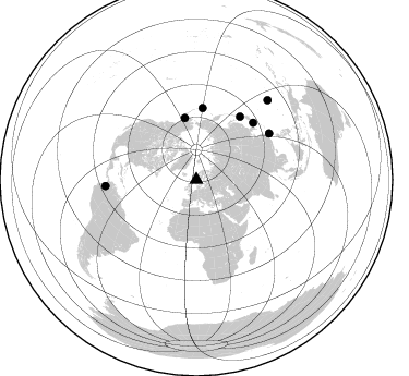
Azimuth Distribution of Events:
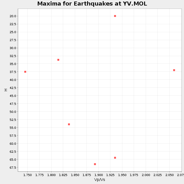
Prior Results for this Station
| Study | Thickness | Vp/Vs | Vp | Vs | Poissons Ratio | Extra |
| EARS | 32 km | 1.90 | 6.391 km/s | 3.363 km/s | 0.31 | |
| Crust2.0 | 32 km | 1.79 | 6.391 km/s | 3.572 km/s | 0.27 | T4,Margin /shield transition, East Siberia, 2 km seds. |
| Global Maxima | 32 km | 1.90 | 6.391 km/s | 3.363 km/s | 0.31 | amp=0.023710255 |
| Local Maxima 1 | 40 km | 1.72 | 6.391 km/s | 3.71 km/s | 0.25 | amp=0.017855022 |
| Local Maxima 2 | 42 km | 1.68 | 6.391 km/s | 3.81 km/s | 0.22 | amp=0.012672452 |
| Local Maxima 3 | 52 km | 1.90 | 6.391 km/s | 3.355 km/s | 0.31 | amp=0.006748319 |
| Local Maxima 4 | 52 km | 1.60 | 6.391 km/s | 3.994 km/s | 0.18 | amp=0.0062098415 |
| Predicted Arrivals for vertical incidence (zero ray parameter) | |
| Ps | 4.44 SECOND |
| PpPs | 14.29 SECOND |
| PsPs/PpSs | 18.73 SECOND |
Events Processed for this Station
Download zip of receiver functions as SAC
Plot maxima for each earthquake.
Events Used in the Stack
(7 events)| Radial Match | Distance | Baz | FERegion | Time | Lat/Lon | Depth | Magnitude |
| 95.867516 | 79.3 deg | 57.598 deg | Taiwan Region | 2002/03/31 06:52:50 GMT | (24.3, 122.2) | 33 km | 6.4 MB, 7.4 MS, 7.1 MW, 7.1 MW |
| 89.47394 | 70.5 deg | 34.721 deg | Hokkaido, Japan Region | 2001/08/13 20:11:23 GMT | (41.0, 142.3) | 38 km | 6.0 MB, 6.3 MS, 6.4 MW, 6.3 ME |
| 84.241585 | 74.1 deg | 45.0 deg | Western Honshu, Japan | 2001/03/24 06:27:53 GMT | (34.1, 132.5) | 50 km | 6.4 MB, 6.5 MS, 6.8 MW, 6.4 ME |
| 84.048325 | 98.0 deg | 41.81 deg | South Of Mariana Islands | 2001/10/12 15:02:16 GMT | (12.7, 145.0) | 37 km | 6.7 MB, 7.3 MS, 7.0 MW, 6.9 MW |
| 83.55877 | 83.6 deg | 266.03 deg | Colombia | 2001/09/22 03:23:38 GMT | (3.9, -76.0) | 179 km | 6.0 MB, 6.0 MW, 6.0 MW |
| 80.56844 | 58.0 deg | 349.529 deg | Southern Alaska | 2001/07/28 07:32:43 GMT | (59.0, -155.1) | 131 km | 5.7 MB, 5.7 MS, 6.6 MW, 6.2 ME |
| 80.265015 | 66.5 deg | 5.058 deg | Andreanof Islands, Aleutian Is. | 2001/06/14 19:48:47 GMT | (51.2, -179.8) | 18 km | 6.0 MB, 6.3 MS, 6.5 MW, 6.1 ML |
Losers
(0 events)| Radial Match | Distance | Baz | FERegion | Time | Lat/Lon | Depth | Magnitude | Reason |
