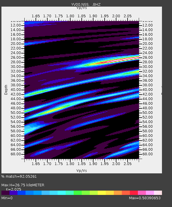
NSS Namsos - Earthquake Result Viewer

Earthquake location: Western Iran
Earthquake latitude/longitude: 35.6/49.0
Earthquake time(UTC): 2002/06/22 (173) 02:58:21 GMT
Earthquake Depth: 10 km
Earthquake Magnitude: 6.2 MB, 6.4 MS, 6.5 MW, 6.5 MW
Earthquake Catalog/Contributor: WHDF/NEIC
Network: YV North East Atlantic Tomography (NEAT)
Station: NSS Namsos
Lat/Lon: 64.53 N/11.97 E
Elevation: 0.0 m
Distance: 36.5 deg
Az: 334.002 deg
Baz: 124.319 deg
Ray Param: 0.07665044
Estimated Moho Depth: 26.75 km
Estimated Crust Vp/Vs: 2.03
Assumed Crust Vp: 6.472 km/s
Estimated Crust Vs: 3.196 km/s
Estimated Crust Poisson's Ratio: 0.34
Radial Match: 92.05261 %
Radial Bump: 314
Transverse Match: 65.32966 %
Transverse Bump: 400
SOD ConfigId: 16820
Insert Time: 2010-03-09 20:41:27.545 +0000
GWidth: 2.5
Max Bumps: 400
Tol: 0.001

Signal To Noise

ChannelStoNSTALTA
YV:NSS: :BHZ:20020622T03:04:55.780011Z4.4646313.470257E-77.772774E-8
YV:NSS: :BHN:20020622T03:04:55.780011Z3.46894363.1535845E-79.0909076E-8
YV:NSS: :BHE:20020622T03:04:55.780011Z5.9047586.950967E-71.17718066E-7
Arrivals
Ps4.5 SECOND
PpPs12 SECOND
PsPs/PpSs16 SECOND