
Station YV NSS - Namsos
Network: YV00 - North East Atlantic Tomography (NEAT)
Nearby stations (2 deg radius)
| Station | Name | (Lat, Lon) | Start / End | Elevation |
| NSS | Namsos | (64.53, 11.97) | 2001-10-24 / 2003-08-02 | 0.0 m |
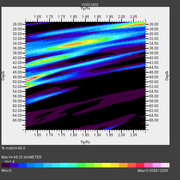
| Crust2 Type: | T6,Margin /shield transition, 1 km seds. |
| Thickness Estimate: | 49 km |
| Thickness StdDev: | 8.4 km |
| Vp/Vs Estimate: | 1.60 |
| Vp/Vs StdDev: | 0.17 |
| Vs Estimate: | 4.045 km/s |
| Poisson's Ratio: | 0.18 |
| Peak Value: | 0.01 |
| Assumed Vp: | 6.472 km/s |
| Ps Weight: | 0.33333334 |
| PpPs Weight: | 0.33333334 |
| PsPs Weight: | 0.33333328 |
| Residual Complexity: | 0.888 |
| Nearby stations H: | +- |
| (2.0 deg) Vp/Vs: | +- |
4 with match > 90% ( 15.384615 %) and 8 with match > 80% ( 30.76923 %) out of 26.
Download stack as xyz text file.
Azimuth Distribution of Events:

Prior Results for this Station
| Study | Thickness | Vp/Vs | Vp | Vs | Poissons Ratio | Extra |
| EARS | 49 km | 1.60 | 6.472 km/s | 4.045 km/s | 0.18 | |
| Crust2.0 | 32 km | 1.79 | 6.472 km/s | 3.622 km/s | 0.27 | T6,Margin /shield transition, 1 km seds. |
| Global Maxima | 49 km | 1.60 | 6.472 km/s | 4.045 km/s | 0.18 | amp=0.009612095 |
| Local Maxima 1 | 26 km | 2.10 | 6.472 km/s | 3.086 km/s | 0.35 | amp=0.007268156 |
| Local Maxima 2 | 34 km | 1.78 | 6.472 km/s | 3.641 km/s | 0.27 | amp=0.0064549292 |
| Local Maxima 3 | 52 km | 1.60 | 6.472 km/s | 4.039 km/s | 0.18 | amp=0.006073386 |
| Local Maxima 4 | 42 km | 1.63 | 6.472 km/s | 3.977 km/s | 0.20 | amp=0.0043209544 |
| Predicted Arrivals for vertical incidence (zero ray parameter) | |
| Ps | 4.57 SECOND |
| PpPs | 19.79 SECOND |
| PsPs/PpSs | 24.35 SECOND |
Events Processed for this Station
Download zip of receiver functions as SAC
Plot maxima for each earthquake.
Events Used in the Stack
(8 events)| Radial Match | Distance | Baz | FERegion | Time | Lat/Lon | Depth | Magnitude |
| 96.10093 | 69.6 deg | 39.925 deg | Near East Coast Of Honshu, Japan | 2003/05/26 09:24:33 GMT | (38.8, 141.6) | 68 km | 6.7 MB, 7.0 MW, 7.0 MW |
| 93.94076 | 76.6 deg | 61.701 deg | Taiwan Region | 2002/03/31 06:52:50 GMT | (24.3, 122.2) | 33 km | 6.4 MB, 7.4 MS, 7.1 MW, 7.1 MW |
| 92.05261 | 36.5 deg | 124.319 deg | Western Iran | 2002/06/22 02:58:21 GMT | (35.6, 49.0) | 10 km | 6.2 MB, 6.4 MS, 6.5 MW, 6.5 MW |
| 90.79491 | 83.8 deg | 301.118 deg | Near Coast Of Jalisco, Mexico | 2003/01/22 02:06:34 GMT | (18.8, -104.1) | 24 km | 6.5 MB, 7.6 MS, 7.6 MW, 7.4 MW |
| 86.50115 | 84.7 deg | 279.138 deg | Costa Rica | 2002/06/16 02:46:14 GMT | (8.8, -84.0) | 35 km | 5.4 MB, 6.2 MS, 6.4 MW, 6.4 MW |
| 83.7113 | 54.6 deg | 76.248 deg | Qinghai, China | 2003/04/17 00:48:38 GMT | (37.5, 96.5) | 14 km | 6.2 MB, 6.3 MS, 6.4 MW, 6.2 MW |
| 83.22584 | 63.7 deg | 10.418 deg | Rat Islands, Aleutian Islands | 2003/06/15 19:24:33 GMT | (51.6, 176.9) | 20 km | 6.0 MB, 6.4 MS, 6.5 MW, 6.5 MW |
| 82.29244 | 44.3 deg | 100.178 deg | Hindu Kush Region, Afghanistan | 2002/03/03 12:08:19 GMT | (36.5, 70.5) | 226 km | 6.6 MB, 7.4 MW, 7.3 MW |
Losers
(18 events)| Radial Match | Distance | Baz | FERegion | Time | Lat/Lon | Depth | Magnitude | Reason |
| 81.41462 | 83.3 deg | 287.672 deg | Near Coast Of Guatemala | 2002/11/09 00:14:18 GMT | (13.7, -91.2) | 33 km | 5.4 MB, 5.6 MS, 6.0 MW, 5.9 MW | |
| 79.77415 | 30.5 deg | 132.978 deg | Turkey | 2003/05/01 00:27:04 GMT | (39.0, 40.5) | 10 km | 5.7 MB, 6.4 MS, 6.4 MW, 6.4 MW | |
| 79.47511 | 65.3 deg | 260.506 deg | North Atlantic Ocean | 2003/05/14 06:03:35 GMT | (18.3, -58.6) | 42 km | 6.5 MB, 6.5 MS, 6.6 MW, 6.6 MW | |
| 79.213715 | 69.9 deg | 40.536 deg | Eastern Honshu, Japan | 2003/07/25 22:13:29 GMT | (38.4, 141.0) | 6.0 km | 6.0 MB, 5.8 MS, 6.1 MW, 5.9 MW | |
| 75.216965 | 44.9 deg | 122.996 deg | Southern Iran | 2003/07/10 17:06:37 GMT | (28.4, 54.2) | 10 km | 5.9 MB, 5.5 MS, 5.7 MW, 5.6 MW | |
| 74.79853 | 69.7 deg | 39.593 deg | Near East Coast Of Honshu, Japan | 2002/11/03 03:37:42 GMT | (38.9, 142.0) | 39 km | 5.7 MB, 6.1 MS, 6.4 MW, 6.4 MW | |
| 69.60518 | 66.8 deg | 34.858 deg | Kuril Islands | 2002/08/24 18:40:53 GMT | (43.1, 146.1) | 43 km | 5.9 MB, 5.8 MS, 6.2 MW, 6.1 MW | |
| 68.23088 | 44.7 deg | 91.533 deg | Southern Xinjiang, China | 2003/05/04 15:44:35 GMT | (39.4, 77.2) | 10 km | 5.0 MB, 5.6 MS, 5.8 MW | |
| 67.756584 | 63.4 deg | 26.426 deg | Kuril Islands | 2003/04/24 10:56:21 GMT | (48.8, 155.0) | 44 km | 5.6 MB, 5.7 MS, 6.1 MW, 6.0 MW | |
| 67.73095 | 61.3 deg | 38.254 deg | Primor'ye, Russia | 2003/07/27 06:25:31 GMT | (47.2, 139.2) | 470 km | 6.3 MB, 6.8 MW, 6.8 MW | |
| 64.29164 | 74.5 deg | 92.321 deg | Andaman Islands, India Region | 2002/09/13 22:28:29 GMT | (13.0, 93.1) | 21 km | 6.2 MB, 6.7 MS, 6.5 MW, 6.5 MW | |
| 61.379715 | 90.1 deg | 67.965 deg | Negros, Philippines | 2003/07/11 13:53:24 GMT | (9.3, 122.0) | 33 km | 5.6 MB, 5.5 MS, 5.9 MW, 5.9 MW | |
| 58.893917 | 60.8 deg | 23.773 deg | Near East Coast Of Kamchatka | 2002/10/16 10:12:21 GMT | (52.0, 157.3) | 102 km | 6.1 MB, 6.2 MW, 6.2 MW | |
| 56.973183 | 66.6 deg | 78.767 deg | Yunnan, China | 2003/07/21 15:16:31 GMT | (26.0, 101.3) | 10 km | 6.0 MS, 5.4 MB, 6.0 MW, 5.9 MW | |
| 56.880173 | 82.2 deg | 204.58 deg | Southern Mid-Atlantic Ridge | 2003/07/23 16:38:37 GMT | (-15.6, -13.4) | 10 km | 5.8 MB, 5.2 MS, 5.8 MW, 5.6 MW | |
| 56.560787 | 83.2 deg | 287.256 deg | Near Coast Of Guatemala | 2003/01/21 02:46:47 GMT | (13.6, -90.8) | 24 km | 5.5 MB, 6.3 MS, 6.5 MW, 6.3 MW | |
| 54.559998 | 92.3 deg | 67.481 deg | Mindanao, Philippines | 2002/12/30 04:49:08 GMT | (7.5, 123.4) | 10 km | 5.9 MB, 6.2 MS, 6.3 MW, 6.2 MW | |
| 48.412506 | 62.1 deg | 357.718 deg | Unimak Island Region, Alaska | 2003/02/19 03:32:36 GMT | (53.6, -164.6) | 19 km | 5.8 MB, 6.6 MS, 6.6 MW, 6.6 MW |
