You are here: Home > Network List > XF94 - Penninsular Ranges, California Stations List
> Station LGNA Laguna Mountain Observatory, San Diego Co., Calif. > Earthquake Result Viewer
LGNA Laguna Mountain Observatory, San Diego Co., Calif. - Earthquake Result Viewer
| Earthquake location: |
Northern Bolivia |
| Earthquake latitude/longitude: |
-13.8/-67.6 |
| Earthquake time(UTC): |
1994/06/09 (160) 00:33:16 GMT |
| Earthquake Depth: |
637 km |
| Earthquake Magnitude: |
6.9 MB, 6.8 MS, 8.3 UNKNOWN, 8.2 MW |
| Earthquake Catalog/Contributor: |
WHDF/NEIC |
|
| Network: |
XF Penninsular Ranges, California |
| Station: |
LGNA Laguna Mountain Observatory, San Diego Co., Calif. |
| Lat/Lon: |
32.84 N/116.41 W |
| Elevation: |
5667 m |
|
| Distance: |
65.8 deg |
| Az: |
315.972 deg |
| Baz: |
126.688 deg |
| Ray Param: |
0.05563088 |
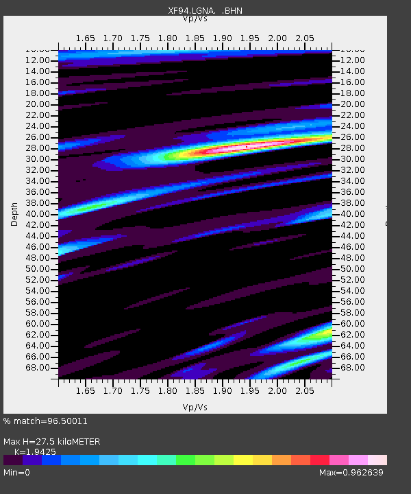
| Estimated Moho Depth: |
27.5 km |
| Estimated Crust Vp/Vs: |
1.94 |
| Assumed Crust Vp: |
6.264 km/s |
| Estimated Crust Vs: |
3.225 km/s |
| Estimated Crust Poisson's Ratio: |
0.32 |
|
| Radial Match: |
96.50011 % |
| Radial Bump: |
400 |
| Transverse Match: |
92.10926 % |
| Transverse Bump: |
400 |
| SOD ConfigId: |
16938 |
| Insert Time: |
2010-03-09 20:47:42.934 +0000 |
| GWidth: |
2.5 |
| Max Bumps: |
400 |
| Tol: |
0.001 |
|

Signal To Noise
| Channel | StoN | STA | LTA |
| XF:LGNA: :BHN:19940609T00:42:29.779028Z | 4.8831706 | 1.3058383E-6 | 2.6741608E-7 |
| XF:LGNA: :BHE:19940609T00:42:29.779028Z | 11.6402855 | 3.117331E-6 | 2.6780538E-7 |
| XF:LGNA: :BHZ:19940609T00:42:29.779028Z | 11.290738 | 8.440656E-6 | 7.4757344E-7 |
| Arrivals |
| Ps | 4.3 SECOND |
| PpPs | 13 SECOND |
| PsPs/PpSs | 17 SECOND |


