
Station XF LGNA - Laguna Mountain Observatory, San Diego Co., Calif.
Network: XF94 - Penninsular Ranges, California
Nearby stations (2 deg radius)
| Station | Name | (Lat, Lon) | Start / End | Elevation |
| LGNA | Laguna Mountain Observatory, San Diego Co., Calif. | (32.84, -116.41) | 1994-03-25 / 1994-11-04 | 5667 m |
| Crust2 Type: | MG,very thin extended crust, 0.5 km seds. |
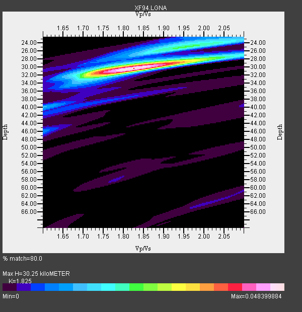
| Thickness Estimate: | 30 km |
| Thickness StdDev: | 0.6 km |
| Vp/Vs Estimate: | 1.83 |
| Vp/Vs StdDev: | 0.04 |
| Vs Estimate: | 3.432 km/s |
| Poisson's Ratio: | 0.29 |
| Peak Value: | 0.05 |
| Assumed Vp: | 6.264 km/s |
| Ps Weight: | 0.33333334 |
| PpPs Weight: | 0.33333334 |
| PsPs Weight: | 0.33333328 |
| Residual Complexity: | 0.386 |
| Nearby stations H: | +- |
| (2.0 deg) Vp/Vs: | +- |
2 with match > 90% ( 7.142857 %) and 5 with match > 80% ( 17.857143 %) out of 28.
Download stack as xyz text file.
Azimuth Distribution of Events:

Prior Results for this Station
| Study | Thickness | Vp/Vs | Vp | Vs | Poissons Ratio | Extra |
| EARS | 30 km | 1.83 | 6.264 km/s | 3.432 km/s | 0.29 | |
| Crust2.0 | 28 km | 1.78 | 6.264 km/s | 3.524 km/s | 0.27 | MG,very thin extended crust, 0.5 km seds. |
| Zhu S. Cal. | 31 km | 1.81 | 6.3 km/s | 3.481 km/s | 0.28 | |
| Global Maxima | 30 km | 1.83 | 6.264 km/s | 3.432 km/s | 0.29 | amp=0.048399884 |
| Local Maxima 1 | 24 km | 2.00 | 6.264 km/s | 3.136 km/s | 0.33 | amp=0.016653134 |
| Local Maxima 2 | 27 km | 2.06 | 6.264 km/s | 3.044 km/s | 0.35 | amp=0.012273744 |
| Local Maxima 3 | 31 km | 1.74 | 6.264 km/s | 3.595 km/s | 0.25 | amp=0.009370925 |
| Local Maxima 4 | 40 km | 1.60 | 6.264 km/s | 3.915 km/s | 0.18 | amp=0.008636633 |
| Predicted Arrivals for vertical incidence (zero ray parameter) | |
| Ps | 3.98 SECOND |
| PpPs | 13.64 SECOND |
| PsPs/PpSs | 17.63 SECOND |
Events Processed for this Station
Download zip of receiver functions as SAC
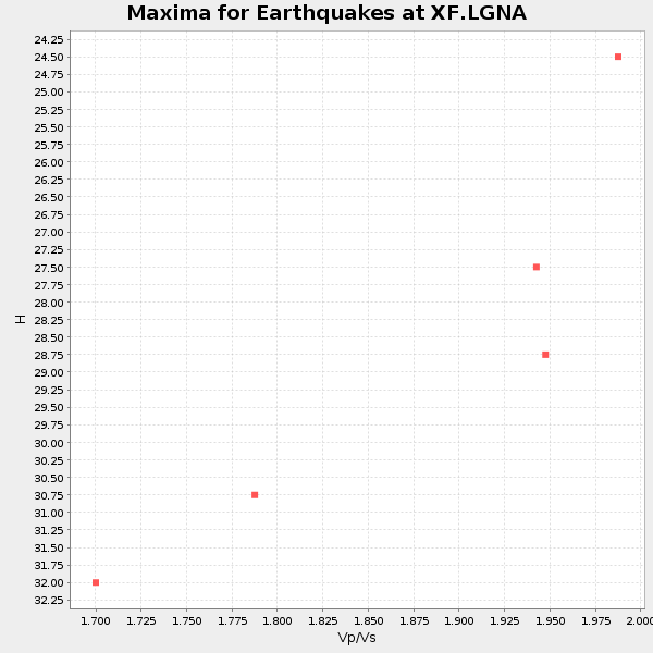
Plot maxima for each earthquake.
Events Used in the Stack
(5 events)| Radial Match | Distance | Baz | FERegion | Time | Lat/Lon | Depth | Magnitude |
| 96.50011 | 65.8 deg | 126.688 deg | Northern Bolivia | 1994/06/09 00:33:16 GMT | (-13.8, -67.6) | 637 km | 6.9 MB, 6.8 MS, 8.3 UNKNOWN, 8.2 MW |
| 93.14169 | 81.9 deg | 315.491 deg | Primor'ye, Russia | 1994/07/21 18:36:31 GMT | (42.3, 132.9) | 473 km | 6.4 MB, 7.2 UNKNOWN |
| 83.97057 | 70.0 deg | 310.742 deg | East Of Kuril Islands | 1994/08/28 18:37:19 GMT | (44.7, 150.2) | 14 km | 6.0 MB, 6.5 MS, 6.3 UNKNOWN, 6.7 MW |
| 81.759026 | 87.7 deg | 248.642 deg | Vanuatu Islands | 1994/07/13 02:35:55 GMT | (-16.6, 167.5) | 33 km | 6.3 MB, 7.4 MS, 7.3 UNKNOWN, 7.1 MW |
| 81.211296 | 79.3 deg | 134.048 deg | Santiago Del Estero Prov., Arg. | 1994/05/10 06:36:28 GMT | (-28.5, -63.1) | 605 km | 6.4 MB, 6.2 UNKNOWN, 6.9 MW |
Losers
(23 events)| Radial Match | Distance | Baz | FERegion | Time | Lat/Lon | Depth | Magnitude | Reason |
| 78.209694 | 87.3 deg | 247.86 deg | Vanuatu Islands | 1994/05/04 06:37:37 GMT | (-17.1, 168.3) | 221 km | 5.7 MB | |
| 75.9154 | 87.7 deg | 248.744 deg | Vanuatu Islands | 1994/07/14 00:09:26 GMT | (-16.5, 167.4) | 33 km | 5.4 MB, 6.0 MS, 5.9 UNKNOWN, 6.1 MW | |
| 73.23052 | 87.9 deg | 247.895 deg | Vanuatu Islands | 1994/04/06 12:13:48 GMT | (-17.4, 167.7) | 44 km | 5.5 MB, 6.0 MS, 6.1 UNKNOWN, 6.2 MW | |
| 72.84793 | 62.2 deg | 316.297 deg | Near East Coast Of Kamchatka | 1994/08/02 14:17:54 GMT | (52.4, 158.1) | 170 km | 5.8 MB, 5.9 UNKNOWN, 5.8 MW | |
| 70.81234 | 77.7 deg | 132.966 deg | Santiago Del Estero Prov., Arg. | 1994/08/19 10:02:51 GMT | (-26.7, -63.4) | 565 km | 6.4 MB, 6.5 UNKNOWN, 6.5 MW | |
| 69.194984 | 77.0 deg | 233.645 deg | Tonga Islands | 1994/08/11 20:42:09 GMT | (-21.5, -173.8) | 33 km | 5.8 MB, 5.5 MS, 5.8 UNKNOWN | |
| 67.93422 | 70.0 deg | 310.708 deg | East Of Kuril Islands | 1994/08/14 00:46:22 GMT | (44.7, 150.1) | 33 km | 5.9 MB, 5.8 MS, 5.4 UNKNOWN, 6.1 MW | |
| 65.96151 | 90.1 deg | 261.022 deg | Solomon Islands | 1994/07/22 16:57:50 GMT | (-7.7, 158.3) | 31 km | 5.7 MB, 6.0 MS, 6.1 UNKNOWN | |
| 63.578873 | 70.6 deg | 311.065 deg | Kuril Islands | 1994/08/20 04:38:51 GMT | (44.7, 149.1) | 33 km | 6.1 MB, 6.0 MS, 5.7 UNKNOWN, 6.3 MW | |
| 60.418594 | 73.1 deg | 311.288 deg | Hokkaido, Japan Region | 1994/08/31 09:07:26 GMT | (43.7, 146.0) | 80 km | 5.9 MB, 6.2 UNKNOWN, 6.2 MW | |
| 57.386467 | 89.7 deg | 307.676 deg | Kyushu, Japan | 1994/04/30 03:28:39 GMT | (31.3, 131.2) | 30 km | 5.6 MB, 5.3 MS, 5.1 UNKNOWN, 5.8 MW | |
| 53.190372 | 45.7 deg | 121.532 deg | South Of Panama | 1994/06/03 11:25:09 GMT | (3.6, -78.8) | 28 km | 5.9 MB, 5.1 MS, 5.1 UNKNOWN, 5.8 MW | |
| 51.435352 | 55.7 deg | 100.491 deg | Trinidad | 1994/05/03 16:36:45 GMT | (10.3, -60.8) | 51 km | 5.7 MB, 5.8 MS, 5.9 UNKNOWN, 6.3 MW | |
| 49.6426 | 64.9 deg | 129.86 deg | Southern Peru | 1994/06/16 18:41:31 GMT | (-15.2, -70.3) | 225 km | 5.6 MB, 5.8 UNKNOWN, 6.1 MW | |
| 49.236916 | 85.6 deg | 240.087 deg | Southeast Of Loyalty Islands | 1994/09/13 12:22:12 GMT | (-22.3, 174.7) | 33 km | 5.5 MB, 5.4 MS | |
| 48.106777 | 72.4 deg | 237.74 deg | Tonga Islands | 1994/04/04 01:37:03 GMT | (-15.5, -173.2) | 33 km | 5.8 MB, 5.5 MS | |
| 44.690144 | 87.7 deg | 248.378 deg | Vanuatu Islands | 1994/07/29 07:53:31 GMT | (-16.8, 167.7) | 33 km | 5.5 MB, 5.8 MS, 6.2 UNKNOWN, 5.9 MW | |
| 41.181473 | 76.9 deg | 233.589 deg | Tonga Islands | 1994/04/27 09:23:27 GMT | (-21.5, -173.7) | 35 km | 6.2 MB, 6.1 MS, 6.0 UNKNOWN, 6.4 MW | |
| 40.74561 | 94.4 deg | 266.336 deg | New Britain Region, P.N.G. | 1994/06/13 21:15:04 GMT | (-5.5, 151.9) | 31 km | 5.8 MB, 6.0 MS, 6.0 UNKNOWN, 6.2 MW | |
| 29.770334 | 86.9 deg | 248.886 deg | Vanuatu Islands | 1994/04/26 23:36:45 GMT | (-16.0, 168.0) | 187 km | 5.6 MB | |
| 24.629305 | 79.2 deg | 235.369 deg | Fiji Islands Region | 1994/08/11 19:32:52 GMT | (-21.7, -176.8) | 180 km | 5.5 MB | |
| 23.966337 | 76.1 deg | 239.974 deg | Fiji Islands Region | 1994/07/05 02:59:42 GMT | (-16.3, -177.5) | 413 km | 5.4 MB, 5.8 UNKNOWN | |
| 17.174128 | 87.8 deg | 248.319 deg | Vanuatu Islands | 1994/07/24 17:55:42 GMT | (-17.0, 167.6) | 33 km | 5.6 MB, 6.5 MS, 6.6 UNKNOWN |
