You are here: Home > Network List > XF94 - Penninsular Ranges, California Stations List
> Station LGNA Laguna Mountain Observatory, San Diego Co., Calif. > Earthquake Result Viewer
LGNA Laguna Mountain Observatory, San Diego Co., Calif. - Earthquake Result Viewer
| Earthquake location: |
East Of Kuril Islands |
| Earthquake latitude/longitude: |
44.7/150.2 |
| Earthquake time(UTC): |
1994/08/28 (240) 18:37:19 GMT |
| Earthquake Depth: |
14 km |
| Earthquake Magnitude: |
6.0 MB, 6.5 MS, 6.3 UNKNOWN, 6.7 MW |
| Earthquake Catalog/Contributor: |
WHDF/NEIC |
|
| Network: |
XF Penninsular Ranges, California |
| Station: |
LGNA Laguna Mountain Observatory, San Diego Co., Calif. |
| Lat/Lon: |
32.84 N/116.41 W |
| Elevation: |
5667 m |
|
| Distance: |
70.0 deg |
| Az: |
63.449 deg |
| Baz: |
310.742 deg |
| Ray Param: |
0.05528985 |
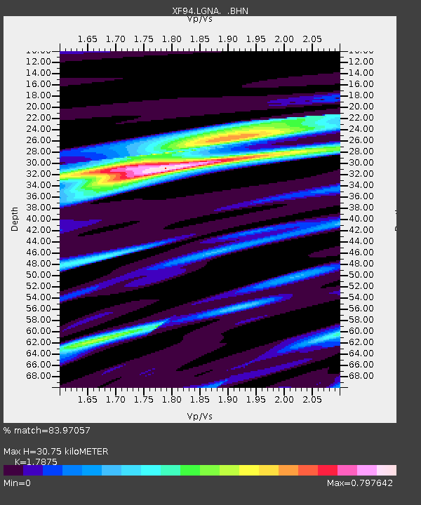
| Estimated Moho Depth: |
30.75 km |
| Estimated Crust Vp/Vs: |
1.79 |
| Assumed Crust Vp: |
6.264 km/s |
| Estimated Crust Vs: |
3.504 km/s |
| Estimated Crust Poisson's Ratio: |
0.27 |
|
| Radial Match: |
83.97057 % |
| Radial Bump: |
400 |
| Transverse Match: |
70.43107 % |
| Transverse Bump: |
400 |
| SOD ConfigId: |
17000 |
| Insert Time: |
2010-03-09 20:47:47.788 +0000 |
| GWidth: |
2.5 |
| Max Bumps: |
400 |
| Tol: |
0.001 |
|

Signal To Noise
| Channel | StoN | STA | LTA |
| XF:LGNA: :BHN:19940828T18:47:59.278003Z | 3.030802 | 4.0133716E-7 | 1.3241946E-7 |
| XF:LGNA: :BHE:19940828T18:47:59.278003Z | 0.55896926 | 1.3572746E-7 | 2.428174E-7 |
| XF:LGNA: :BHZ:19940828T18:47:59.278003Z | 1.4573772 | 1.5950774E-7 | 1.0944849E-7 |
| Arrivals |
| Ps | 4.0 SECOND |
| PpPs | 13 SECOND |
| PsPs/PpSs | 17 SECOND |


