You are here: Home > Network List > XF94 - Penninsular Ranges, California Stations List
> Station PINE Pine Valley, Pine Valley, Calif. > Earthquake Result Viewer
PINE Pine Valley, Pine Valley, Calif. - Earthquake Result Viewer
| Earthquake location: |
Tonga Islands |
| Earthquake latitude/longitude: |
-21.5/-173.7 |
| Earthquake time(UTC): |
1994/04/27 (117) 09:23:27 GMT |
| Earthquake Depth: |
35 km |
| Earthquake Magnitude: |
6.2 MB, 6.1 MS, 6.0 UNKNOWN, 6.4 MW |
| Earthquake Catalog/Contributor: |
WHDF/NEIC |
|
| Network: |
XF Penninsular Ranges, California |
| Station: |
PINE Pine Valley, Pine Valley, Calif. |
| Lat/Lon: |
32.83 N/116.53 W |
| Elevation: |
3515 m |
|
| Distance: |
76.8 deg |
| Az: |
46.618 deg |
| Baz: |
233.516 deg |
| Ray Param: |
0.05071036 |
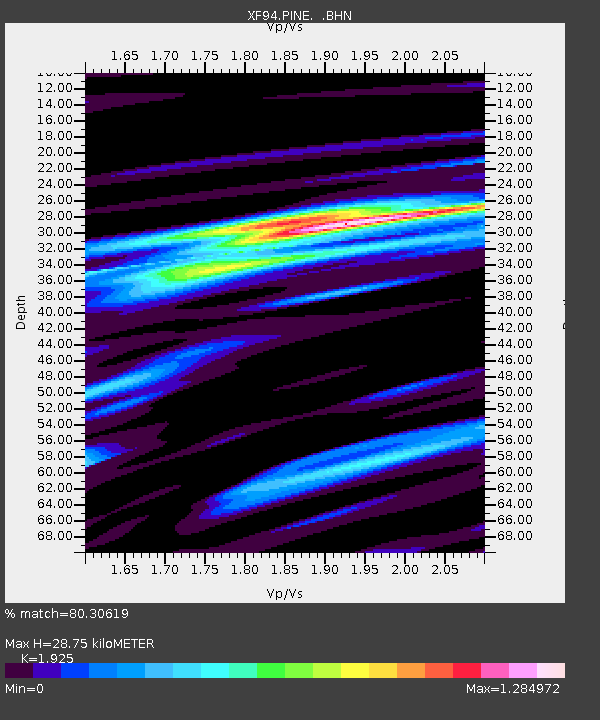
| Estimated Moho Depth: |
28.75 km |
| Estimated Crust Vp/Vs: |
1.92 |
| Assumed Crust Vp: |
6.264 km/s |
| Estimated Crust Vs: |
3.254 km/s |
| Estimated Crust Poisson's Ratio: |
0.32 |
|
| Radial Match: |
80.30619 % |
| Radial Bump: |
400 |
| Transverse Match: |
48.313305 % |
| Transverse Bump: |
400 |
| SOD ConfigId: |
16938 |
| Insert Time: |
2010-03-09 20:48:46.286 +0000 |
| GWidth: |
2.5 |
| Max Bumps: |
400 |
| Tol: |
0.001 |
|

Signal To Noise
| Channel | StoN | STA | LTA |
| XF:PINE: :BHN:19940427T09:34:44.194995Z | 1.083591 | 2.9834484E-7 | 2.7532977E-7 |
| XF:PINE: :BHE:19940427T09:34:44.194995Z | 1.1133288 | 6.3139015E-7 | 5.6711923E-7 |
| XF:PINE: :BHZ:19940427T09:34:44.194995Z | 1.8601998 | 1.181017E-6 | 6.348871E-7 |
| Arrivals |
| Ps | 4.4 SECOND |
| PpPs | 13 SECOND |
| PsPs/PpSs | 17 SECOND |


