
Station XF PINE - Pine Valley, Pine Valley, Calif.
Network: XF94 - Penninsular Ranges, California
Nearby stations (2 deg radius)
| Station | Name | (Lat, Lon) | Start / End | Elevation |
| PINE | Pine Valley, Pine Valley, Calif. | (32.83, -116.53) | 1994-04-14 / 1994-11-04 | 3515 m |
| Crust2 Type: | MG,very thin extended crust, 0.5 km seds. |
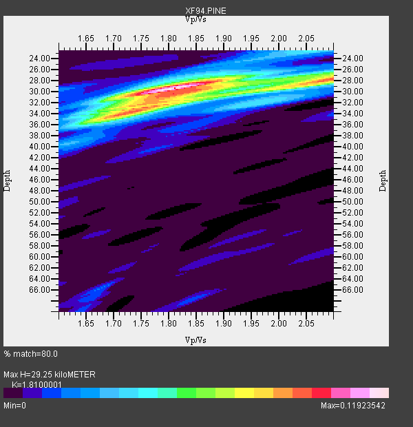
| Thickness Estimate: | 29 km |
| Thickness StdDev: | 1.8 km |
| Vp/Vs Estimate: | 1.81 |
| Vp/Vs StdDev: | 0.12 |
| Vs Estimate: | 3.461 km/s |
| Poisson's Ratio: | 0.28 |
| Peak Value: | 0.12 |
| Assumed Vp: | 6.264 km/s |
| Ps Weight: | 0.33333334 |
| PpPs Weight: | 0.33333334 |
| PsPs Weight: | 0.33333328 |
| Residual Complexity: | 0.625 |
| Nearby stations H: | +- |
| (2.0 deg) Vp/Vs: | +- |
2 with match > 90% ( 9.090909 %) and 5 with match > 80% ( 22.727272 %) out of 22.
Download stack as xyz text file.
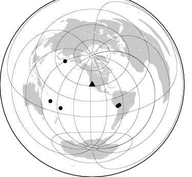
Azimuth Distribution of Events:
Prior Results for this Station
| Study | Thickness | Vp/Vs | Vp | Vs | Poissons Ratio | Extra |
| EARS | 29 km | 1.81 | 6.264 km/s | 3.461 km/s | 0.28 | |
| Crust2.0 | 28 km | 1.78 | 6.264 km/s | 3.524 km/s | 0.27 | MG,very thin extended crust, 0.5 km seds. |
| Zhu S. Cal. | 32 km | 1.85 | 6.3 km/s | 3.405 km/s | 0.29 | |
| Global Maxima | 29 km | 1.81 | 6.264 km/s | 3.461 km/s | 0.28 | amp=0.11923542 |
| Local Maxima 1 | 28 km | 2.09 | 6.264 km/s | 2.993 km/s | 0.35 | amp=0.088072754 |
| Local Maxima 2 | 32 km | 1.77 | 6.264 km/s | 3.529 km/s | 0.27 | amp=0.06669314 |
| Local Maxima 3 | 22 km | 2.05 | 6.264 km/s | 3.055 km/s | 0.34 | amp=0.03741719 |
| Local Maxima 4 | 35 km | 1.68 | 6.264 km/s | 3.723 km/s | 0.23 | amp=0.03638158 |
| Predicted Arrivals for vertical incidence (zero ray parameter) | |
| Ps | 3.78 SECOND |
| PpPs | 13.12 SECOND |
| PsPs/PpSs | 16.90 SECOND |
Events Processed for this Station
Download zip of receiver functions as SAC
Plot maxima for each earthquake.
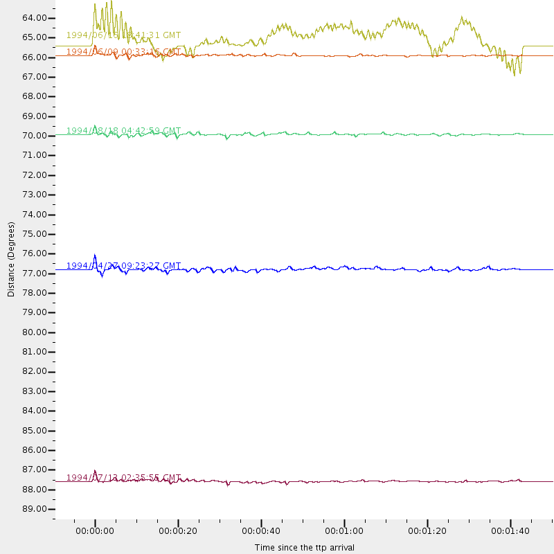
Events Used in the Stack
(5 events)| Radial Match | Distance | Baz | FERegion | Time | Lat/Lon | Depth | Magnitude |
| 94.48858 | 65.9 deg | 126.6 deg | Northern Bolivia | 1994/06/09 00:33:16 GMT | (-13.8, -67.6) | 637 km | 6.9 MB, 6.8 MS, 8.3 UNKNOWN, 8.2 MW |
| 91.87386 | 87.6 deg | 248.581 deg | Vanuatu Islands | 1994/07/13 02:35:55 GMT | (-16.6, 167.5) | 33 km | 6.3 MB, 7.4 MS, 7.3 UNKNOWN, 7.1 MW |
| 88.45205 | 65.0 deg | 129.769 deg | Southern Peru | 1994/06/16 18:41:31 GMT | (-15.2, -70.3) | 225 km | 5.6 MB, 5.8 UNKNOWN, 6.1 MW |
| 83.40419 | 69.9 deg | 310.672 deg | East Of Kuril Islands | 1994/08/18 04:42:59 GMT | (44.7, 150.2) | 33 km | 6.1 MB, 6.5 MS, 6.6 UNKNOWN, 6.5 MW |
| 80.30619 | 76.8 deg | 233.516 deg | Tonga Islands | 1994/04/27 09:23:27 GMT | (-21.5, -173.7) | 35 km | 6.2 MB, 6.1 MS, 6.0 UNKNOWN, 6.4 MW |
Losers
(17 events)| Radial Match | Distance | Baz | FERegion | Time | Lat/Lon | Depth | Magnitude | Reason |
| 87.5812 | 88.5 deg | 186.619 deg | Pacific-Antarctic Ridge | 1994/08/05 19:41:56 GMT | (-55.5, -128.2) | 10 km | 5.5 MS, 5.1 MB | |
| 63.01537 | 87.2 deg | 247.798 deg | Vanuatu Islands | 1994/05/04 06:37:37 GMT | (-17.1, 168.3) | 221 km | 5.7 MB | |
| 62.147217 | 45.7 deg | 121.42 deg | South Of Panama | 1994/06/03 11:25:09 GMT | (3.6, -78.8) | 28 km | 5.9 MB, 5.1 MS, 5.1 UNKNOWN, 5.8 MW | |
| 61.36845 | 87.7 deg | 248.725 deg | Vanuatu Islands | 1994/07/13 02:43:46 GMT | (-16.6, 167.4) | 33 km | 5.6 MB | |
| 60.54779 | 87.7 deg | 248.257 deg | Vanuatu Islands | 1994/07/24 17:55:42 GMT | (-17.0, 167.6) | 33 km | 5.6 MB, 6.5 MS, 6.6 UNKNOWN | |
| 58.880432 | 76.9 deg | 233.573 deg | Tonga Islands | 1994/08/11 20:42:09 GMT | (-21.5, -173.8) | 33 km | 5.8 MB, 5.5 MS, 5.8 UNKNOWN | |
| 53.01307 | 83.8 deg | 230.119 deg | Kermadec Islands Region | 1994/06/20 09:44:46 GMT | (-28.8, -176.9) | 33 km | 5.8 MS, 5.2 MB, 5.9 UNKNOWN | |
| 51.95059 | 55.8 deg | 100.415 deg | Trinidad | 1994/05/03 16:36:45 GMT | (10.3, -60.8) | 51 km | 5.7 MB, 5.8 MS, 5.9 UNKNOWN, 6.3 MW | |
| 46.90023 | 81.8 deg | 315.44 deg | Primor'ye, Russia | 1994/07/21 18:36:31 GMT | (42.3, 132.9) | 473 km | 6.4 MB, 7.2 UNKNOWN | |
| 44.519608 | 79.1 deg | 133.91 deg | Santiago Del Estero Prov., Arg. | 1994/04/29 07:11:30 GMT | (-28.3, -63.2) | 573 km | 6.4 MB, 6.0 UNKNOWN, 6.9 MW | |
| 40.56225 | 79.3 deg | 133.974 deg | Santiago Del Estero Prov., Arg. | 1994/05/10 06:36:28 GMT | (-28.5, -63.1) | 605 km | 6.4 MB, 6.2 UNKNOWN, 6.9 MW | |
| 34.68825 | 48.3 deg | 111.502 deg | Northern Colombia | 1994/05/31 17:41:55 GMT | (7.4, -72.1) | 13 km | 6.3 MB, 5.6 MS, 6.0 UNKNOWN, 6.0 MW | |
| 32.934162 | 62.1 deg | 316.274 deg | Near East Coast Of Kamchatka | 1994/08/02 14:17:54 GMT | (52.4, 158.1) | 170 km | 5.8 MB, 5.9 UNKNOWN, 5.8 MW | |
| 29.709225 | 76.0 deg | 239.903 deg | Fiji Islands Region | 1994/07/05 02:59:42 GMT | (-16.3, -177.5) | 413 km | 5.4 MB, 5.8 UNKNOWN | |
| 27.809544 | 68.7 deg | 132.642 deg | Northern Chile | 1994/05/10 01:49:03 GMT | (-19.7, -69.8) | 53 km | 5.8 MB, 4.9 UNKNOWN, 5.9 MW | |
| 25.481922 | 89.6 deg | 307.616 deg | Kyushu, Japan | 1994/04/30 03:28:39 GMT | (31.3, 131.2) | 30 km | 5.6 MB, 5.3 MS, 5.1 UNKNOWN, 5.8 MW | |
| 21.8164 | 78.3 deg | 307.472 deg | Off East Coast Of Honshu, Japan | 1994/08/16 10:09:34 GMT | (37.8, 142.5) | 34 km | 5.8 MB, 5.2 MS, 5.1 UNKNOWN, 5.8 MW |
