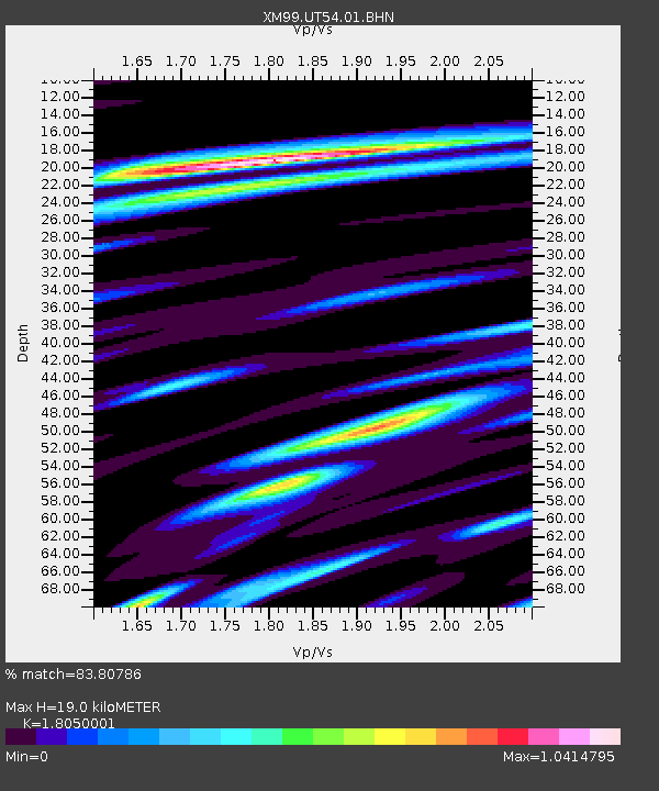
UT54 Utah54 - Earthquake Result Viewer

Earthquake location: Kodiak Island Region, Alaska
Earthquake latitude/longitude: 57.1/-153.2
Earthquake time(UTC): 2001/01/10 (010) 16:02:44 GMT
Earthquake Depth: 33 km
Earthquake Magnitude: 6.2 MB, 6.8 MS, 7.1 MW, 6.8 ML
Earthquake Catalog/Contributor: WHDF/NEIC
Network: XM Rio Grande Seismic Transect
Station: UT54 Utah54
Lat/Lon: 37.42 N/110.51 W
Elevation: 1439 m
Distance: 34.3 deg
Az: 106.478 deg
Baz: 318.876 deg
Ray Param: 0.077768
Estimated Moho Depth: 19.0 km
Estimated Crust Vp/Vs: 1.81
Assumed Crust Vp: 6.247 km/s
Estimated Crust Vs: 3.461 km/s
Estimated Crust Poisson's Ratio: 0.28
Radial Match: 83.80786 %
Radial Bump: 400
Transverse Match: 69.248505 %
Transverse Bump: 400
SOD ConfigId: 16820
Insert Time: 2010-02-26 17:28:04.756 +0000
GWidth: 2.5
Max Bumps: 400
Tol: 0.001

Signal To Noise

ChannelStoNSTALTA
XM:UT54:01:BHN:20010110T16:08:56.900013Z0.556718773.101462E-75.570967E-7
XM:UT54:01:BHE:20010110T16:08:56.900013Z1.5950277.0083354E-74.3938664E-7
XM:UT54:01:BHZ:20010110T16:08:56.900013Z2.4807392.3432237E-69.445668E-7
Arrivals
Ps2.6 SECOND
PpPs7.9 SECOND
PsPs/PpSs11 SECOND