
Station XM UT54 - Utah54
Network: XM99 - Rio Grande Seismic Transect
Nearby stations (2 deg radius)
| Station | Name | (Lat, Lon) | Start / End | Elevation |
| UT54 | Utah54 | (37.42, -110.51) | 1999-11-14 / 2001-12-31 | 1439 m |
| Crust2 Type: | PB,orogen/43km, Orogen, 2 km seds. |
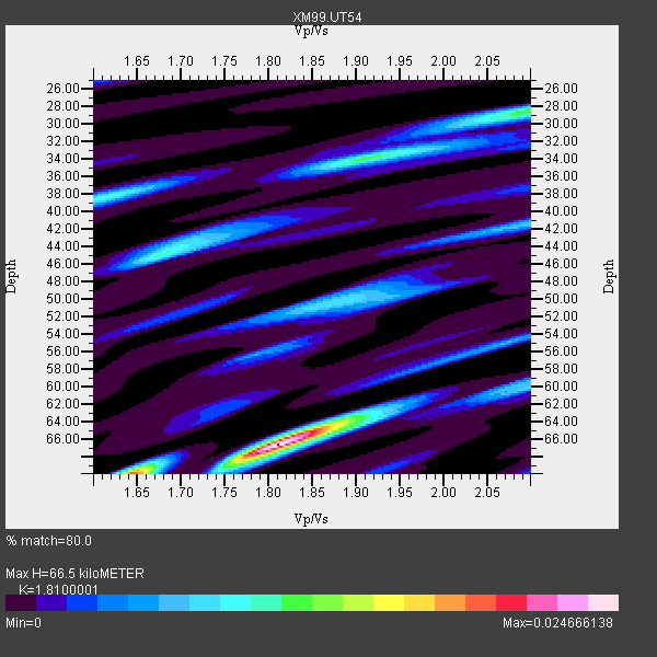
| Thickness Estimate: | 66 km |
| Thickness StdDev: | 11 km |
| Vp/Vs Estimate: | 1.81 |
| Vp/Vs StdDev: | 0.11 |
| Vs Estimate: | 3.451 km/s |
| Poisson's Ratio: | 0.28 |
| Peak Value: | 0.02 |
| Assumed Vp: | 6.247 km/s |
| Ps Weight: | 0.33333334 |
| PpPs Weight: | 0.33333334 |
| PsPs Weight: | 0.33333328 |
| Residual Complexity: | 0.718 |
| Nearby stations H: | +- |
| (2.0 deg) Vp/Vs: | +- |
2 with match > 90% ( 33.333332 %) and 5 with match > 80% ( 83.333336 %) out of 6.
Download stack as xyz text file.
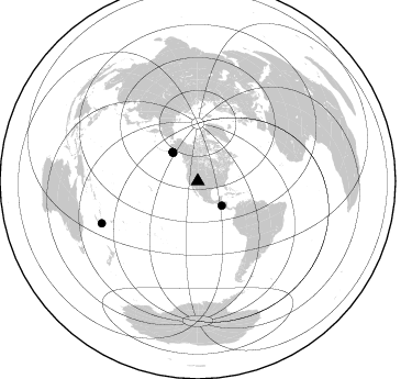
Azimuth Distribution of Events:
Prior Results for this Station
| Study | Thickness | Vp/Vs | Vp | Vs | Poissons Ratio | Extra |
| EARS | 66 km | 1.81 | 6.247 km/s | 3.451 km/s | 0.28 | |
| Crust2.0 | 43 km | 1.76 | 6.247 km/s | 3.544 km/s | 0.26 | PB,orogen/43km, Orogen, 2 km seds. |
| Wilson | 45 km | 1.75 | 6.46 km/s | 3.691 km/s | 0.26 | |
| Global Maxima | 66 km | 1.81 | 6.247 km/s | 3.451 km/s | 0.28 | amp=0.024666138 |
| Local Maxima 1 | 70 km | 1.64 | 6.247 km/s | 3.803 km/s | 0.21 | amp=0.016769532 |
| Local Maxima 2 | 28 km | 2.09 | 6.247 km/s | 2.985 km/s | 0.35 | amp=0.011936481 |
| Local Maxima 3 | 45 km | 1.68 | 6.247 km/s | 3.718 km/s | 0.23 | amp=0.0102531975 |
| Local Maxima 4 | 34 km | 1.90 | 6.247 km/s | 3.283 km/s | 0.31 | amp=0.009254131 |
| Predicted Arrivals for vertical incidence (zero ray parameter) | |
| Ps | 8.62 SECOND |
| PpPs | 29.92 SECOND |
| PsPs/PpSs | 38.54 SECOND |
Events Processed for this Station
Download zip of receiver functions as SAC
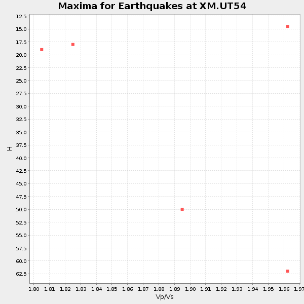
Plot maxima for each earthquake.
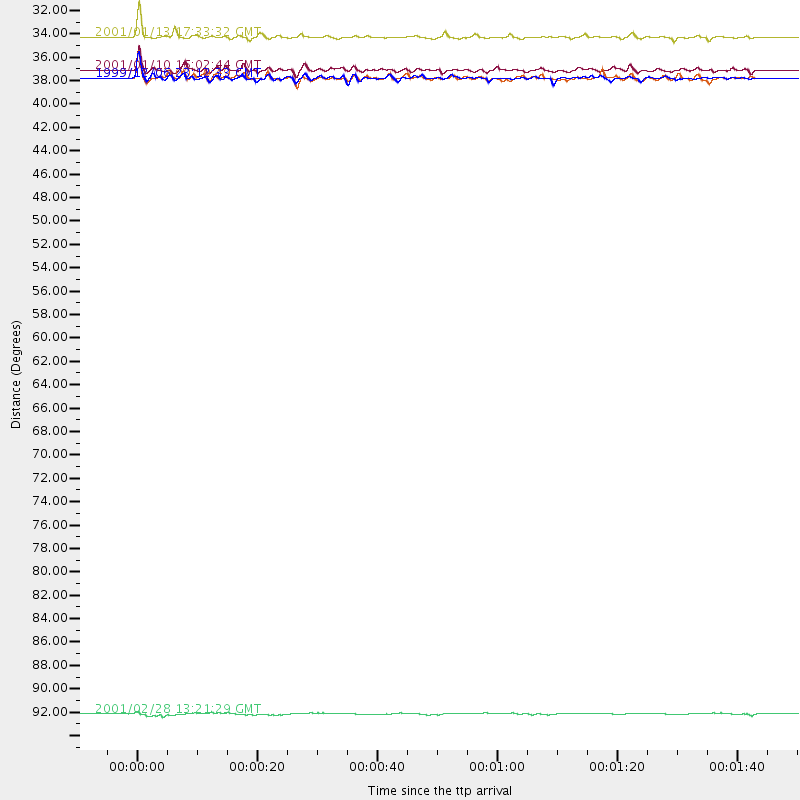
Events Used in the Stack
(5 events)| Radial Match | Distance | Baz | FERegion | Time | Lat/Lon | Depth | Magnitude |
| 93.8754 | 31.1 deg | 135.475 deg | El Salvador | 2001/01/13 17:33:32 GMT | (13.0, -88.7) | 60 km | 6.4 MB, 7.8 MS, 7.7 MW, 7.5 ME |
| 92.0661 | 35.0 deg | 319.106 deg | Kodiak Island Region, Alaska | 1999/12/06 23:12:33 GMT | (57.4, -154.5) | 66 km | 6.8 MB, 7.0 MW, 7.0 ML |
| 86.25275 | 95.3 deg | 246.32 deg | Southeast Of Loyalty Islands | 2001/02/28 13:21:29 GMT | (-22.1, 170.0) | 10 km | 5.6 MB |
| 84.93816 | 35.0 deg | 319.014 deg | Kodiak Island Region, Alaska | 1999/12/07 00:19:49 GMT | (57.4, -154.5) | 41 km | 6.5 MB, 6.1 MS, 6.4 MW, 6.3 ML |
| 83.80786 | 34.3 deg | 318.876 deg | Kodiak Island Region, Alaska | 2001/01/10 16:02:44 GMT | (57.1, -153.2) | 33 km | 6.2 MB, 6.8 MS, 7.1 MW, 6.8 ML |
Losers
(1 events)| Radial Match | Distance | Baz | FERegion | Time | Lat/Lon | Depth | Magnitude | Reason |
| 93.98509 | 95.1 deg | 246.323 deg | Southeast Of Loyalty Islands | 2001/02/28 13:05:31 GMT | (-22.0, 170.1) | 10 km | 5.8 MB, 6.1 MS, 6.2 MW |
