You are here: Home > Network List > XM99 - Rio Grande Seismic Transect Stations List
> Station UT54 Utah54 > Earthquake Result Viewer
UT54 Utah54 - Earthquake Result Viewer
| Earthquake location: |
Southeast Of Loyalty Islands |
| Earthquake latitude/longitude: |
-22.1/170.0 |
| Earthquake time(UTC): |
2001/02/28 (059) 13:21:29 GMT |
| Earthquake Depth: |
10 km |
| Earthquake Magnitude: |
5.6 MB |
| Earthquake Catalog/Contributor: |
WHDF/NEIC |
|
| Network: |
XM Rio Grande Seismic Transect |
| Station: |
UT54 Utah54 |
| Lat/Lon: |
37.42 N/110.51 W |
| Elevation: |
1439 m |
|
| Distance: |
95.3 deg |
| Az: |
51.829 deg |
| Baz: |
246.32 deg |
| Ray Param: |
0.040829267 |
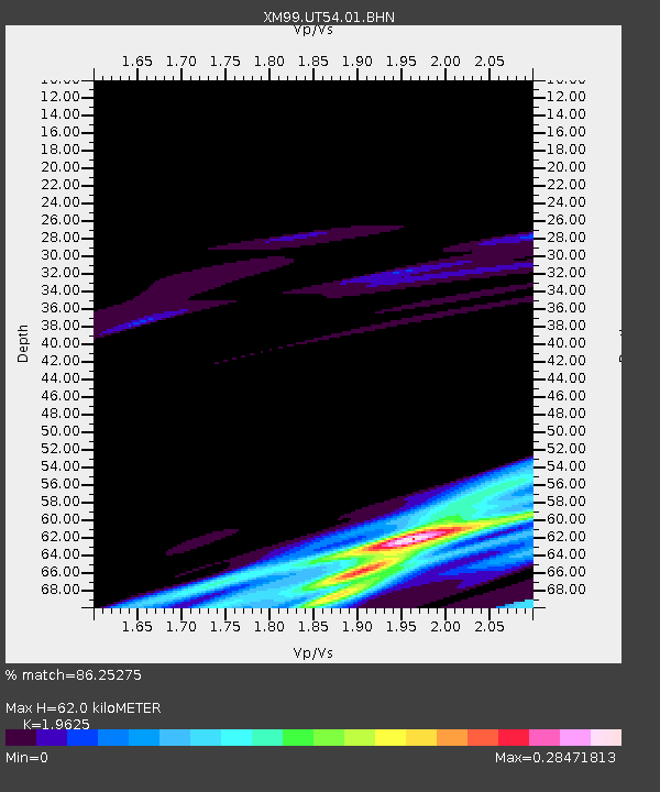
| Estimated Moho Depth: |
62.0 km |
| Estimated Crust Vp/Vs: |
1.96 |
| Assumed Crust Vp: |
6.247 km/s |
| Estimated Crust Vs: |
3.183 km/s |
| Estimated Crust Poisson's Ratio: |
0.32 |
|
| Radial Match: |
86.25275 % |
| Radial Bump: |
249 |
| Transverse Match: |
87.387665 % |
| Transverse Bump: |
258 |
| SOD ConfigId: |
3753 |
| Insert Time: |
2010-02-26 17:28:06.263 +0000 |
| GWidth: |
2.5 |
| Max Bumps: |
400 |
| Tol: |
0.001 |
|
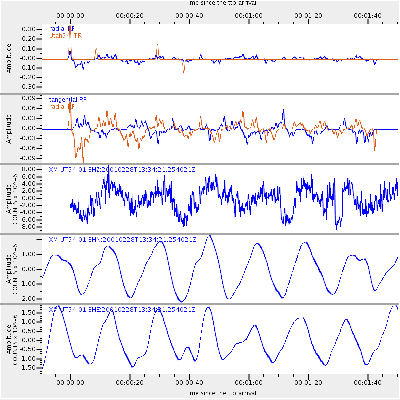
Signal To Noise
| Channel | StoN | STA | LTA |
| XM:UT54:01:BHN:20010228T13:34:21.254021Z | 1.5533514 | 1.0405624E-6 | 6.698822E-7 |
| XM:UT54:01:BHE:20010228T13:34:21.254021Z | 0.55242795 | 5.904723E-7 | 1.0688675E-6 |
| XM:UT54:01:BHZ:20010228T13:34:21.254021Z | 1.012699 | 3.0779213E-6 | 3.039325E-6 |
| Arrivals |
| Ps | 9.7 SECOND |
| PpPs | 29 SECOND |
| PsPs/PpSs | 39 SECOND |


