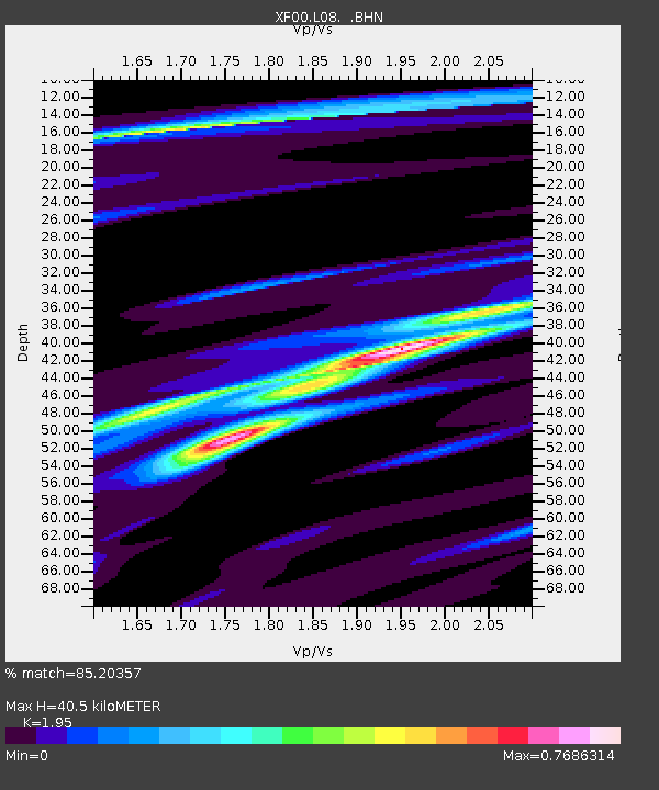
L08 XF.L08 - Earthquake Result Viewer

Earthquake location: Near Coast Of Ecuador
Earthquake latitude/longitude: -0.2/-80.6
Earthquake time(UTC): 2000/09/28 (272) 23:23:43 GMT
Earthquake Depth: 23 km
Earthquake Magnitude: 5.8 MB, 6.0 MS, 6.6 MW, 6.4 MW
Earthquake Catalog/Contributor: WHDF/NEIC
Network: XF Laramie Telemetered Brad-band Array
Station: L08 XF.L08
Lat/Lon: 41.14 N/105.64 W
Elevation: 7410 m
Distance: 47.0 deg
Az: 334.069 deg
Baz: 144.622 deg
Ray Param: 0.07023219
Estimated Moho Depth: 40.5 km
Estimated Crust Vp/Vs: 1.95
Assumed Crust Vp: 6.306 km/s
Estimated Crust Vs: 3.234 km/s
Estimated Crust Poisson's Ratio: 0.32
Radial Match: 85.20357 %
Radial Bump: 285
Transverse Match: 71.45346 %
Transverse Bump: 400
SOD ConfigId: 3744
Insert Time: 2010-03-09 20:53:02.953 +0000
GWidth: 2.5
Max Bumps: 400
Tol: 0.001

Signal To Noise

ChannelStoNSTALTA
XF:L08: :BHN:20000928T23:31:42.024011Z1.41076799.658284E-86.846118E-8
XF:L08: :BHE:20000928T23:31:42.024011Z0.622175342.980678E-84.7907363E-8
XF:L08: :BHZ:20000928T23:31:42.024011Z1.5745141.852579E-71.1766037E-7
Arrivals
Ps6.4 SECOND
PpPs18 SECOND
PsPs/PpSs24 SECOND