
Station XF L08 - XF.L08
Network: XF00 - Laramie Telemetered Brad-band Array
Nearby stations (2 deg radius)
| Station | Name | (Lat, Lon) | Start / End | Elevation |
| L08 | XF.L08 | (41.14, -105.64) | 2000-09-01 / 2002-01-01 | 7410 m |
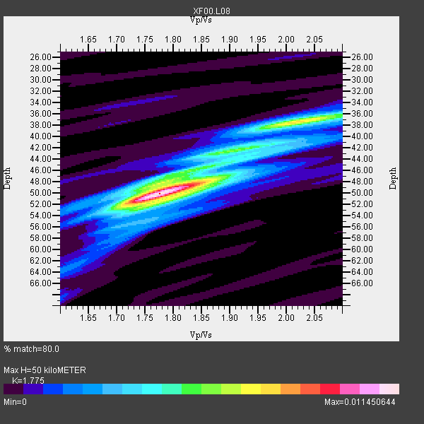
| Crust2 Type: | P4,orogen/50km, Urals, Tethian Orogen, Rockies 1 km seds. |
| Thickness Estimate: | 50 km |
| Thickness StdDev: | 4.2 km |
| Vp/Vs Estimate: | 1.77 |
| Vp/Vs StdDev: | 0.09 |
| Vs Estimate: | 3.553 km/s |
| Poisson's Ratio: | 0.27 |
| Peak Value: | 0.01 |
| Assumed Vp: | 6.306 km/s |
| Ps Weight: | 0.33333334 |
| PpPs Weight: | 0.33333334 |
| PsPs Weight: | 0.33333328 |
| Residual Complexity: | 0.584 |
| Nearby stations H: | +- |
| (2.0 deg) Vp/Vs: | +- |
5 with match > 90% ( 41.666668 %) and 12 with match > 80% ( 100.0 %) out of 12.
Download stack as xyz text file.
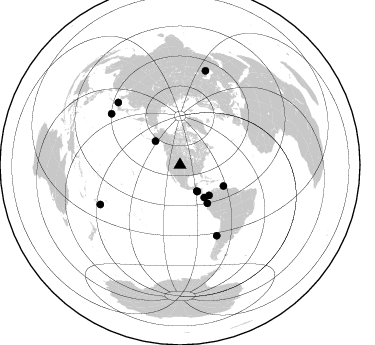
Azimuth Distribution of Events:
Prior Results for this Station
| Study | Thickness | Vp/Vs | Vp | Vs | Poissons Ratio | Extra |
| EARS | 50 km | 1.77 | 6.306 km/s | 3.553 km/s | 0.27 | |
| Crust2.0 | 50 km | 1.76 | 6.306 km/s | 3.584 km/s | 0.26 | P4,orogen/50km, Urals, Tethian Orogen, Rockies 1 km seds. |
| Global Maxima | 50 km | 1.77 | 6.306 km/s | 3.553 km/s | 0.27 | amp=0.011450644 |
| Local Maxima 1 | 38 km | 2.01 | 6.306 km/s | 3.137 km/s | 0.34 | amp=0.0073745036 |
| Local Maxima 2 | 51 km | 1.80 | 6.306 km/s | 3.498 km/s | 0.28 | amp=0.004357573 |
| Local Maxima 3 | 49 km | 1.75 | 6.306 km/s | 3.593 km/s | 0.26 | amp=0.0038206778 |
| Local Maxima 4 | 42 km | 1.99 | 6.306 km/s | 3.169 km/s | 0.33 | amp=0.0030020645 |
| Predicted Arrivals for vertical incidence (zero ray parameter) | |
| Ps | 6.14 SECOND |
| PpPs | 22.00 SECOND |
| PsPs/PpSs | 28.15 SECOND |
Events Processed for this Station
Download zip of receiver functions as SAC
Plot maxima for each earthquake.
Events Used in the Stack
(12 events)| Radial Match | Distance | Baz | FERegion | Time | Lat/Lon | Depth | Magnitude |
| 100.0 | 88.7 deg | 243.7 deg | Fiji Islands Region | 2001/01/11 19:59:39 GMT | (-18.8, -176.7) | 10 km | 5.4 MB, 5.4 MS, 5.8 MW, 5.7 MW |
| 96.04522 | 31.7 deg | 147.184 deg | El Salvador | 2001/01/13 17:33:32 GMT | (13.0, -88.7) | 60 km | 6.4 MB, 7.8 MS, 7.7 MW, 7.5 ME |
| 92.89093 | 79.3 deg | 152.512 deg | Off Coast Of Central Chile | 2001/04/09 09:00:57 GMT | (-32.7, -73.1) | 11 km | 6.1 MB, 6.3 MS, 6.7 MW, 6.3 ME |
| 90.34276 | 40.5 deg | 143.352 deg | South Of Panama | 2000/12/12 05:26:45 GMT | (6.0, -82.7) | 10 km | 5.8 MB, 5.7 MS, 6.3 ME, 6.1 MW |
| 90.21071 | 42.0 deg | 136.226 deg | Panama-Colombia Border Region | 2000/11/08 06:59:58 GMT | (7.0, -77.8) | 17 km | 6.0 MB, 6.4 MS, 6.5 MW, 6.2 ML |
| 88.791855 | 85.7 deg | 306.633 deg | Southeast Of Honshu, Japan | 2001/04/14 23:27:26 GMT | (30.1, 141.8) | 10 km | 6.0 MB, 5.8 MS, 6.0 MW, 6.0 ME |
| 88.10449 | 97.7 deg | 15.138 deg | Turkmenistan | 2000/12/06 17:11:06 GMT | (39.6, 54.8) | 30 km | 6.7 MB, 7.5 MS, 7.0 MW, 6.9 ME |
| 85.20357 | 47.0 deg | 144.622 deg | Near Coast Of Ecuador | 2000/09/28 23:23:43 GMT | (-0.2, -80.6) | 23 km | 5.8 MB, 6.0 MS, 6.6 MW, 6.4 MW |
| 84.390976 | 31.0 deg | 147.156 deg | El Salvador | 2001/02/13 14:22:05 GMT | (13.7, -88.9) | 10 km | 5.5 MB, 6.5 MS, 6.6 MW, 6.1 MD |
| 83.40404 | 34.2 deg | 314.15 deg | Kodiak Island Region, Alaska | 2001/01/10 16:02:44 GMT | (57.1, -153.2) | 33 km | 6.2 MB, 6.8 MS, 7.1 MW, 6.8 ML |
| 81.419205 | 48.2 deg | 115.865 deg | Windward Islands | 2000/10/04 14:37:44 GMT | (11.1, -62.6) | 110 km | 5.6 MB, 5.4 MS, 6.1 MW, 5.9 MD |
| 80.64658 | 88.0 deg | 315.124 deg | Western Honshu, Japan | 2001/03/24 06:27:53 GMT | (34.1, 132.5) | 50 km | 6.4 MB, 6.5 MS, 6.8 MW, 6.4 ME |
Losers
(0 events)| Radial Match | Distance | Baz | FERegion | Time | Lat/Lon | Depth | Magnitude | Reason |
