You are here: Home > Network List > XM99 - Rio Grande Seismic Transect Stations List
> Station UT52 Utah52 > Earthquake Result Viewer
UT52 Utah52 - Earthquake Result Viewer
| Earthquake location: |
Vanuatu Islands Region |
| Earthquake latitude/longitude: |
-19.5/173.8 |
| Earthquake time(UTC): |
2000/02/25 (056) 01:43:58 GMT |
| Earthquake Depth: |
33 km |
| Earthquake Magnitude: |
6.1 MB, 7.1 MS, 7.1 MW, 7.0 MW |
| Earthquake Catalog/Contributor: |
WHDF/NEIC |
|
| Network: |
XM Rio Grande Seismic Transect |
| Station: |
UT52 Utah52 |
| Lat/Lon: |
37.23 N/110.13 W |
| Elevation: |
1671 m |
|
| Distance: |
91.1 deg |
| Az: |
50.779 deg |
| Baz: |
246.281 deg |
| Ray Param: |
0.041624084 |
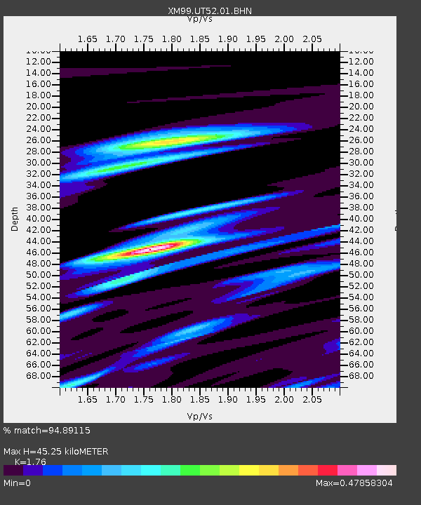
| Estimated Moho Depth: |
45.25 km |
| Estimated Crust Vp/Vs: |
1.76 |
| Assumed Crust Vp: |
6.247 km/s |
| Estimated Crust Vs: |
3.549 km/s |
| Estimated Crust Poisson's Ratio: |
0.26 |
|
| Radial Match: |
94.89115 % |
| Radial Bump: |
329 |
| Transverse Match: |
74.20922 % |
| Transverse Bump: |
400 |
| SOD ConfigId: |
3744 |
| Insert Time: |
2010-02-26 17:28:12.264 +0000 |
| GWidth: |
2.5 |
| Max Bumps: |
400 |
| Tol: |
0.001 |
|

Signal To Noise
| Channel | StoN | STA | LTA |
| XM:UT52:01:BHN:20000225T01:56:28.470994Z | 0.65270275 | 1.3386963E-7 | 2.0510046E-7 |
| XM:UT52:01:BHE:20000225T01:56:28.470994Z | 1.29936 | 1.1360338E-7 | 8.743025E-8 |
| XM:UT52:01:BHZ:20000225T01:56:28.470994Z | 1.821566 | 3.5055308E-7 | 1.92446E-7 |
| Arrivals |
| Ps | 5.6 SECOND |
| PpPs | 20 SECOND |
| PsPs/PpSs | 25 SECOND |


