
Station XM UT52 - Utah52
Network: XM99 - Rio Grande Seismic Transect
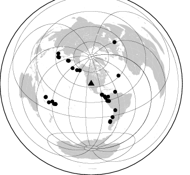
Nearby stations (2 deg radius)
| Station | Name | (Lat, Lon) | Start / End | Elevation |
| UT52 | Utah52 | (37.23, -110.13) | 1999-07-29 / 2001-12-31 | 1671 m |
| Crust2 Type: | PB,orogen/43km, Orogen, 2 km seds. |
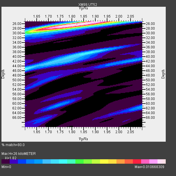
| Thickness Estimate: | 26 km |
| Thickness StdDev: | 3.9 km |
| Vp/Vs Estimate: | 1.82 |
| Vp/Vs StdDev: | 0.08 |
| Vs Estimate: | 3.432 km/s |
| Poisson's Ratio: | 0.28 |
| Peak Value: | 0.01 |
| Assumed Vp: | 6.247 km/s |
| Ps Weight: | 0.33333334 |
| PpPs Weight: | 0.33333334 |
| PsPs Weight: | 0.33333328 |
| Residual Complexity: | 0.559 |
| Nearby stations H: | +- |
| (2.0 deg) Vp/Vs: | +- |
10 with match > 90% ( 30.30303 %) and 29 with match > 80% ( 87.878784 %) out of 33.
Download stack as xyz text file.
Azimuth Distribution of Events:
Prior Results for this Station
| Study | Thickness | Vp/Vs | Vp | Vs | Poissons Ratio | Extra |
| EARS | 26 km | 1.82 | 6.247 km/s | 3.432 km/s | 0.28 | |
| Crust2.0 | 43 km | 1.76 | 6.247 km/s | 3.544 km/s | 0.26 | PB,orogen/43km, Orogen, 2 km seds. |
| Wilson | 45 km | 1.75 | 6.46 km/s | 3.691 km/s | 0.26 | |
| Global Maxima | 26 km | 1.82 | 6.247 km/s | 3.432 km/s | 0.28 | amp=0.010668309 |
| Local Maxima 1 | 29 km | 1.65 | 6.247 km/s | 3.792 km/s | 0.21 | amp=0.0052232808 |
| Local Maxima 2 | 45 km | 1.60 | 6.247 km/s | 3.904 km/s | 0.18 | amp=0.0041309525 |
| Local Maxima 3 | 38 km | 1.86 | 6.247 km/s | 3.358 km/s | 0.30 | amp=0.0038773264 |
| Local Maxima 4 | 25 km | 1.99 | 6.247 km/s | 3.143 km/s | 0.33 | amp=0.0031883053 |
| Predicted Arrivals for vertical incidence (zero ray parameter) | |
| Ps | 3.41 SECOND |
| PpPs | 11.74 SECOND |
| PsPs/PpSs | 15.15 SECOND |
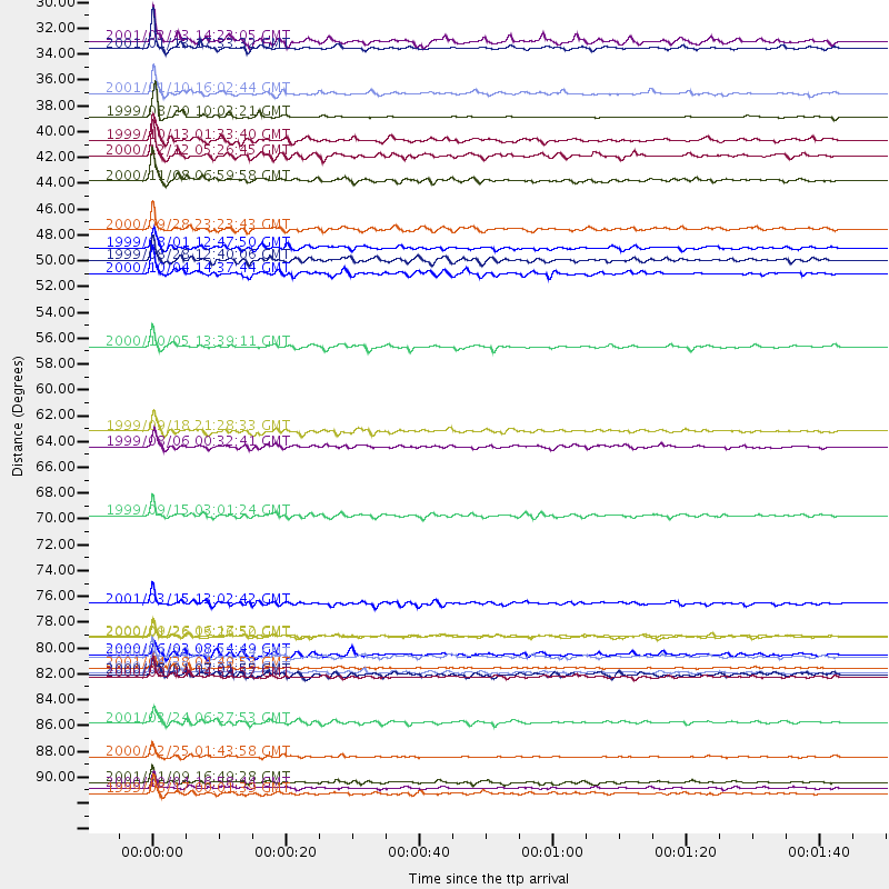
Events Processed for this Station
Download zip of receiver functions as SAC
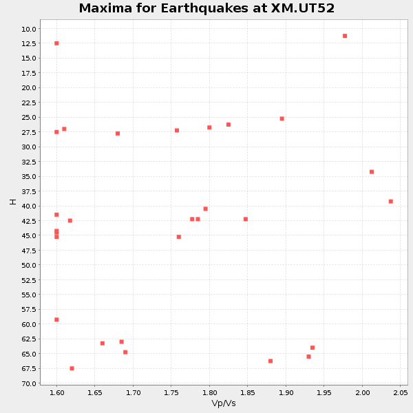
Plot maxima for each earthquake.
Events Used in the Stack
(29 events)| Radial Match | Distance | Baz | FERegion | Time | Lat/Lon | Depth | Magnitude |
| 97.68729 | 80.8 deg | 240.331 deg | Tonga Islands | 2000/09/26 06:17:52 GMT | (-17.2, -173.9) | 56 km | 6.1 MB, 6.1 MS, 6.4 MW, 6.1 ME |
| 97.67186 | 30.8 deg | 135.842 deg | El Salvador | 2001/01/13 17:33:32 GMT | (13.0, -88.7) | 60 km | 6.4 MB, 7.8 MS, 7.7 MW, 7.5 ME |
| 96.46533 | 36.6 deg | 133.492 deg | Costa Rica | 1999/08/20 10:02:21 GMT | (9.0, -84.2) | 20 km | 6.1 MB, 6.9 MS, 7.0 MW, 6.1 ML |
| 95.02773 | 93.7 deg | 253.577 deg | Vanuatu Islands | 2000/10/04 16:58:44 GMT | (-15.4, 166.9) | 23 km | 6.1 MB, 6.9 MS, 6.8 MW, 6.5 ME |
| 94.89115 | 91.1 deg | 246.281 deg | Vanuatu Islands Region | 2000/02/25 01:43:58 GMT | (-19.5, 173.8) | 33 km | 6.1 MB, 7.1 MS, 7.1 MW, 7.0 MW |
| 94.78371 | 83.9 deg | 153.645 deg | Off Coast Of Southern Chile | 1999/08/22 09:35:39 GMT | (-40.5, -74.8) | 33 km | 6.2 MB, 5.8 MS, 6.4 MW, 6.2 MW |
| 94.64118 | 49.9 deg | 108.753 deg | Windward Islands | 2000/10/04 14:37:44 GMT | (11.1, -62.6) | 110 km | 5.6 MB, 5.4 MS, 6.1 MW, 5.9 MD |
| 94.43583 | 94.2 deg | 29.321 deg | Turkey | 1999/08/17 00:01:39 GMT | (40.7, 29.9) | 17 km | 6.3 MB, 7.8 MS, 7.7 ME, 7.6 MW |
| 92.03491 | 34.6 deg | 318.95 deg | Kodiak Island Region, Alaska | 2001/01/10 16:02:44 GMT | (57.1, -153.2) | 33 km | 6.2 MB, 6.8 MS, 7.1 MW, 6.8 ML |
| 90.56629 | 42.0 deg | 127.586 deg | Panama-Colombia Border Region | 2000/11/08 06:59:58 GMT | (7.0, -77.8) | 17 km | 6.0 MB, 6.4 MS, 6.5 MW, 6.2 ML |
| 89.73236 | 30.1 deg | 135.581 deg | El Salvador | 2001/02/13 14:22:05 GMT | (13.7, -88.9) | 10 km | 5.5 MB, 6.5 MS, 6.6 MW, 6.1 MD |
| 89.69902 | 63.4 deg | 315.325 deg | Near East Coast Of Kamchatka | 1999/09/18 21:28:33 GMT | (51.2, 157.6) | 60 km | 5.9 MB, 5.6 MS, 6.2 MW, 6.0 MW |
| 89.55342 | 46.2 deg | 136.905 deg | Near Coast Of Ecuador | 2000/09/28 23:23:43 GMT | (-0.2, -80.6) | 23 km | 5.8 MB, 6.0 MS, 6.6 MW, 6.4 MW |
| 88.70194 | 83.5 deg | 241.655 deg | Fiji Islands Region | 2001/04/28 04:49:53 GMT | (-18.1, -176.9) | 352 km | 6.2 MB, 6.8 MW, 6.8 MW |
| 88.59595 | 82.6 deg | 152.878 deg | Off Coast Of Central Chile | 2000/12/20 11:23:54 GMT | (-39.0, -74.7) | 11 km | 6.1 MB, 6.2 MS, 6.4 MW, 6.0 ME |
| 88.543304 | 47.8 deg | 309.491 deg | Andreanof Islands, Aleutian Is. | 1999/08/01 12:47:50 GMT | (51.5, -176.3) | 33 km | 5.5 MB, 5.5 MS, 5.8 MW, 5.8 MW |
| 88.49928 | 88.2 deg | 312.471 deg | Western Honshu, Japan | 2001/03/24 06:27:53 GMT | (34.1, 132.5) | 50 km | 6.4 MB, 6.5 MS, 6.8 MW, 6.4 ME |
| 87.33201 | 80.9 deg | 240.312 deg | Tonga Islands | 2000/01/26 13:26:50 GMT | (-17.3, -174.0) | 33 km | 5.9 MB, 6.0 MS, 6.4 MW, 6.3 MW |
| 87.12681 | 84.3 deg | 245.478 deg | Fiji Islands | 2000/09/14 14:59:57 GMT | (-15.7, 179.8) | 33 km | 5.7 MB, 6.2 MS, 6.3 MW, 6.2 MW |
| 86.47029 | 38.6 deg | 313.543 deg | Alaska Peninsula | 1999/10/13 01:33:40 GMT | (54.7, -161.2) | 30 km | 6.0 MB, 6.2 MS, 6.5 MW, 6.0 ML |
| 86.20084 | 70.6 deg | 137.603 deg | Southern Bolivia | 1999/09/15 03:01:24 GMT | (-20.9, -67.3) | 218 km | 6.0 MB, 6.4 MW, 6.4 MW |
| 85.38159 | 39.9 deg | 134.379 deg | South Of Panama | 2000/12/12 05:26:45 GMT | (6.0, -82.7) | 10 km | 5.8 MB, 5.7 MS, 6.3 ME, 6.1 MW |
| 85.37068 | 78.0 deg | 147.288 deg | Near Coast Of Central Chile | 2001/03/15 13:02:42 GMT | (-32.3, -71.5) | 37 km | 6.1 MB, 5.6 MS, 6.0 MW, 5.4 MD |
| 84.659164 | 56.1 deg | 73.547 deg | Northern Mid-Atlantic Ridge | 2000/10/05 13:39:11 GMT | (31.7, -41.0) | 10 km | 5.4 MB, 6.1 MS, 6.0 MW, 5.9 MW |
| 84.505424 | 48.8 deg | 134.299 deg | Ecuador | 1999/08/28 12:40:06 GMT | (-1.3, -77.5) | 196 km | 5.9 MB, 6.3 MW, 6.2 MW |
| 84.353226 | 84.1 deg | 308.822 deg | Near S. Coast Of Honshu, Japan | 2000/07/01 07:01:55 GMT | (34.2, 139.1) | 10 km | 6.0 MB, 6.1 MS, 6.2 MW, 6.2 MW |
| 82.13221 | 64.7 deg | 314.492 deg | Kuril Islands | 1999/08/06 00:32:41 GMT | (49.9, 156.3) | 58 km | 5.5 MB, 5.5 MS, 5.9 MW, 5.8 MW |
| 81.734344 | 93.2 deg | 253.813 deg | Vanuatu Islands | 2001/01/09 16:49:28 GMT | (-14.9, 167.2) | 103 km | 6.3 MB, 6.6 MS, 7.6 ME, 7.0 MW |
| 80.01893 | 82.4 deg | 309.108 deg | Near East Coast Of Honshu, Japan | 2000/06/03 08:54:49 GMT | (35.6, 140.5) | 62 km | 5.6 MB, 5.6 MS, 6.1 MW, 6.1 MW |
Losers
(4 events)| Radial Match | Distance | Baz | FERegion | Time | Lat/Lon | Depth | Magnitude | Reason |
| 94.2372 | 95.3 deg | 246.522 deg | Southeast Of Loyalty Islands | 2001/02/28 13:05:31 GMT | (-22.0, 170.1) | 10 km | 5.8 MB, 6.1 MS, 6.2 MW | |
| 91.74469 | 95.5 deg | 246.519 deg | Southeast Of Loyalty Islands | 2001/02/28 13:21:29 GMT | (-22.1, 170.0) | 10 km | 5.6 MB | |
| 88.42828 | 93.1 deg | 252.728 deg | Vanuatu Islands | 2000/08/09 00:08:41 GMT | (-15.7, 168.0) | 33 km | 6.3 MB, 6.0 MS, 6.4 MW, 6.3 MW | |
| 80.17029 | 98.2 deg | 270.454 deg | New Ireland Region, P.N.G. | 2000/11/23 18:43:15 GMT | (-4.6, 153.1) | 33 km | 5.7 MB, 6.4 MS, 6.4 MW, 6.3 MW |
