You are here: Home > Network List > XM99 - Rio Grande Seismic Transect Stations List
> Station UT52 Utah52 > Earthquake Result Viewer
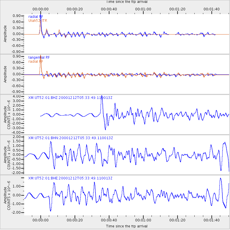
UT52 Utah52 - Earthquake Result Viewer

| Earthquake location: |
South Of Panama |
| Earthquake latitude/longitude: |
6.0/-82.7 |
| Earthquake time(UTC): |
2000/12/12 (347) 05:26:45 GMT |
| Earthquake Depth: |
10 km |
| Earthquake Magnitude: |
5.8 MB, 5.7 MS, 6.3 ME, 6.1 MW |
| Earthquake Catalog/Contributor: |
WHDF/NEIC |
|
| Network: |
XM Rio Grande Seismic Transect |
| Station: |
UT52 Utah52 |
| Lat/Lon: |
37.23 N/110.13 W |
| Elevation: |
1671 m |
|
| Distance: |
39.9 deg |
| Az: |
325.002 deg |
| Baz: |
134.379 deg |
| Ray Param: |
0.07470921 |
| Estimated Moho Depth: |
26.25 km |
| Estimated Crust Vp/Vs: |
1.83 |
| Assumed Crust Vp: |
6.247 km/s |
| Estimated Crust Vs: |
3.423 km/s |
| Estimated Crust Poisson's Ratio: |
0.29 |
|
| Radial Match: |
85.38159 % |
| Radial Bump: |
342 |
| Transverse Match: |
56.350372 % |
| Transverse Bump: |
400 |
| SOD ConfigId: |
27569 |
| Insert Time: |
2010-02-26 17:28:14.714 +0000 |
| GWidth: |
2.5 |
| Max Bumps: |
400 |
| Tol: |
0.001 |
|
Signal To Noise
| Channel | StoN | STA | LTA |
| XM:UT52:01:BHN:20001212T05:33:49.110013Z | 1.3024229 | 2.3957907E-7 | 1.8394874E-7 |
| XM:UT52:01:BHE:20001212T05:33:49.110013Z | 1.1856806 | 1.8232186E-7 | 1.5376978E-7 |
| XM:UT52:01:BHZ:20001212T05:33:49.110013Z | 1.3981272 | 2.7859787E-7 | 1.9926505E-7 |
| Arrivals |
| Ps | 3.7 SECOND |
| PpPs | 11 SECOND |
| PsPs/PpSs | 15 SECOND |


