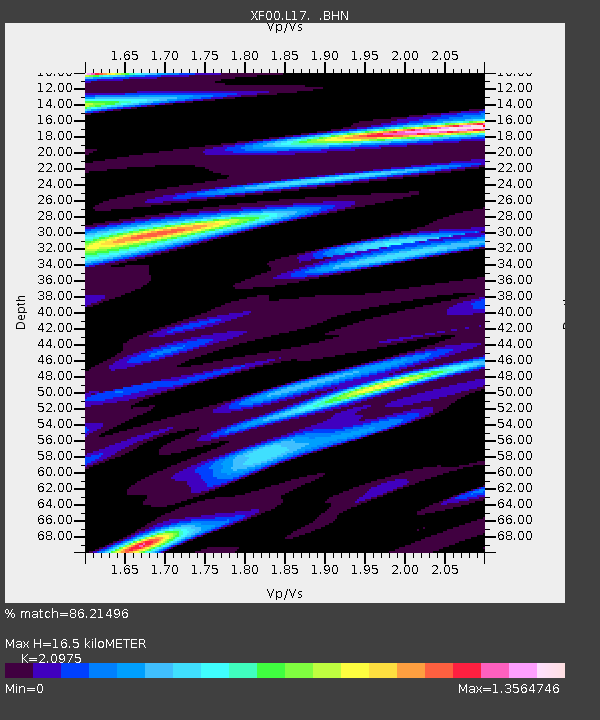
L17 XF.L17 - Earthquake Result Viewer

Earthquake location: South Of Panama
Earthquake latitude/longitude: 6.0/-82.7
Earthquake time(UTC): 2000/12/12 (347) 05:26:45 GMT
Earthquake Depth: 10 km
Earthquake Magnitude: 5.8 MB, 5.7 MS, 6.3 ME, 6.1 MW
Earthquake Catalog/Contributor: WHDF/NEIC
Network: XF Laramie Telemetered Brad-band Array
Station: L17 XF.L17
Lat/Lon: 41.32 N/105.79 W
Elevation: 7450 m
Distance: 40.8 deg
Az: 333.071 deg
Baz: 143.273 deg
Ray Param: 0.074212484
Estimated Moho Depth: 16.5 km
Estimated Crust Vp/Vs: 2.10
Assumed Crust Vp: 6.306 km/s
Estimated Crust Vs: 3.006 km/s
Estimated Crust Poisson's Ratio: 0.35
Radial Match: 86.21496 %
Radial Bump: 400
Transverse Match: 71.67665 %
Transverse Bump: 400
SOD ConfigId: 3744
Insert Time: 2010-03-09 20:55:32.779 +0000
GWidth: 2.5
Max Bumps: 400
Tol: 0.001

Signal To Noise

ChannelStoNSTALTA
XF:L17: :BHN:20001212T05:33:56.174009Z1.18769962.2627115E-71.9051211E-7
XF:L17: :BHE:20001212T05:33:56.174009Z0.58074049.216896E-81.5870941E-7
XF:L17: :BHZ:20001212T05:33:56.174009Z0.590295737.019606E-81.1891677E-7
Arrivals
Ps3.0 SECOND
PpPs7.7 SECOND
PsPs/PpSs11 SECOND