
Station XF L17 - XF.L17
Network: XF00 - Laramie Telemetered Brad-band Array
Nearby stations (2 deg radius)
| Station | Name | (Lat, Lon) | Start / End | Elevation |
| L17 | XF.L17 | (41.32, -105.79) | 2000-09-01 / 2002-01-01 | 7450 m |
| Crust2 Type: | P4,orogen/50km, Urals, Tethian Orogen, Rockies 1 km seds. |
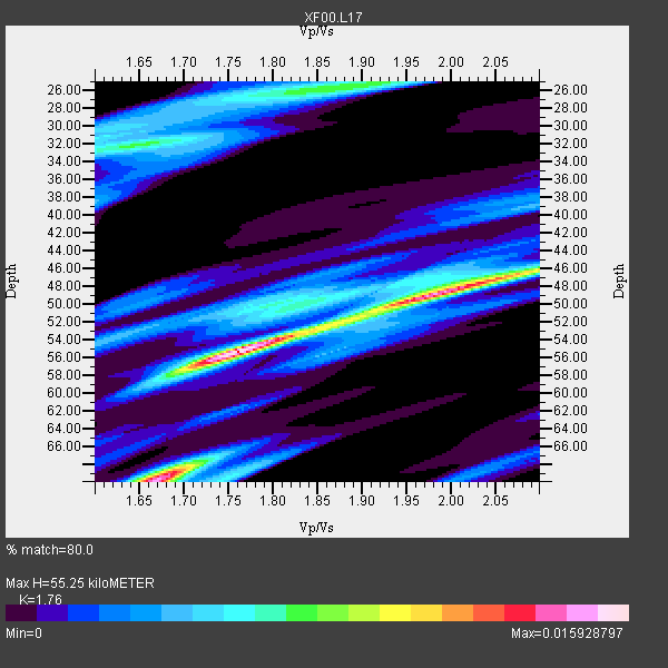
| Thickness Estimate: | 55 km |
| Thickness StdDev: | 15 km |
| Vp/Vs Estimate: | 1.76 |
| Vp/Vs StdDev: | 0.14 |
| Vs Estimate: | 3.583 km/s |
| Poisson's Ratio: | 0.26 |
| Peak Value: | 0.02 |
| Assumed Vp: | 6.306 km/s |
| Ps Weight: | 0.33333334 |
| PpPs Weight: | 0.33333334 |
| PsPs Weight: | 0.33333328 |
| Residual Complexity: | 0.819 |
| Nearby stations H: | 52 km +- 4.2 km |
| (2.0 deg) Vp/Vs: | 1.85 +- 0.13 |
3 with match > 90% ( 33.333332 %) and 9 with match > 80% ( 100.0 %) out of 9.
Download stack as xyz text file.
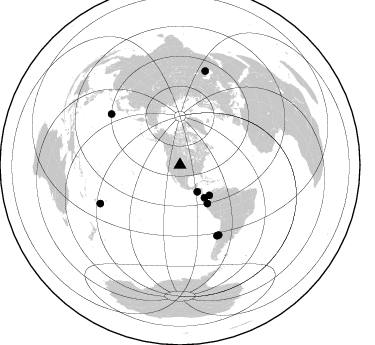
Azimuth Distribution of Events:
Prior Results for this Station
| Study | Thickness | Vp/Vs | Vp | Vs | Poissons Ratio | Extra |
| EARS | 55 km | 1.76 | 6.306 km/s | 3.583 km/s | 0.26 | |
| Crust2.0 | 50 km | 1.76 | 6.306 km/s | 3.584 km/s | 0.26 | P4,orogen/50km, Urals, Tethian Orogen, Rockies 1 km seds. |
| Global Maxima | 55 km | 1.76 | 6.306 km/s | 3.583 km/s | 0.26 | amp=0.015928797 |
| Local Maxima 1 | 70 km | 1.67 | 6.306 km/s | 3.782 km/s | 0.22 | amp=0.014498713 |
| Local Maxima 2 | 49 km | 1.98 | 6.306 km/s | 3.181 km/s | 0.33 | amp=0.013508761 |
| Local Maxima 3 | 26 km | 1.88 | 6.306 km/s | 3.354 km/s | 0.30 | amp=0.007917686 |
| Local Maxima 4 | 32 km | 1.63 | 6.306 km/s | 3.863 km/s | 0.20 | amp=0.0068964073 |
| Predicted Arrivals for vertical incidence (zero ray parameter) | |
| Ps | 6.66 SECOND |
| PpPs | 24.18 SECOND |
| PsPs/PpSs | 30.84 SECOND |
Events Processed for this Station
Download zip of receiver functions as SAC
Plot maxima for each earthquake.
Events Used in the Stack
(9 events)| Radial Match | Distance | Baz | FERegion | Time | Lat/Lon | Depth | Magnitude |
| 93.27718 | 31.9 deg | 147.09 deg | El Salvador | 2001/01/13 17:33:32 GMT | (13.0, -88.7) | 60 km | 6.4 MB, 7.8 MS, 7.7 MW, 7.5 ME |
| 92.391884 | 79.6 deg | 152.41 deg | Off Coast Of Central Chile | 2001/04/09 09:00:57 GMT | (-32.7, -73.1) | 11 km | 6.1 MB, 6.3 MS, 6.7 MW, 6.3 ME |
| 90.293144 | 42.2 deg | 136.175 deg | Panama-Colombia Border Region | 2000/11/08 06:59:58 GMT | (7.0, -77.8) | 17 km | 6.0 MB, 6.4 MS, 6.5 MW, 6.2 ML |
| 86.21496 | 40.8 deg | 143.273 deg | South Of Panama | 2000/12/12 05:26:45 GMT | (6.0, -82.7) | 10 km | 5.8 MB, 5.7 MS, 6.3 ME, 6.1 MW |
| 85.23535 | 85.5 deg | 306.529 deg | Southeast Of Honshu, Japan | 2001/04/14 23:27:26 GMT | (30.1, 141.8) | 10 km | 6.0 MB, 5.8 MS, 6.0 MW, 6.0 ME |
| 82.27665 | 88.3 deg | 244.243 deg | Fiji Islands Region | 2001/04/28 04:49:53 GMT | (-18.1, -176.9) | 352 km | 6.2 MB, 6.8 MW, 6.8 MW |
| 81.5021 | 97.6 deg | 15.019 deg | Turkmenistan | 2000/12/06 17:11:06 GMT | (39.6, 54.8) | 30 km | 6.7 MB, 7.5 MS, 7.0 MW, 6.9 ME |
| 81.03383 | 79.8 deg | 151.003 deg | Near Coast Of Central Chile | 2001/03/15 13:02:42 GMT | (-32.3, -71.5) | 37 km | 6.1 MB, 5.6 MS, 6.0 MW, 5.4 MD |
| 80.73434 | 47.2 deg | 144.535 deg | Near Coast Of Ecuador | 2000/09/28 23:23:43 GMT | (-0.2, -80.6) | 23 km | 5.8 MB, 6.0 MS, 6.6 MW, 6.4 MW |
Losers
(0 events)| Radial Match | Distance | Baz | FERegion | Time | Lat/Lon | Depth | Magnitude | Reason |
