You are here: Home > Network List > XM99 - Rio Grande Seismic Transect Stations List
> Station UT52 Utah52 > Earthquake Result Viewer
UT52 Utah52 - Earthquake Result Viewer
| Earthquake location: |
Tonga Islands |
| Earthquake latitude/longitude: |
-17.2/-173.9 |
| Earthquake time(UTC): |
2000/09/26 (270) 06:17:52 GMT |
| Earthquake Depth: |
56 km |
| Earthquake Magnitude: |
6.1 MB, 6.1 MS, 6.4 MW, 6.1 ME |
| Earthquake Catalog/Contributor: |
WHDF/NEIC |
|
| Network: |
XM Rio Grande Seismic Transect |
| Station: |
UT52 Utah52 |
| Lat/Lon: |
37.23 N/110.13 W |
| Elevation: |
1671 m |
|
| Distance: |
80.8 deg |
| Az: |
46.505 deg |
| Baz: |
240.331 deg |
| Ray Param: |
0.047935214 |
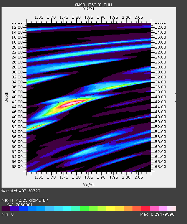
| Estimated Moho Depth: |
42.25 km |
| Estimated Crust Vp/Vs: |
1.79 |
| Assumed Crust Vp: |
6.247 km/s |
| Estimated Crust Vs: |
3.499 km/s |
| Estimated Crust Poisson's Ratio: |
0.27 |
|
| Radial Match: |
97.68729 % |
| Radial Bump: |
308 |
| Transverse Match: |
92.98044 % |
| Transverse Bump: |
400 |
| SOD ConfigId: |
16820 |
| Insert Time: |
2010-02-26 17:28:24.445 +0000 |
| GWidth: |
2.5 |
| Max Bumps: |
400 |
| Tol: |
0.001 |
|

Signal To Noise
| Channel | StoN | STA | LTA |
| XM:UT52:01:BHN:20000926T06:29:28.941006Z | 6.459804 | 2.740449E-7 | 4.24231E-8 |
| XM:UT52:01:BHE:20000926T06:29:28.941006Z | 11.369342 | 5.6807454E-7 | 4.9965475E-8 |
| XM:UT52:01:BHZ:20000926T06:29:28.941006Z | 32.795345 | 1.7891153E-6 | 5.4553944E-8 |
| Arrivals |
| Ps | 5.4 SECOND |
| PpPs | 18 SECOND |
| PsPs/PpSs | 24 SECOND |


