You are here: Home > Network List > XM99 - Rio Grande Seismic Transect Stations List
> Station UT52 Utah52 > Earthquake Result Viewer
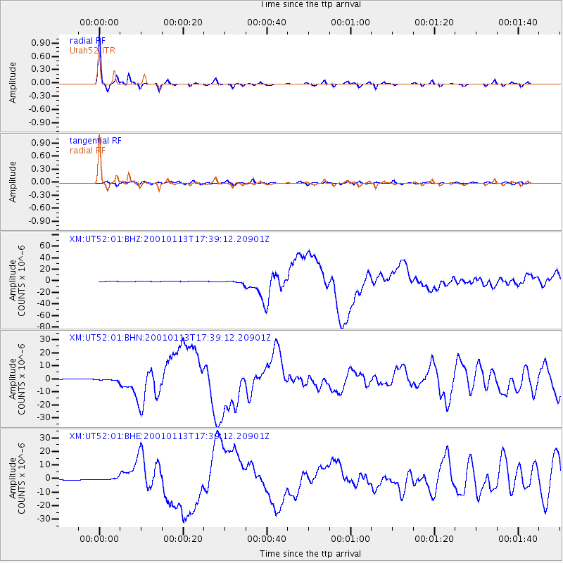
UT52 Utah52 - Earthquake Result Viewer

| Earthquake location: |
El Salvador |
| Earthquake latitude/longitude: |
13.0/-88.7 |
| Earthquake time(UTC): |
2001/01/13 (013) 17:33:32 GMT |
| Earthquake Depth: |
60 km |
| Earthquake Magnitude: |
6.4 MB, 7.8 MS, 7.7 MW, 7.5 ME |
| Earthquake Catalog/Contributor: |
WHDF/NEIC |
|
| Network: |
XM Rio Grande Seismic Transect |
| Station: |
UT52 Utah52 |
| Lat/Lon: |
37.23 N/110.13 W |
| Elevation: |
1671 m |
|
| Distance: |
30.8 deg |
| Az: |
325.212 deg |
| Baz: |
135.842 deg |
| Ray Param: |
0.07915362 |
| Estimated Moho Depth: |
63.25 km |
| Estimated Crust Vp/Vs: |
1.66 |
| Assumed Crust Vp: |
6.247 km/s |
| Estimated Crust Vs: |
3.763 km/s |
| Estimated Crust Poisson's Ratio: |
0.22 |
|
| Radial Match: |
97.67186 % |
| Radial Bump: |
196 |
| Transverse Match: |
79.23362 % |
| Transverse Bump: |
400 |
| SOD ConfigId: |
16820 |
| Insert Time: |
2010-02-26 17:28:29.830 +0000 |
| GWidth: |
2.5 |
| Max Bumps: |
400 |
| Tol: |
0.001 |
|
Signal To Noise
| Channel | StoN | STA | LTA |
| XM:UT52:01:BHN:20010113T17:39:12.20901Z | 3.526266 | 9.2207375E-7 | 2.614873E-7 |
| XM:UT52:01:BHE:20010113T17:39:12.20901Z | 4.594969 | 1.099539E-6 | 2.3929192E-7 |
| XM:UT52:01:BHZ:20010113T17:39:12.20901Z | 6.267148 | 2.6367145E-6 | 4.2072E-7 |
| Arrivals |
| Ps | 7.2 SECOND |
| PpPs | 25 SECOND |
| PsPs/PpSs | 32 SECOND |


