You are here: Home > Network List > XM99 - Rio Grande Seismic Transect Stations List
> Station UT52 Utah52 > Earthquake Result Viewer
UT52 Utah52 - Earthquake Result Viewer
| Earthquake location: |
El Salvador |
| Earthquake latitude/longitude: |
13.7/-88.9 |
| Earthquake time(UTC): |
2001/02/13 (044) 14:22:05 GMT |
| Earthquake Depth: |
10 km |
| Earthquake Magnitude: |
5.5 MB, 6.5 MS, 6.6 MW, 6.1 MD |
| Earthquake Catalog/Contributor: |
WHDF/NEIC |
|
| Network: |
XM Rio Grande Seismic Transect |
| Station: |
UT52 Utah52 |
| Lat/Lon: |
37.23 N/110.13 W |
| Elevation: |
1671 m |
|
| Distance: |
30.1 deg |
| Az: |
324.923 deg |
| Baz: |
135.581 deg |
| Ray Param: |
0.079410985 |
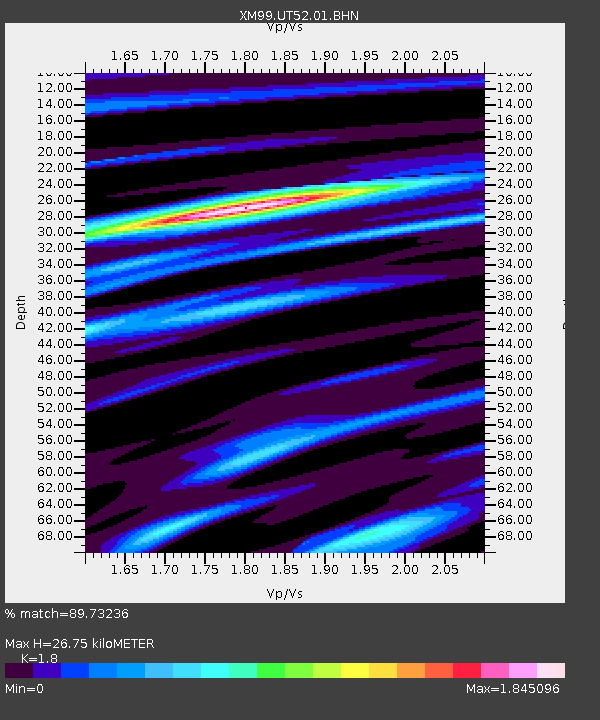
| Estimated Moho Depth: |
26.75 km |
| Estimated Crust Vp/Vs: |
1.80 |
| Assumed Crust Vp: |
6.247 km/s |
| Estimated Crust Vs: |
3.47 km/s |
| Estimated Crust Poisson's Ratio: |
0.28 |
|
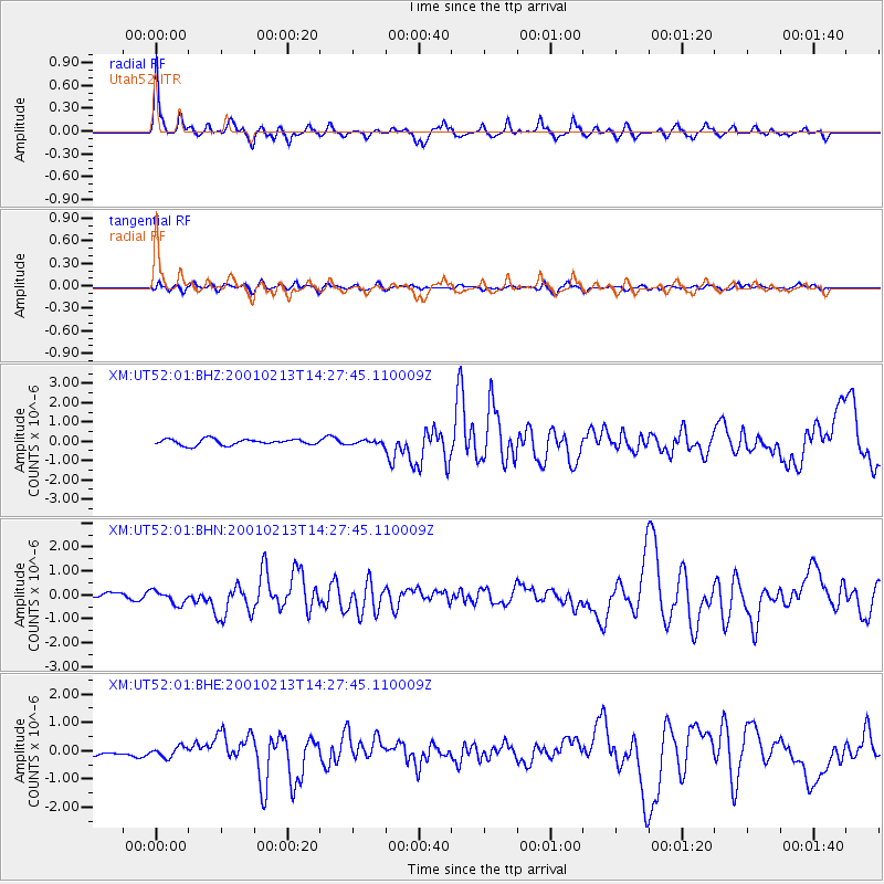
| Radial Match: |
89.73236 % |
| Radial Bump: |
386 |
| Transverse Match: |
67.8637 % |
| Transverse Bump: |
400 |
| SOD ConfigId: |
3744 |
| Insert Time: |
2010-02-26 17:28:33.881 +0000 |
| GWidth: |
2.5 |
| Max Bumps: |
400 |
| Tol: |
0.001 |
|
Signal To Noise
| Channel | StoN | STA | LTA |
| XM:UT52:01:BHN:20010213T14:27:45.110009Z | 2.8693728 | 2.7949636E-7 | 9.740678E-8 |
| XM:UT52:01:BHE:20010213T14:27:45.110009Z | 1.3301874 | 1.83628E-7 | 1.3804672E-7 |
| XM:UT52:01:BHZ:20010213T14:27:45.110009Z | 0.6595688 | 1.0071187E-7 | 1.5269352E-7 |
| Arrivals |
| Ps | 3.7 SECOND |
| PpPs | 11 SECOND |
| PsPs/PpSs | 15 SECOND |


