You are here: Home > Network List > XM99 - Rio Grande Seismic Transect Stations List
> Station UT52 Utah52 > Earthquake Result Viewer
UT52 Utah52 - Earthquake Result Viewer
| Earthquake location: |
Turkey |
| Earthquake latitude/longitude: |
40.7/29.9 |
| Earthquake time(UTC): |
1999/08/17 (229) 00:01:39 GMT |
| Earthquake Depth: |
17 km |
| Earthquake Magnitude: |
6.3 MB, 7.8 MS, 7.7 ME, 7.6 MW |
| Earthquake Catalog/Contributor: |
WHDF/NEIC |
|
| Network: |
XM Rio Grande Seismic Transect |
| Station: |
UT52 Utah52 |
| Lat/Lon: |
37.23 N/110.13 W |
| Elevation: |
1671 m |
|
| Distance: |
94.2 deg |
| Az: |
329.041 deg |
| Baz: |
29.321 deg |
| Ray Param: |
0.041102618 |
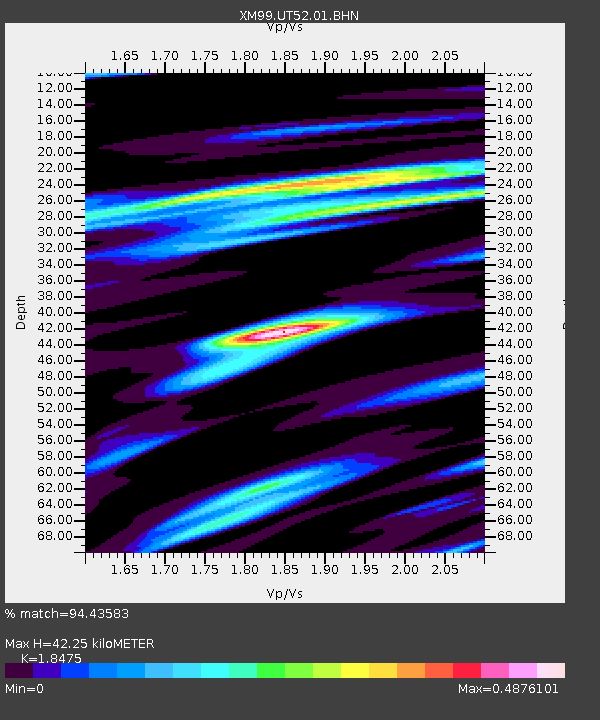
| Estimated Moho Depth: |
42.25 km |
| Estimated Crust Vp/Vs: |
1.85 |
| Assumed Crust Vp: |
6.247 km/s |
| Estimated Crust Vs: |
3.381 km/s |
| Estimated Crust Poisson's Ratio: |
0.29 |
|
| Radial Match: |
94.43583 % |
| Radial Bump: |
374 |
| Transverse Match: |
85.19739 % |
| Transverse Bump: |
400 |
| SOD ConfigId: |
27569 |
| Insert Time: |
2010-02-26 17:28:48.816 +0000 |
| GWidth: |
2.5 |
| Max Bumps: |
400 |
| Tol: |
0.001 |
|

Signal To Noise
| Channel | StoN | STA | LTA |
| XM:UT52:01:BHN:19990817T00:14:25.236995Z | 1.9299225 | 9.714886E-8 | 5.0338222E-8 |
| XM:UT52:01:BHE:19990817T00:14:25.236995Z | 0.96570146 | 5.989004E-8 | 6.2017136E-8 |
| XM:UT52:01:BHZ:19990817T00:14:25.236995Z | 2.1973023 | 1.6811373E-7 | 7.6509146E-8 |
| Arrivals |
| Ps | 5.8 SECOND |
| PpPs | 19 SECOND |
| PsPs/PpSs | 25 SECOND |


