You are here: Home > Network List > XM99 - Rio Grande Seismic Transect Stations List
> Station NM32 NewMexico32 > Earthquake Result Viewer
NM32 NewMexico32 - Earthquake Result Viewer
| Earthquake location: |
Tonga Islands |
| Earthquake latitude/longitude: |
-15.9/-173.7 |
| Earthquake time(UTC): |
2000/09/11 (255) 17:17:53 GMT |
| Earthquake Depth: |
115 km |
| Earthquake Magnitude: |
6.0 MB, 6.3 MW, 6.3 MW |
| Earthquake Catalog/Contributor: |
WHDF/NEIC |
|
| Network: |
XM Rio Grande Seismic Transect |
| Station: |
NM32 NewMexico32 |
| Lat/Lon: |
34.98 N/107.26 W |
| Elevation: |
1685 m |
|
| Distance: |
80.7 deg |
| Az: |
49.69 deg |
| Baz: |
243.337 deg |
| Ray Param: |
0.047808036 |
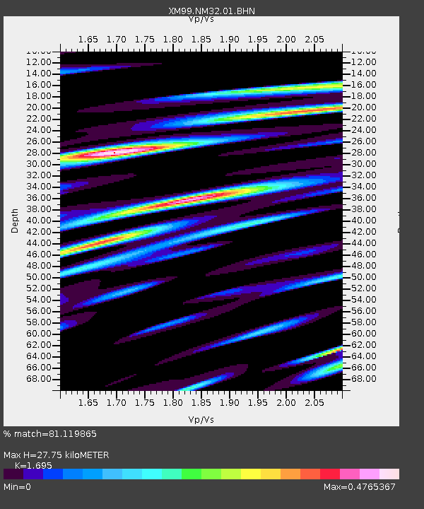
| Estimated Moho Depth: |
27.75 km |
| Estimated Crust Vp/Vs: |
1.70 |
| Assumed Crust Vp: |
6.502 km/s |
| Estimated Crust Vs: |
3.836 km/s |
| Estimated Crust Poisson's Ratio: |
0.23 |
|
| Radial Match: |
81.119865 % |
| Radial Bump: |
399 |
| Transverse Match: |
49.555836 % |
| Transverse Bump: |
400 |
| SOD ConfigId: |
16820 |
| Insert Time: |
2010-02-26 17:29:32.844 +0000 |
| GWidth: |
2.5 |
| Max Bumps: |
400 |
| Tol: |
0.001 |
|
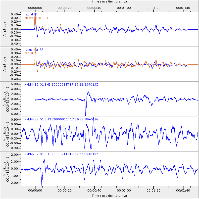
Signal To Noise
| Channel | StoN | STA | LTA |
| XM:NM32:01:BHN:20000911T17:29:22.894019Z | 1.0679637 | 3.7545647E-7 | 3.5156296E-7 |
| XM:NM32:01:BHE:20000911T17:29:22.894019Z | 4.7807975 | 7.319799E-7 | 1.5310833E-7 |
| XM:NM32:01:BHZ:20000911T17:29:22.894019Z | 11.07202 | 2.1011022E-6 | 1.8976684E-7 |
| Arrivals |
| Ps | 3.1 SECOND |
| PpPs | 11 SECOND |
| PsPs/PpSs | 14 SECOND |


