
Station XM NM32 - NewMexico32
Network: XM99 - Rio Grande Seismic Transect
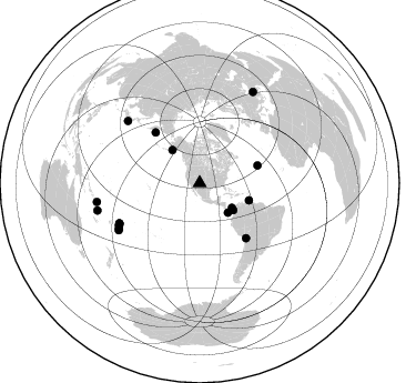
Nearby stations (2 deg radius)
| Station | Name | (Lat, Lon) | Start / End | Elevation |
| NM32 | NewMexico32 | (34.98, -107.26) | 1999-09-15 / 2001-12-31 | 1685 m |
| Crust2 Type: | X2,Rift, Rio Grande, Baikal, 0.5km sediments |
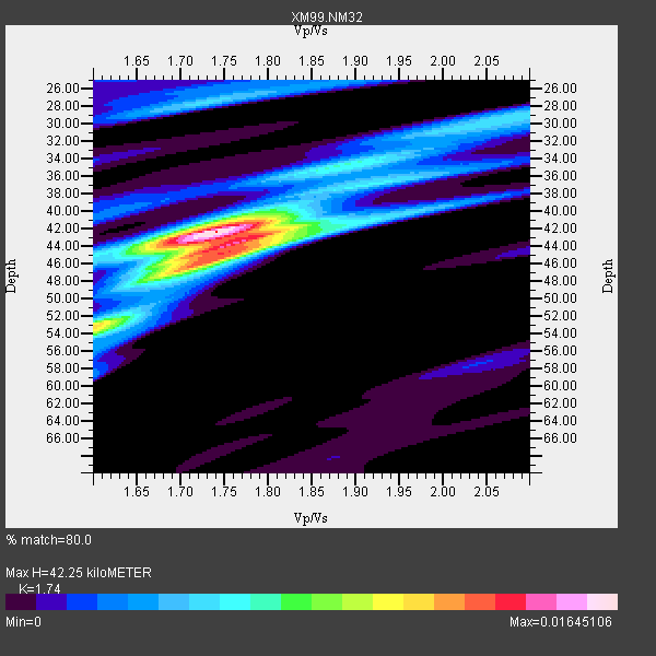
| Thickness Estimate: | 42 km |
| Thickness StdDev: | 3.6 km |
| Vp/Vs Estimate: | 1.74 |
| Vp/Vs StdDev: | 0.06 |
| Vs Estimate: | 3.737 km/s |
| Poisson's Ratio: | 0.25 |
| Peak Value: | 0.02 |
| Assumed Vp: | 6.502 km/s |
| Ps Weight: | 0.33333334 |
| PpPs Weight: | 0.33333334 |
| PsPs Weight: | 0.33333328 |
| Residual Complexity: | 0.646 |
| Nearby stations H: | +- |
| (2.0 deg) Vp/Vs: | +- |
4 with match > 90% ( 21.052631 %) and 18 with match > 80% ( 94.73684 %) out of 19.
Download stack as xyz text file.
Azimuth Distribution of Events:
Prior Results for this Station
| Study | Thickness | Vp/Vs | Vp | Vs | Poissons Ratio | Extra |
| EARS | 42 km | 1.74 | 6.502 km/s | 3.737 km/s | 0.25 | |
| Crust2.0 | 33 km | 1.77 | 6.502 km/s | 3.68 km/s | 0.26 | X2,Rift, Rio Grande, Baikal, 0.5km sediments |
| Wilson | 39 km | 1.77 | 6.09 km/s | 3.441 km/s | 0.27 | |
| Global Maxima | 42 km | 1.74 | 6.502 km/s | 3.737 km/s | 0.25 | amp=0.01645106 |
| Local Maxima 1 | 44 km | 1.76 | 6.502 km/s | 3.694 km/s | 0.26 | amp=0.011390422 |
| Local Maxima 2 | 53 km | 1.60 | 6.502 km/s | 4.063 km/s | 0.18 | amp=0.010277143 |
| Local Maxima 3 | 43 km | 1.79 | 6.502 km/s | 3.632 km/s | 0.27 | amp=0.0072960667 |
| Local Maxima 4 | 27 km | 1.74 | 6.502 km/s | 3.742 km/s | 0.25 | amp=0.0052118166 |
| Predicted Arrivals for vertical incidence (zero ray parameter) | |
| Ps | 4.81 SECOND |
| PpPs | 17.81 SECOND |
| PsPs/PpSs | 22.61 SECOND |
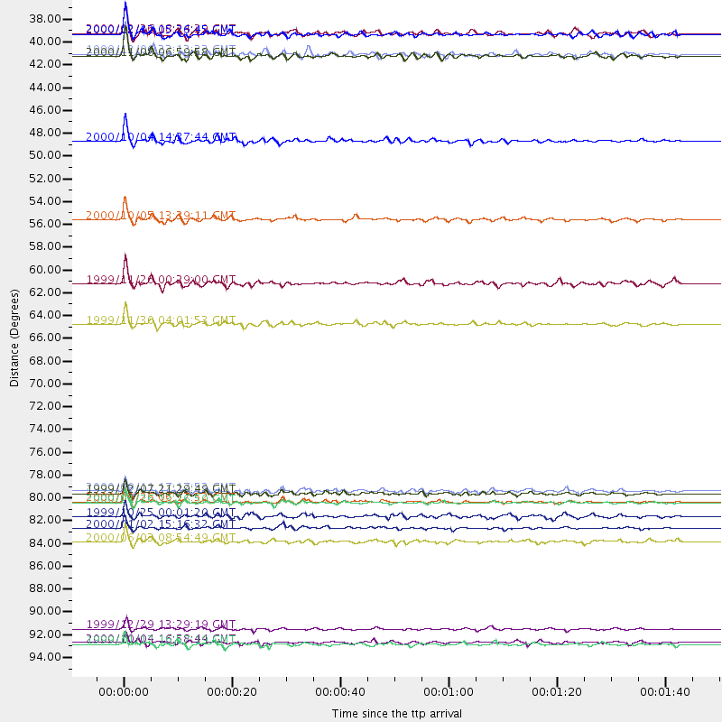
Events Processed for this Station
Download zip of receiver functions as SAC
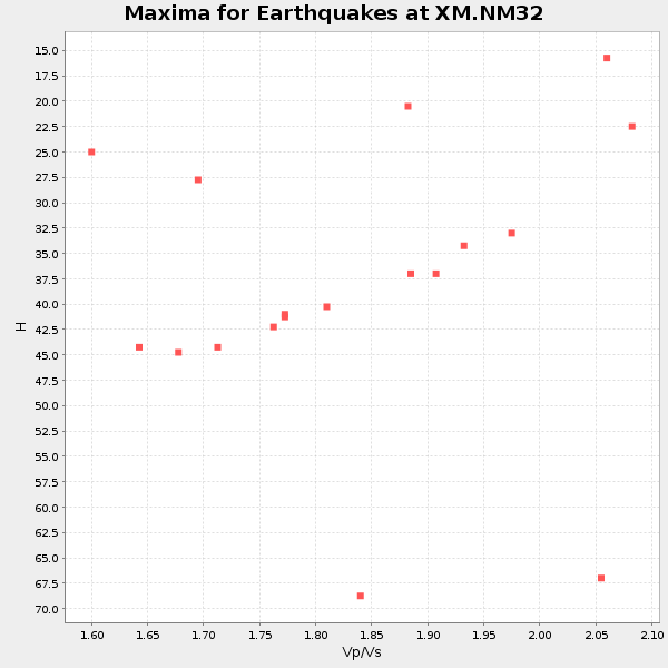
Plot maxima for each earthquake.
Events Used in the Stack
(18 events)| Radial Match | Distance | Baz | FERegion | Time | Lat/Lon | Depth | Magnitude |
| 97.024635 | 47.0 deg | 109.22 deg | Windward Islands | 2000/10/04 14:37:44 GMT | (11.1, -62.6) | 110 km | 5.6 MB, 5.4 MS, 6.1 MW, 5.9 MD |
| 94.99867 | 81.8 deg | 242.488 deg | Tonga Islands | 2000/09/26 06:17:52 GMT | (-17.2, -173.9) | 56 km | 6.1 MB, 6.1 MS, 6.4 MW, 6.1 ME |
| 92.412025 | 38.8 deg | 128.882 deg | Panama-Colombia Border Region | 2000/11/08 06:59:58 GMT | (7.0, -77.8) | 17 km | 6.0 MB, 6.4 MS, 6.5 MW, 6.2 ML |
| 91.40932 | 64.7 deg | 139.737 deg | Northern Chile | 1999/11/30 04:01:53 GMT | (-18.9, -69.2) | 128 km | 6.2 MB, 6.6 MW, 6.5 MW |
| 89.39124 | 54.6 deg | 73.282 deg | Northern Mid-Atlantic Ridge | 2000/10/05 13:39:11 GMT | (31.7, -41.0) | 10 km | 5.4 MB, 6.1 MS, 6.0 MW, 5.9 MW |
| 88.540955 | 60.7 deg | 318.884 deg | Komandorskiye Ostrova Region | 1999/11/26 00:29:00 GMT | (55.1, 165.4) | 33 km | 5.6 MB, 5.8 MS |
| 88.327576 | 38.6 deg | 320.437 deg | Kodiak Island Region, Alaska | 1999/12/06 23:12:33 GMT | (57.4, -154.5) | 66 km | 6.8 MB, 7.0 MW, 7.0 ML |
| 86.56751 | 94.0 deg | 259.644 deg | Santa Cruz Islands | 1999/12/29 13:29:19 GMT | (-10.9, 165.4) | 33 km | 5.6 MB, 6.8 MS, 6.8 MW, 6.3 MW |
| 85.49439 | 36.7 deg | 136.146 deg | South Of Panama | 2000/12/12 05:26:45 GMT | (6.0, -82.7) | 10 km | 5.8 MB, 5.7 MS, 6.3 ME, 6.1 MW |
| 84.4997 | 85.6 deg | 310.815 deg | Near East Coast Of Honshu, Japan | 2000/06/03 08:54:49 GMT | (35.6, 140.5) | 62 km | 5.6 MB, 5.6 MS, 6.1 MW, 6.1 MW |
| 84.442726 | 95.3 deg | 255.038 deg | Vanuatu Islands | 2000/10/04 16:58:44 GMT | (-15.4, 166.9) | 23 km | 6.1 MB, 6.9 MS, 6.8 MW, 6.5 ME |
| 84.18875 | 81.0 deg | 243.496 deg | Tonga Islands | 1999/12/07 21:29:49 GMT | (-15.9, -174.0) | 138 km | 6.2 MB, 6.4 MW, 6.4 MW |
| 83.88225 | 84.3 deg | 239.94 deg | Tonga Islands | 2000/01/02 15:16:32 GMT | (-20.8, -174.2) | 33 km | 5.5 MB, 5.8 MS, 5.8 MW, 5.8 MW |
| 82.58883 | 36.6 deg | 127.234 deg | Panama | 2000/02/26 18:24:39 GMT | (9.4, -78.5) | 65 km | 5.8 MB, 5.4 MS, 6.2 MW, 6.1 MW |
| 82.166595 | 95.5 deg | 30.425 deg | Turkey | 1999/11/12 16:57:19 GMT | (40.8, 31.2) | 10 km | 6.3 MB, 7.5 MS, 7.2 MW, 6.6 ML |
| 81.99382 | 83.2 deg | 240.731 deg | Tonga Islands | 1999/10/25 00:01:20 GMT | (-19.4, -173.9) | 33 km | 5.5 MB, 5.6 MS, 5.8 MW, 5.7 MW |
| 81.119865 | 80.7 deg | 243.337 deg | Tonga Islands | 2000/09/11 17:17:53 GMT | (-15.9, -173.7) | 115 km | 6.0 MB, 6.3 MW, 6.3 MW |
| 81.042694 | 81.9 deg | 242.463 deg | Tonga Islands | 2000/01/26 13:26:50 GMT | (-17.3, -174.0) | 33 km | 5.9 MB, 6.0 MS, 6.4 MW, 6.3 MW |
Losers
(1 events)| Radial Match | Distance | Baz | FERegion | Time | Lat/Lon | Depth | Magnitude | Reason |
| 80.84057 | 85.6 deg | 245.097 deg | Fiji Islands Region | 2000/01/13 20:07:14 GMT | (-17.6, -178.7) | 535 km | 5.4 MB, 6.2 MW, 6.2 MW |
