You are here: Home > Network List > IC - New China Digital Seismograph Network Stations List
> Station HIA Hailar, Neimenggu Autonomous Region, China > Earthquake Result Viewer
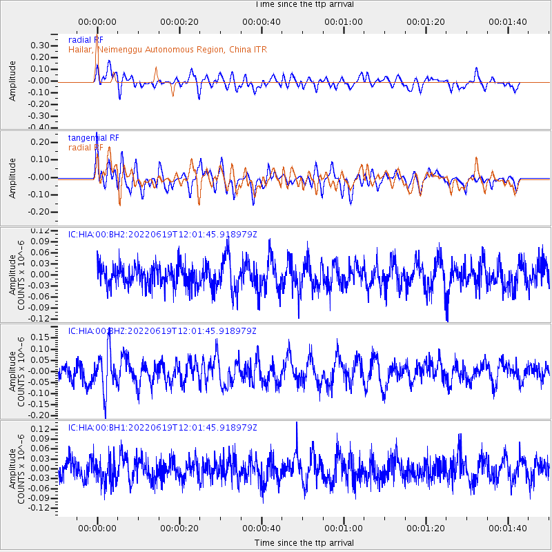
HIA Hailar, Neimenggu Autonomous Region, China - Earthquake Result Viewer
*The percent match for this event was below the threshold and hence no stack was calculated.
| Earthquake location: |
Tonga Islands |
| Earthquake latitude/longitude: |
-20.3/-174.8 |
| Earthquake time(UTC): |
2022/06/19 (170) 11:49:20 GMT |
| Earthquake Depth: |
39 km |
| Earthquake Magnitude: |
5.5 Mww |
| Earthquake Catalog/Contributor: |
NEIC PDE/us |
|
| Network: |
IC New China Digital Seismograph Network |
| Station: |
HIA Hailar, Neimenggu Autonomous Region, China |
| Lat/Lon: |
49.27 N/119.74 E |
| Elevation: |
620 m |
|
| Distance: |
90.3 deg |
| Az: |
323.431 deg |
| Baz: |
121.402 deg |
| Ray Param: |
$rayparam |
*The percent match for this event was below the threshold and hence was not used in the summary stack. |
|
| Radial Match: |
53.75614 % |
| Radial Bump: |
400 |
| Transverse Match: |
46.08177 % |
| Transverse Bump: |
391 |
| SOD ConfigId: |
28208852 |
| Insert Time: |
2022-07-03 12:01:18.414 +0000 |
| GWidth: |
2.5 |
| Max Bumps: |
400 |
| Tol: |
0.001 |
|
Signal To Noise
| Channel | StoN | STA | LTA |
| IC:HIA:00:BHZ:20220619T12:01:45.918979Z | 2.479332 | 9.050379E-8 | 3.6503295E-8 |
| IC:HIA:00:BH1:20220619T12:01:45.918979Z | 1.245396 | 3.631551E-8 | 2.9159809E-8 |
| IC:HIA:00:BH2:20220619T12:01:45.918979Z | 1.796522 | 4.921357E-8 | 2.7393801E-8 |
| Arrivals |
| Ps | |
| PpPs | |
| PsPs/PpSs | |


