You are here: Home > Network List > XM99 - Rio Grande Seismic Transect Stations List
> Station NM29 NewMexico29 > Earthquake Result Viewer
NM29 NewMexico29 - Earthquake Result Viewer
| Earthquake location: |
Kermadec Islands Region |
| Earthquake latitude/longitude: |
-31.3/179.8 |
| Earthquake time(UTC): |
2000/05/08 (129) 21:35:42 GMT |
| Earthquake Depth: |
383 km |
| Earthquake Magnitude: |
5.4 MB, 5.7 MW, 5.6 MW |
| Earthquake Catalog/Contributor: |
WHDF/NEIC |
|
| Network: |
XM Rio Grande Seismic Transect |
| Station: |
NM29 NewMexico29 |
| Lat/Lon: |
34.65 N/106.85 W |
| Elevation: |
1561 m |
|
| Distance: |
95.2 deg |
| Az: |
52.462 deg |
| Baz: |
235.4 deg |
| Ray Param: |
0.04051427 |
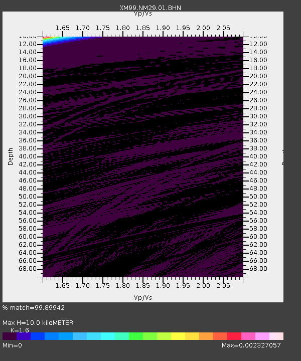
| Estimated Moho Depth: |
10.0 km |
| Estimated Crust Vp/Vs: |
1.60 |
| Assumed Crust Vp: |
6.502 km/s |
| Estimated Crust Vs: |
4.063 km/s |
| Estimated Crust Poisson's Ratio: |
0.18 |
|
| Radial Match: |
99.89942 % |
| Radial Bump: |
6 |
| Transverse Match: |
99.74928 % |
| Transverse Bump: |
37 |
| SOD ConfigId: |
16820 |
| Insert Time: |
2010-02-26 17:31:11.440 +0000 |
| GWidth: |
2.5 |
| Max Bumps: |
400 |
| Tol: |
0.001 |
|
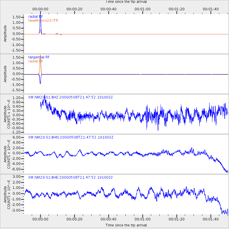
Signal To Noise
| Channel | StoN | STA | LTA |
| XM:NM29:01:BHN:20000508T21:47:52.191003Z | 1.0560912 | 7.594434E-7 | 7.1910773E-7 |
| XM:NM29:01:BHE:20000508T21:47:52.191003Z | 1.2142881 | 4.5365903E-7 | 3.736008E-7 |
| XM:NM29:01:BHZ:20000508T21:47:52.191003Z | 0.9090272 | 3.6944084E-7 | 4.064134E-7 |
| Arrivals |
| Ps | 0.9 SECOND |
| PpPs | 3.9 SECOND |
| PsPs/PpSs | 4.9 SECOND |


