You are here: Home > Network List > XM99 - Rio Grande Seismic Transect Stations List
> Station NM29 NewMexico29 > Earthquake Result Viewer
NM29 NewMexico29 - Earthquake Result Viewer
| Earthquake location: |
Fiji Islands Region |
| Earthquake latitude/longitude: |
-15.5/-177.5 |
| Earthquake time(UTC): |
2000/05/02 (123) 09:58:34 GMT |
| Earthquake Depth: |
401 km |
| Earthquake Magnitude: |
5.3 MB, 5.7 MW |
| Earthquake Catalog/Contributor: |
WHDF/NEIC |
|
| Network: |
XM Rio Grande Seismic Transect |
| Station: |
NM29 NewMexico29 |
| Lat/Lon: |
34.65 N/106.85 W |
| Elevation: |
1561 m |
|
| Distance: |
83.5 deg |
| Az: |
51.53 deg |
| Baz: |
246.259 deg |
| Ray Param: |
0.045030404 |
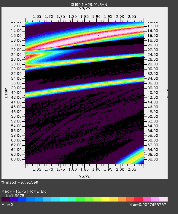
| Estimated Moho Depth: |
15.75 km |
| Estimated Crust Vp/Vs: |
1.91 |
| Assumed Crust Vp: |
6.502 km/s |
| Estimated Crust Vs: |
3.408 km/s |
| Estimated Crust Poisson's Ratio: |
0.31 |
|
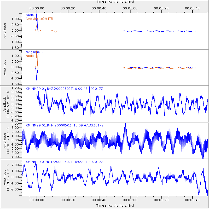
| Radial Match: |
97.91599 % |
| Radial Bump: |
86 |
| Transverse Match: |
94.09319 % |
| Transverse Bump: |
96 |
| SOD ConfigId: |
16820 |
| Insert Time: |
2010-02-26 17:31:12.451 +0000 |
| GWidth: |
2.5 |
| Max Bumps: |
400 |
| Tol: |
0.001 |
|
Signal To Noise
| Channel | StoN | STA | LTA |
| XM:NM29:01:BHN:20000502T10:09:47.392017Z | 0.84453094 | 1.2191723E-6 | 1.4436089E-6 |
| XM:NM29:01:BHE:20000502T10:09:47.392017Z | 1.1679027 | 1.3860832E-6 | 1.186814E-6 |
| XM:NM29:01:BHZ:20000502T10:09:47.392017Z | 1.1530432 | 4.5045627E-7 | 3.9066728E-7 |
| Arrivals |
| Ps | 2.2 SECOND |
| PpPs | 6.9 SECOND |
| PsPs/PpSs | 9.1 SECOND |


