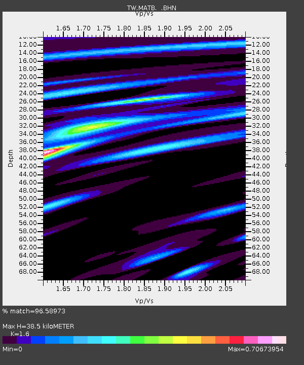
MATB MA-TSU - Earthquake Result Viewer

Earthquake location: New Britain Region, P.N.G.
Earthquake latitude/longitude: -5.5/151.8
Earthquake time(UTC): 2000/11/17 (322) 21:01:56 GMT
Earthquake Depth: 33 km
Earthquake Magnitude: 6.2 MB, 8.0 MS, 7.6 MW, 6.9 ME
Earthquake Catalog/Contributor: WHDF/NEIC
Network: TW Broadband Array in Taiwan for Seismology
Station: MATB MA-TSU
Lat/Lon: 26.15 N/119.95 E
Elevation: 75 m
Distance: 44.1 deg
Az: 317.035 deg
Baz: 130.987 deg
Ray Param: 0.07207527
Estimated Moho Depth: 38.5 km
Estimated Crust Vp/Vs: 1.60
Assumed Crust Vp: 6.276 km/s
Estimated Crust Vs: 3.922 km/s
Estimated Crust Poisson's Ratio: 0.18
Radial Match: 96.58973 %
Radial Bump: 363
Transverse Match: 75.5517 %
Transverse Bump: 400
SOD ConfigId: 3744
Insert Time: 2010-03-09 21:40:35.987 +0000
GWidth: 2.5
Max Bumps: 400
Tol: 0.001

Signal To Noise

ChannelStoNSTALTA
TW:MATB: :BHN:20001117T21:09:30.866007Z0.70602319.335086E-71.3222069E-6
TW:MATB: :BHE:20001117T21:09:30.866007Z0.90042937.2590365E-78.06175E-7
TW:MATB: :BHZ:20001117T21:09:30.866007Z1.15405731.3792319E-61.1951156E-6
Arrivals
Ps3.9 SECOND
PpPs15 SECOND
PsPs/PpSs19 SECOND