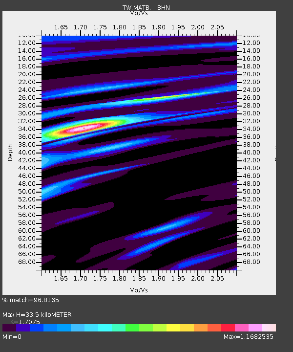
MATB MA-TSU - Earthquake Result Viewer

Earthquake location: Banda Sea
Earthquake latitude/longitude: -4.0/128.0
Earthquake time(UTC): 2001/03/19 (078) 05:52:15 GMT
Earthquake Depth: 33 km
Earthquake Magnitude: 6.0 MB, 6.5 MS, 6.5 MW, 6.5 MW
Earthquake Catalog/Contributor: WHDF/NEIC
Network: TW Broadband Array in Taiwan for Seismology
Station: MATB MA-TSU
Lat/Lon: 26.15 N/119.95 E
Elevation: 75 m
Distance: 31.0 deg
Az: 345.813 deg
Baz: 164.216 deg
Ray Param: 0.07915222
Estimated Moho Depth: 33.5 km
Estimated Crust Vp/Vs: 1.71
Assumed Crust Vp: 6.276 km/s
Estimated Crust Vs: 3.675 km/s
Estimated Crust Poisson's Ratio: 0.24
Radial Match: 96.8165 %
Radial Bump: 264
Transverse Match: 86.520164 %
Transverse Bump: 400
SOD ConfigId: 4714
Insert Time: 2010-03-09 21:41:17.077 +0000
GWidth: 2.5
Max Bumps: 400
Tol: 0.001

Signal To Noise

ChannelStoNSTALTA
TW:MATB: :BHN:20010319T05:58:00.068009Z4.55071075.8615586E-71.2880535E-7
TW:MATB: :BHE:20010319T05:58:00.068009Z1.86837152.459532E-71.3164042E-7
TW:MATB: :BHZ:20010319T05:58:00.068009Z6.5884578.947897E-71.3581173E-7
Arrivals
Ps4.1 SECOND
PpPs13 SECOND
PsPs/PpSs17 SECOND