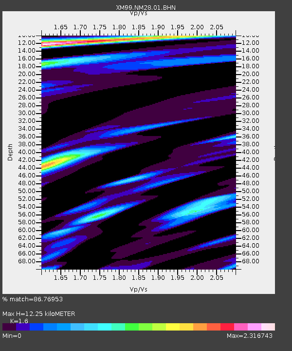
NM28 NewMexico28 - Earthquake Result Viewer
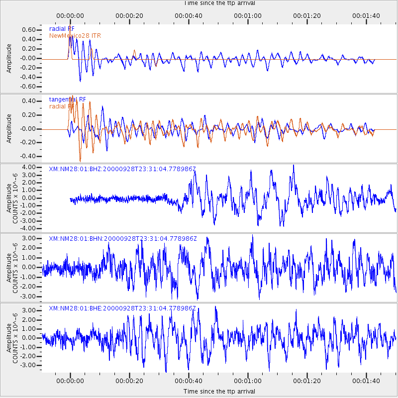
Earthquake location: Near Coast Of Ecuador
Earthquake latitude/longitude: -0.2/-80.6
Earthquake time(UTC): 2000/09/28 (272) 23:23:43 GMT
Earthquake Depth: 23 km
Earthquake Magnitude: 5.8 MB, 6.0 MS, 6.6 MW, 6.4 MW
Earthquake Catalog/Contributor: WHDF/NEIC
Network: XM Rio Grande Seismic Transect
Station: NM28 NewMexico28
Lat/Lon: 34.54 N/106.70 W
Elevation: 1484 m
Distance: 42.3 deg
Az: 327.351 deg
Baz: 139.191 deg
Ray Param: 0.07319538
Estimated Moho Depth: 12.25 km
Estimated Crust Vp/Vs: 1.60
Assumed Crust Vp: 6.502 km/s
Estimated Crust Vs: 4.063 km/s
Estimated Crust Poisson's Ratio: 0.18
Radial Match: 86.76953 %
Radial Bump: 400
Transverse Match: 75.29658 %
Transverse Bump: 400
SOD ConfigId: 27569
Insert Time: 2010-02-26 17:31:17.707 +0000
GWidth: 2.5
Max Bumps: 400
Tol: 0.001

Signal To Noise

ChannelStoNSTALTA
XM:NM28:01:BHN:20000928T23:31:04.778986Z1.11003635.1237964E-74.615882E-7
XM:NM28:01:BHE:20000928T23:31:04.778986Z1.11206575.061833E-74.5517396E-7
XM:NM28:01:BHZ:20000928T23:31:04.778986Z1.48011883.5852102E-72.422245E-7
Arrivals
Ps1.2 SECOND
PpPs4.5 SECOND
PsPs/PpSs5.8 SECOND