
Station XM NM28 - NewMexico28
Network: XM99 - Rio Grande Seismic Transect
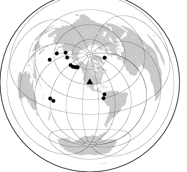
Nearby stations (2 deg radius)
| Station | Name | (Lat, Lon) | Start / End | Elevation |
| NM28 | NewMexico28 | (34.54, -106.70) | 1999-07-06 / 2001-12-31 | 1484 m |
| Crust2 Type: | X2,Rift, Rio Grande, Baikal, 0.5km sediments |
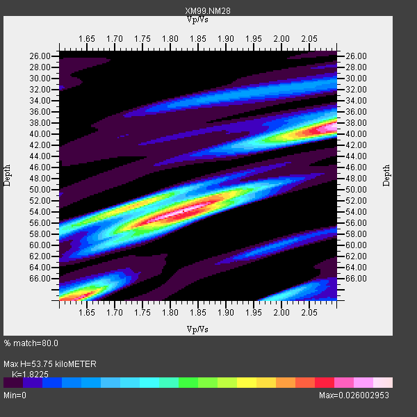
| Thickness Estimate: | 54 km |
| Thickness StdDev: | 11 km |
| Vp/Vs Estimate: | 1.82 |
| Vp/Vs StdDev: | 0.18 |
| Vs Estimate: | 3.567 km/s |
| Poisson's Ratio: | 0.28 |
| Peak Value: | 0.03 |
| Assumed Vp: | 6.502 km/s |
| Ps Weight: | 0.33333334 |
| PpPs Weight: | 0.33333334 |
| PsPs Weight: | 0.33333328 |
| Residual Complexity: | 0.757 |
| Nearby stations H: | +- |
| (2.0 deg) Vp/Vs: | +- |
2 with match > 90% ( 10.526316 %) and 14 with match > 80% ( 73.68421 %) out of 19.
Download stack as xyz text file.
Azimuth Distribution of Events:
Prior Results for this Station
| Study | Thickness | Vp/Vs | Vp | Vs | Poissons Ratio | Extra |
| EARS | 54 km | 1.82 | 6.502 km/s | 3.567 km/s | 0.28 | |
| Crust2.0 | 33 km | 1.77 | 6.502 km/s | 3.68 km/s | 0.26 | X2,Rift, Rio Grande, Baikal, 0.5km sediments |
| Wilson | 37 km | 1.78 | 6.16 km/s | 3.461 km/s | 0.27 | |
| Global Maxima | 54 km | 1.82 | 6.502 km/s | 3.567 km/s | 0.28 | amp=0.026002953 |
| Local Maxima 1 | 38 km | 2.10 | 6.502 km/s | 3.1 km/s | 0.35 | amp=0.025300607 |
| Local Maxima 2 | 69 km | 1.64 | 6.502 km/s | 3.958 km/s | 0.21 | amp=0.01966319 |
| Local Maxima 3 | 53 km | 1.73 | 6.502 km/s | 3.769 km/s | 0.25 | amp=0.018134646 |
| Local Maxima 4 | 51 km | 1.89 | 6.502 km/s | 3.445 km/s | 0.30 | amp=0.011983895 |
| Predicted Arrivals for vertical incidence (zero ray parameter) | |
| Ps | 6.80 SECOND |
| PpPs | 23.33 SECOND |
| PsPs/PpSs | 30.13 SECOND |
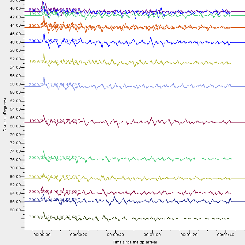
Events Processed for this Station
Download zip of receiver functions as SAC
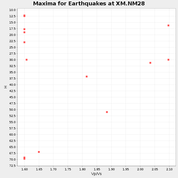
Plot maxima for each earthquake.
Events Used in the Stack
(14 events)| Radial Match | Distance | Baz | FERegion | Time | Lat/Lon | Depth | Magnitude |
| 92.46763 | 76.9 deg | 320.669 deg | Sakhalin, Russia | 2000/08/04 21:13:02 GMT | (48.8, 142.2) | 10 km | 6.3 MB, 7.1 MS, 6.8 MW, 6.7 MW |
| 91.99068 | 92.4 deg | 299.171 deg | Volcano Islands, Japan Region | 2000/03/28 11:00:22 GMT | (22.3, 143.7) | 126 km | 6.8 MB, 7.6 MS, 7.6 MW, 7.6 MW |
| 88.89076 | 67.2 deg | 317.256 deg | Near East Coast Of Kamchatka | 1999/09/18 21:28:33 GMT | (51.2, 157.6) | 60 km | 5.9 MB, 5.6 MS, 6.2 MW, 6.0 MW |
| 87.79301 | 85.8 deg | 247.792 deg | Fiji Islands | 2000/09/14 14:59:57 GMT | (-15.7, 179.8) | 33 km | 5.7 MB, 6.2 MS, 6.3 MW, 6.2 MW |
| 86.76953 | 42.3 deg | 139.191 deg | Near Coast Of Ecuador | 2000/09/28 23:23:43 GMT | (-0.2, -80.6) | 23 km | 5.8 MB, 6.0 MS, 6.6 MW, 6.4 MW |
| 85.170296 | 82.0 deg | 242.894 deg | Tonga Islands | 2000/09/26 06:17:52 GMT | (-17.2, -173.9) | 56 km | 6.1 MB, 6.1 MS, 6.4 MW, 6.1 ME |
| 84.37457 | 87.9 deg | 310.845 deg | Near S. Coast Of Honshu, Japan | 2000/07/01 07:01:55 GMT | (34.2, 139.1) | 10 km | 6.0 MB, 6.1 MS, 6.2 MW, 6.2 MW |
| 84.28338 | 57.8 deg | 31.313 deg | Iceland | 2000/06/21 00:51:46 GMT | (64.0, -20.8) | 10 km | 6.1 MB, 6.6 MS, 6.5 MW, 6.4 MW |
| 83.02939 | 38.5 deg | 320.432 deg | Kodiak Island Region, Alaska | 2001/01/10 16:02:44 GMT | (57.1, -153.2) | 33 km | 6.2 MB, 6.8 MS, 7.1 MW, 6.8 ML |
| 82.40638 | 38.2 deg | 129.14 deg | Panama-Colombia Border Region | 2000/11/08 06:59:58 GMT | (7.0, -77.8) | 17 km | 6.0 MB, 6.4 MS, 6.5 MW, 6.2 ML |
| 81.924995 | 39.2 deg | 320.575 deg | Kodiak Island Region, Alaska | 1999/12/07 00:19:49 GMT | (57.4, -154.5) | 41 km | 6.5 MB, 6.1 MS, 6.4 MW, 6.3 ML |
| 81.60474 | 46.4 deg | 312.381 deg | Fox Islands, Aleutian Islands | 2000/12/05 22:11:34 GMT | (52.6, -167.8) | 33 km | 5.6 MB, 5.6 MS, 5.9 MW, 5.4 ML |
| 81.51577 | 42.4 deg | 315.503 deg | Alaska Peninsula | 1999/10/13 01:33:40 GMT | (54.7, -161.2) | 30 km | 6.0 MB, 6.2 MS, 6.5 MW, 6.0 ML |
| 81.02645 | 51.6 deg | 311.688 deg | Andreanof Islands, Aleutian Is. | 1999/08/01 12:47:50 GMT | (51.5, -176.3) | 33 km | 5.5 MB, 5.5 MS, 5.8 MW, 5.8 MW |
Losers
(5 events)| Radial Match | Distance | Baz | FERegion | Time | Lat/Lon | Depth | Magnitude | Reason |
| 95.8843 | 96.9 deg | 248.146 deg | Southeast Of Loyalty Islands | 2001/02/28 13:05:31 GMT | (-22.0, 170.1) | 10 km | 5.8 MB, 6.1 MS, 6.2 MW | |
| 91.66344 | 46.4 deg | 109.294 deg | Windward Islands | 2000/10/04 14:37:44 GMT | (11.1, -62.6) | 110 km | 5.6 MB, 5.4 MS, 6.1 MW, 5.9 MD | |
| 84.01524 | 80.3 deg | 155.84 deg | Off Coast Of Southern Chile | 1999/08/22 09:35:39 GMT | (-40.5, -74.8) | 33 km | 6.2 MB, 5.8 MS, 6.4 MW, 6.2 MW | |
| 81.38112 | 81.0 deg | 243.754 deg | Tonga Islands | 2000/09/11 17:17:53 GMT | (-15.9, -173.7) | 115 km | 6.0 MB, 6.3 MW, 6.3 MW | |
| 80.99637 | 44.9 deg | 136.39 deg | Ecuador | 1999/08/28 12:40:06 GMT | (-1.3, -77.5) | 196 km | 5.9 MB, 6.3 MW, 6.2 MW |
