NM28 NewMexico28 - Earthquake Result Viewer
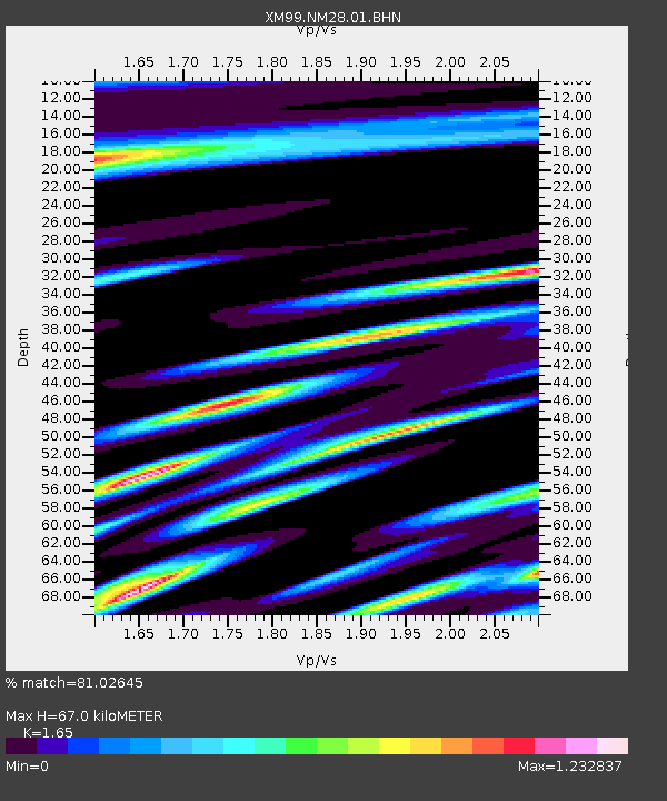
Earthquake location: Andreanof Islands, Aleutian Is.
Earthquake latitude/longitude: 51.5/-176.3
Earthquake time(UTC): 1999/08/01 (213) 12:47:50 GMT
Earthquake Depth: 33 km
Earthquake Magnitude: 5.5 MB, 5.5 MS, 5.8 MW, 5.8 MW
Earthquake Catalog/Contributor: WHDF/NEIC
Network: XM Rio Grande Seismic Transect
Station: NM28 NewMexico28
Lat/Lon: 34.54 N/106.70 W
Elevation: 1484 m
Distance: 51.6 deg
Az: 80.628 deg
Baz: 311.688 deg
Ray Param: 0.06722306
Estimated Moho Depth: 67.0 km
Estimated Crust Vp/Vs: 1.65
Assumed Crust Vp: 6.502 km/s
Estimated Crust Vs: 3.94 km/s
Estimated Crust Poisson's Ratio: 0.21
Radial Match: 81.02645 %
Radial Bump: 400
Transverse Match: 74.93808 %
Transverse Bump: 400
SOD ConfigId: 27569
Insert Time: 2010-02-26 17:31:31.094 +0000
GWidth: 2.5
Max Bumps: 400
Tol: 0.001

Signal To Noise

ChannelStoNSTALTA
XM:NM28:01:BHN:19990801T12:56:22.941006Z0.768872268.0135493E-71.0422472E-6
XM:NM28:01:BHE:19990801T12:56:22.941006Z0.86444547.248533E-78.3851836E-7
XM:NM28:01:BHZ:19990801T12:56:22.941006Z1.1181516.4610197E-75.7783075E-7
Arrivals
Ps7.1 SECOND
PpPs26 SECOND
PsPs/PpSs33 SECOND